1920s Maps of Humboldt County, California
Explore 11 historic maps of Humboldt County from the 1920s. These maps offer a rare glimpse into what life looked like during the 1920s — showing old roads, neighborhoods, homes, and landmarks that have changed or disappeared over time.
Whether you're researching your family's past, planning a metal detecting trip, or studying how Humboldt County's landscape evolved across the 1920s, these high-resolution maps are a powerful tool for exploring the history of this region.
- Focus on a specific era: All maps on this page are from the 1920s, giving you a focused view of this time period.
- See what’s changed: Compare century-old streets, trails, and buildings to today's modern landscape using overlays and satellite layers.
- Research with precision: Use these maps for genealogy, historical research, land use analysis, or educational projects.
- View, download, or print: Maps are fully viewable online in high resolution, and can be downloaded or printed for your own records.
Start exploring Humboldt County's history through authentic maps from the 1920s. This is your window into the past.
Humboldt County, CA maps
(11)- 1920 Map of Pt. Delagda
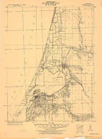
 1920 Pt. Delagda1920 Print · USGSThe Humboldt County coast in the years following the Great War remained a remote landscape of family-run operations and steep shorelines. Researchers can trace early ranching sites and coastal landmarks like Shelter Cove, Etters Ranch, and Honey Dew.
 - 1920 Map of Harris
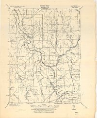
 1920 Harris1920 Print · USGSHumboldt County ranching and rail life are recorded here during the early twentieth century as the railroad carved its path through the Eel River canyon. Researchers can trace historic family holdings like Carey Ranch or locate early industrial sites such as the Steelhead US Fish Hatchery and Fort Seward.
 - 1921 Map of Dyerville
 1921 Dyerville1921 Print · USGSNorthern California river country comes alive in the early twentieth century as the rail and timber industries expand. Trace family history and defunct rail stops through Dyerville, Pepperwood, and family landmarks like Eaton Ranch or the PAC. LBR. CO. SIDING.
 - 1921 Map of Briceland
 1921 Briceland1921 Print · USGSHumboldt County ranching and river life are captured here during the first World War, showing the early infrastructure of the redwood region. Researchers can locate numerous family holdings like the Ben Stoddard Ranch and settlements at Briceland and Garberville.2 unique versions available
 - 1921 Map of Cape Mendocino
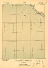
 1921 Cape Mendocino1921 Print · USGSCoastal Humboldt County was a region of scattered homesteads and river valleys in the early 1920s. Genealogists and researchers can trace family-named locations such as Hansens and Prestons, or locate the Race Track near Petrolia.
 - 1922 Map of Eureka
 1922 Eureka1922 Print · USGSHumboldt Bay and the redwood coast are captured in the early twenties as the region’s timber and rail economy reached its height. Genealogists and historians can trace family-named settlements like John Brown and Wheeler, or locate industrial sites such as the Shingle Mill and the Arcata Wharf.
 - 1922 Map of Korbel
 1922 Korbel1922 Print · USGSHumboldt County’s timber and rail economy is on full display in the early 1920s as rail lines converge along the Mad River. Genealogists and historians can trace family-named outposts like Berry's, Bairs, and Murphy or follow the early tracks of the Arcata and Mad River Railroad.
 - 1922 Map of China Flat
 1922 China Flat1922 Print · USGSNorthwestern California at the dawn of the 1920s reveals a landscape of isolated river settlements and early forest service outposts. Genealogists and historians can trace the residents of Quinby and Uptons or locate the China Flat Post Office and Handy Horse Ranger Station.
 - 1922 Map of Kneeland, 1938 Print
 1922 Kneeland1938 Print · USGSHumboldt County’s mountain ridges and river valleys are captured here in the early twenties, showing a landscape of remote outposts and forest boundaries. Genealogists and researchers can locate old sites like Fort Baker, Redwood House, and the settlement of Kneeland.
 - 1925 Map of Hoopa
 1925 Hoopa1925 Print · USGSNorthwestern California in the mid-twenties centers on the vital corridors of the Klamath River and the Hoopa Valley Indian Reservation. Genealogists and historians can trace riverside settlements and landmarks like Martins Ferry, Weitchpec, and Orleans.
 - 1926 Map of Gorda
 1926 Gorda1926 Print · USGSThe Humboldt County coast in the mid-1920s is captured in this tactical chart of the shoreline and its precipitous inland peaks. Researchers can locate coastal landmarks like Gorda Rock, Spanish Flat, and the high summit of Gorda 2365.2 unique versions available
End of results
Showing maps 1-11 of 11
Top cities of Humboldt County
- Eureka historical maps
- Arcata historical maps
- McKinleyville historical maps
- Fortuna historical maps
- Fortuna historical maps
- Rio Dell historical maps
See more
Frequently asked questions
- What are the different types of historical maps available for Humboldt County?
- What is the oldest map of Humboldt County?
- Where can I purchase historical maps of Humboldt County for my home or office?
- Where can I download high-res historical maps of Humboldt County?
- Are there historical topographic maps available for Humboldt County?
- Is there historical aerial imagery available for Humboldt County?
- Where are historical maps of Humboldt County sourced from?