1900s (20th Century) Maps of Glenhaven, California
Explore 10 historic maps of Glenhaven from the 1900s (20th Century). These maps offer a rare glimpse into what life looked like during the 1900s — showing old roads, neighborhoods, homes, and landmarks that have changed or disappeared over time.
Whether you're researching your family's past, planning a metal detecting trip, or studying how Glenhaven's landscape evolved across the 1900s, these high-resolution maps are a powerful tool for exploring the history of this region.
- Focus on a specific era: All maps on this page are from the 1900s, giving you a focused view of this time period.
- See what’s changed: Compare century-old streets, trails, and buildings to today's modern landscape using overlays and satellite layers.
- Research with precision: Use these maps for genealogy, historical research, land use analysis, or educational projects.
- View, download, or print: Maps are fully viewable online in high resolution, and can be downloaded or printed for your own records.
Start exploring Glenhaven's history through authentic maps from the 1900s. This is your window into the past.
Glenhaven, CA maps
(10)- 1924 Map of Bartlett Springs
 1924 Bartlett Springs1924 Print · USGSNorthern Lake County mineral springs and canyons are captured here in the years following the Great War. Genealogists and historians can trace the early resort era at Bartlett Springs, Allen Springs, and the waters of Clear Lake.
 - 1942 Map of Bartlett Springs
 1942 Bartlett Springs1942 Print · USGSLake County and the rugged North Coast Ranges are captured here in the early 1940s, balancing resort springs with hardscrabble ranching. Genealogists can locate family landmarks like Garner Ranch, the East Lake Sch, and the isolated Bartlett Springs resort.
 - 1944 Map of Bartlett Springs
 1944 Bartlett Springs1944 Print · USGSLake County at the height of the war years reveals a landscape of isolated springs and family-run ranches nestled along the high ridges. Researchers can trace historic homesteads like the Garner Ranch, the site of Bartlett Springs, and the East Lake Sch near the Clear Lake shoreline.2 unique versions available
 - 1957 Map of Ukiah, 1966 Print
 1957 Ukiah1966 Print · USGSNorthern California's diverse terrain comes into focus in the mid-1950s, from the rugged timberlands of the Jackson State Forest to the productive Sacramento Valley. Genealogists and historians can trace the rail lines of the Northwestern Pacific or locate early valley settlements like Arbuckle and Paskenta.3 unique versions available
 - 1958 Map of Clearlake Oaks, 1961 Print
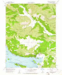 1958 Clearlake Oaks1961 Print · USGSClear Lake’s northeast shore comes into focus during the late 1950s, showing the early development of Clearlake Oaks and Glenhaven. Researchers can trace the legacy of local industry and education at the Sulphur Bank Mine, SULPHUR BANK RANCHERIA, and the East Lake School.7 unique versions available
 - 1960 Map of Ukiah
 1960 Ukiah1960 Print · USGSNorthern California during the late fifties reveals a landscape of deep timber forests and valley agriculture before modern expansion. Trace the historic rail lines of the California Western RR and the Northwestern Pacific RR through settlements like Fort Bragg and Ukiah.2 unique versions available
 - 1960 Map of Clearlake Oaks, 1962 Print
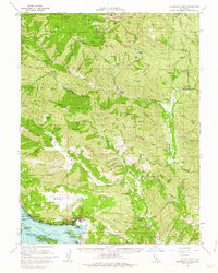 1960 Clearlake Oaks1962 Print · USGSThe eastern shores of Clear Lake and the deep canyons of the Mendocino National Forest are captured here in the early sixties. Researchers can trace the layout of Sulphur Bank Rancheria or locate historic mineral sites like Bartlett Springs and Hough Springs.2 unique versions available
 - 1977 Map of Clearlake Oaks, 1980 Print
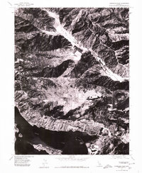 1977 Clearlake Oaks1980 Print · USGSClearlake Oaks and the northern shores of Clear Lake are captured in the late 1970s through this aerial orthophoto. Trace the development of lakeside neighborhoods in Clearlake Oaks and Glenhaven or the open stretches of Long Valley.
 - 1994 Map of Lakeport
 1994 Lakeport1994 Print · USGSCoastal mountains meet the fertile Sacramento Valley in the 1990s, where the waters of Clear Lake define the western landscape. Researchers can trace the industrial footprint of the Sulphur Bank Mine, follow the Southern Pacific RR tracks, or locate old settlements like Fouts Springs and Lodoga.
 - 1996 Map of Clearlake Oaks, 2001 Print
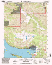 1996 Clearlake Oaks2001 Print · USGSThe Clear Lake shoreline in the late nineties showcases a unique mix of mid-century development and rugged ranching history. Researchers can trace family-named landmarks like Schindler Ranch or locate the industrial footprint of the Sulphur Bank Mine.
End of results
Showing maps 1-10 of 10
Top cities near Glenhaven
- Clearlake historical maps
- Lakeport historical maps
- Clearlake Riviera historical maps
- Kelseyville historical maps
- Lucerne historical maps
- Nice historical maps
See more
Frequently asked questions
- What are the different types of historical maps available for Glenhaven?
- What is the oldest map of Glenhaven?
- Where can I purchase historical maps of Glenhaven for my home or office?
- Where can I download high-res historical maps of Glenhaven?
- Are there historical topographic maps available for Glenhaven?
- Is there historical aerial imagery available for Glenhaven?
- Where are historical maps of Glenhaven sourced from?