1900s (20th Century) Maps of Upper Lake, California
Explore 11 historic maps of Upper Lake from the 1900s (20th Century). These maps offer a rare glimpse into what life looked like during the 1900s — showing old roads, neighborhoods, homes, and landmarks that have changed or disappeared over time.
Whether you're researching your family's past, planning a metal detecting trip, or studying how Upper Lake's landscape evolved across the 1900s, these high-resolution maps are a powerful tool for exploring the history of this region.
- Focus on a specific era: All maps on this page are from the 1900s, giving you a focused view of this time period.
- See what’s changed: Compare century-old streets, trails, and buildings to today's modern landscape using overlays and satellite layers.
- Research with precision: Use these maps for genealogy, historical research, land use analysis, or educational projects.
- View, download, or print: Maps are fully viewable online in high resolution, and can be downloaded or printed for your own records.
Start exploring Upper Lake's history through authentic maps from the 1900s. This is your window into the past.
Upper Lake, CA maps
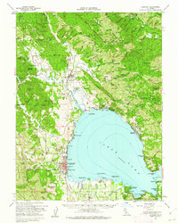
(11)- 1938 Map of Lakeport
 1938 Lakeport1938 Print · USGSLake County in the late thirties is captured here at a peak of lakeside development and rural industry. Genealogists and historians can trace family-named sites like Jones Ranch and Mission Rancheria, or locate old schoolhouses like Westlake Sch and Glen Eden Sch.3 unique versions available
 - 1951 Map of Lakeport, 1953 Print
 1951 Lakeport1953 Print · USGSNorthern California lake life and tribal history meet in the early fifties around the shores of Clear Lake. Trace the locations of the Upper Lake Rancheria, the Bloody Island Massacre Historic Marker, and the early layout of Lakeport.2 unique versions available
 - 1957 Map of Ukiah, 1966 Print
 1957 Ukiah1966 Print · USGSNorthern California's diverse terrain comes into focus in the mid-1950s, from the rugged timberlands of the Jackson State Forest to the productive Sacramento Valley. Genealogists and historians can trace the rail lines of the Northwestern Pacific or locate early valley settlements like Arbuckle and Paskenta.3 unique versions available
 - 1958 Map of Upper Lake, 1961 Print
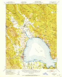
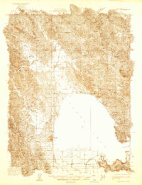
 1958 Upper Lake1961 Print · USGSUpper Lake and the Bachelor Valley are shown here in the late fifties as agriculture and tribal lands met the forest edge. Local historians can find the Bloody Island Massacre Historical Marker, the Witter Springs P.O., and several rancheria tracts.3 unique versions available
 - 1958 Map of Lakeport, 1962 Print
 1958 Lakeport1962 Print · USGSClear Lake and its surrounding rancherias are shown in detail during the late fifties as the region's agricultural and resort communities thrived. Researchers can trace local landmarks like Saratoga Springs, the Bloody Island Massacre Historical Marker, and Robinson Rancheria.3 unique versions available
 - 1960 Map of Ukiah
 1960 Ukiah1960 Print · USGSNorthern California during the late fifties reveals a landscape of deep timber forests and valley agriculture before modern expansion. Trace the historic rail lines of the California Western RR and the Northwestern Pacific RR through settlements like Fort Bragg and Ukiah.2 unique versions available
 - 1977 Map of Upper Lake, 1980 Print
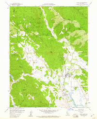
 1977 Upper Lake1980 Print · USGSUpper Lake and the surrounding valley are captured in high-altitude detail during the late seventies, showing the region's agricultural footprint. Trace the path of Middle Creek through the orchards of Bachelor Valley toward the base of White Rock Mtn.
 - 1983 Map of Lakeport
 1983 Lakeport1983 Print · USGSClear Lake and the surrounding hills of Lake County are captured in the early 1930s during a period of agricultural growth and lakeshore development. Genealogists can locate family sites near Lakeport or trace rural landmarks like Witter Springs and Kelsey Creek Sch.
 - 1991 Map of Upper Lake, 1995 Print
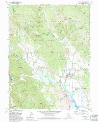 1991 Upper Lake1995 Print · USGSUpper Lake and the surrounding rancherias are shown here during the late twentieth century, before major changes to the valley drainage. You can trace local history through the Bloody Island Massacre Historical Marker, the Witter Springs P O, and several area schools like Union High Sch.
 - 1994 Map of Lakeport
 1994 Lakeport1994 Print · USGSCoastal mountains meet the fertile Sacramento Valley in the 1990s, where the waters of Clear Lake define the western landscape. Researchers can trace the industrial footprint of the Sulphur Bank Mine, follow the Southern Pacific RR tracks, or locate old settlements like Fouts Springs and Lodoga.
 - 1996 Map of Upper Lake, 2001 Print
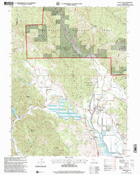 1996 Upper Lake2001 Print · USGSUpper Lake and the Mendocino foothills appear in the mid-nineties as a landscape of tribal rancherias, historic springs, and valley agriculture. Genealogists can locate family landmarks like Witter Springs, Hunter Ranch, and the Union High Sch.
End of results
Showing maps 1-11 of 11
Top cities near Upper Lake
- Clearlake historical maps
- Lakeport historical maps
- Clearlake Riviera historical maps
- Kelseyville historical maps
- Lucerne historical maps
- Nice historical maps
See more
Frequently asked questions
- What are the different types of historical maps available for Upper Lake?
- What is the oldest map of Upper Lake?
- Where can I purchase historical maps of Upper Lake for my home or office?
- Where can I download high-res historical maps of Upper Lake?
- Are there historical topographic maps available for Upper Lake?
- Is there historical aerial imagery available for Upper Lake?
- Where are historical maps of Upper Lake sourced from?