1950s Maps of Napa County, California
Explore 33 historic maps of Napa County from the 1950s. These maps offer a rare glimpse into what life looked like during the 1950s — showing old roads, neighborhoods, homes, and landmarks that have changed or disappeared over time.
Whether you're researching your family's past, planning a metal detecting trip, or studying how Napa County's landscape evolved across the 1950s, these high-resolution maps are a powerful tool for exploring the history of this region.
- Focus on a specific era: All maps on this page are from the 1950s, giving you a focused view of this time period.
- See what’s changed: Compare century-old streets, trails, and buildings to today's modern landscape using overlays and satellite layers.
- Research with precision: Use these maps for genealogy, historical research, land use analysis, or educational projects.
- View, download, or print: Maps are fully viewable online in high resolution, and can be downloaded or printed for your own records.
Start exploring Napa County's history through authentic maps from the 1950s. This is your window into the past.
Napa County, CA maps
(33)- 1951 Map of Cuttings Wharf
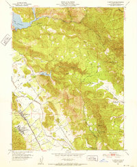
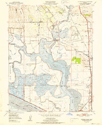 1951 Cuttings Wharf1951 Print · USGSThe Napa River delta and San Pablo Bay marshes come to life in this early 1950s survey of the California waterfront. Genealogists and historians can trace the development of Cuttings Wharf and Dutton Landing, or locate the Lachman Club among the sloughs.
 - 1951 Map of Capell Valley, 1952 Print
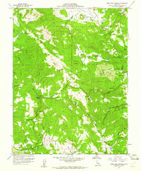
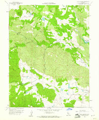
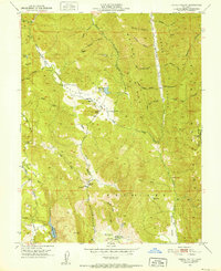 1951 Capell Valley1952 Print · USGSNapa County's upland canyons and ranching valleys are captured here during the early fifties, showing a rural landscape before modern development. Genealogists and historians can locate family landmarks like Munson Ranch, the Wooden Valley School, and the settlement at Moskowite.5 unique versions available
 - 1951 Map of Mt. Vaca, 1952 Print
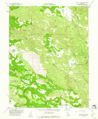
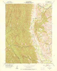 1951 Mt. Vaca1952 Print · USGSSolano County rangelands and the steep ridges of the Vaca Mountains appear here as they were in the early fifties. Local historians and genealogists can trace family holdings like Pioneer Ranch or find the former site of the Rhine School (Abandoned) along Alamo Creek.3 unique versions available
 - 1951 Map of Napa, 1952 Print
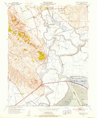
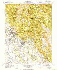
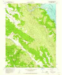
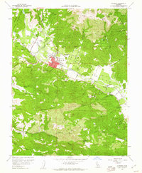
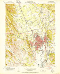 1951 Napa1952 Print · USGSThe Napa Valley landscape in the early fifties shows a region of transition between its historic adobe roots and postwar growth. Researchers can trace family sites from Vichy Springs to Oak Knoll, locating old schools like Soda Canyon School and the Tulocay Cem.6 unique versions available
 - 1951 Map of Sears Point, 1952 Print
 1951 Sears Point1952 Print · USGSThe northern edge of San Pablo Bay comes alive in the early fifties, showing a landscape of tidal sloughs and rail junctions. Genealogists and historians can trace the tracks of the Southern Pacific to settlements like Schellville, Wingo, and the Tule Vista School.5 unique versions available
 - 1951 Map of Cordelia, 1952 Print
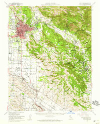
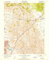 1951 Cordelia1952 Print · USGSNorth of Vallejo in the early fifties, this area shows a landscape of developing neighborhoods and heavy industry. Genealogists and historians can locate the Permanente Foundation Hospital, the St John Mine, and the rail junction at Cordelia.9 unique versions available
 - 1951 Map of Yountville, 1952 Print
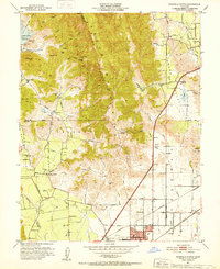
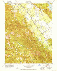
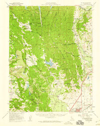
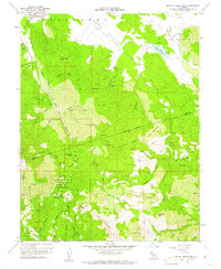
 1951 Yountville1952 Print · USGSThe Napa Valley floor and its eastern ridges appear here in the early 1950s, showing a landscape of state-run farms and mountain ranches. Researchers can trace the original Silverado Trail, the grounds of the State Veterans Home, and landmarks like Stags Leap.6 unique versions available
 - 1951 Map of Fairfield North, 1952 Print
 1951 Fairfield North1952 Print · USGSNorthern Solano County in the early fifties shows a landscape of mountain ridges and valley farms. Genealogists and historians can trace old homesteads and landmarks like the Pena House, Mankas Corner, and Suisun School.7 unique versions available
 - 1951 Map of Sonoma, 1952 Print
 1951 Sonoma1952 Print · USGSSonoma and its surrounding vineyards and thermal springs are captured in the early fifties, before modern expansion altered the valley floor. Genealogists can trace early homesteads and landmarks like the Vallejo Home State Historical Monument, Mountain Cem, and Vineburg.4 unique versions available
 - 1951 Map of Rutherford, 1952 Print
 1951 Rutherford1952 Print · USGSNapa Valley during the early fifties reveals a landscape of rural viticulture and mountain mining operations. Local researchers can trace the rail corridor through Rutherford and Oakville or locate historical sites like La Joya Quicksilver Mine and Enterprise Sch.6 unique versions available
 - 1951 Map of Mt. George, 1952 Print
 1951 Mt. George1952 Print · USGSThe Napa and Solano county highlands are captured here in the early fifties, a landscape defined by vital water reservoirs and rural estate development. Local historians can trace family-named landmarks like Chimiles Farm Center and Mt George Union Sch alongside the early fairways of the Green Valley Golf Club.5 unique versions available
 - 1951 Map of Sonoma, 1958 Print
 1951 Sonoma1958 Print · USGSWine country was already maturing in the mid-twentieth century as rail lines and early wineries shaped the valley landscape. Researchers can trace the legacy of established vineyards at Thomann Winery and Buena Vista or locate old burial grounds like Yountville Cem.3 unique versions available
 - 1951 Map of Mt. Vaca, 1959 Print
 1951 Mt. Vaca1959 Print · USGSNorthern California's agricultural valleys and ridges are captured here in the early fifties. Researchers can trace rural life through landmarks like Peña House, Mankas Corner, and schools such as Gordon Valley School.2 unique versions available
 - 1954 Map of Kenwood, 1955 Print
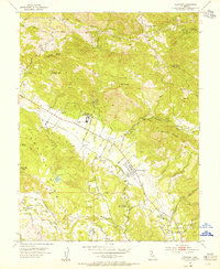 1954 Kenwood1955 Print · USGSSonoma Valley's rural character is preserved here in the mid-fifties, showing the intersection of valley ranching and early mountain industry. Researchers can trace the Northwestern Pacific Railroad Grade and locate historic landmarks like the Los Guilicos School For Girls and McCormack Ranch.7 unique versions available
 - 1954 Map of Santa Rosa, 1959 Print
 1954 Santa Rosa1959 Print · USGSSonoma County at the mid-century shows a landscape of expanding valley towns and military infrastructure. Researchers can locate the Cotati Naval Auxiliary Air Station or trace the Jack London Ranch and Penngrove rail stops.2 unique versions available
 - 1958 Map of Knoxville, 1961 Print
 1958 Knoxville1961 Print · USGSNapa County's rugged mining interior is captured in the late fifties, centered on the historic quicksilver district. Genealogists and historians can trace the footprint of the Manhattan Mine, the settlement of Knoxville, and natural landmarks like Zim Zim Falls.3 unique versions available
 - 1958 Map of Mark West Springs, 1961 Print
 1958 Mark West Springs1961 Print · USGSSonoma County hills come alive in this mid-century survey of the rugged territory between Fulton and the Napa border. Genealogists and local historians can trace family-named routes and early sites like the Petrified Forest, the Mark West Creek Rancheria, and Alpine School.3 unique versions available
 - 1958 Map of Jericho Valley, 1961 Print
 1958 Jericho Valley1961 Print · USGSLake County ranching and mining country are detailed in the late fifties, showing the rugged borderlands with Napa County. Genealogists and historians can trace family-named sites like Ink Ranch and the Red Elephant Mine alongside Amel Lake.4 unique versions available
 - 1958 Map of Chiles Valley, 1961 Print
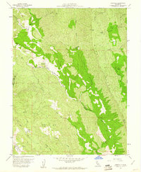
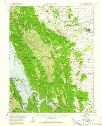
 1958 Chiles Valley1961 Print · USGSNapa County's rugged eastern highlands are captured here in the late fifties, just as the new reservoir at Lake Berryessa was reshaping the landscape. Researchers can trace early landmarks like the Chiles Grist Mill and historic local sites such as Samuel Springs and Soda Spr.8 unique versions available
 - 1958 Map of Detert Reservoir, 1961 Print
 1958 Detert Reservoir1961 Print · USGSThe Mayacamas Mountains in the late fifties remained a rugged hub of mercury and silver mining. Genealogists and industrial historians can trace the foundations of the Oat Hill Mine, Corona Mine, and Silverado Mine along the winding Old Grade.5 unique versions available
 - 1958 Map of Aetna Springs, 1961 Print
 1958 Aetna Springs1961 Print · USGSNapa County's rugged backcountry comes into focus in the late fifties, showing the historic thermal resort at Aetna Springs and the early stages of Lake Berryessa. Researchers can trace old mining operations like the Aetna Mine and remote family landmarks along Stone Corral Trail.6 unique versions available
 - 1958 Map of Calistoga, 1961 Print
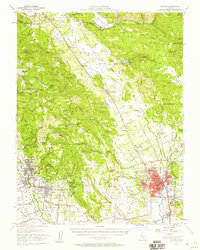
 1958 Calistoga1961 Print · USGSThe Napa Valley's agricultural and mining heritage is clearly visible in the late 1950s, centered on the community of Calistoga. Researchers can trace the rail-and-river economy through the Southern Pacific line and sites like the Bale Mill Historical Monument or the Palisade Mine.5 unique versions available
 - 1958 Map of Morgan Valley, 1962 Print
 1958 Morgan Valley1962 Print · USGSThe northern California highlands come alive in the late fifties, showing a landscape defined by active mines and sprawling family ranches. Researchers can trace the footprints of the Manhattan Mine, Rumsey Rancheria, and Hennesey Ranch among the ridges.2 unique versions available
 - 1958 Map of Santa Rosa, 1968 Print
 1958 Santa Rosa1968 Print · USGSThe North Bay and Wine Country are captured in the mid-twentieth century as the region balanced its agricultural roots with a growing military and recreational footprint. Researchers can trace the Northwestern Pacific RR through the Russian River valley or locate landmarks like the Petaluma Adobe Historical Monument and The Geysers Resort.3 unique versions available
 - 1959 Map of Lake Berryessa, 1961 Print
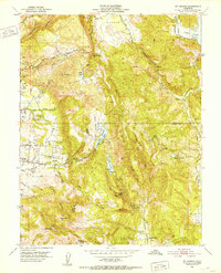
 1959 Lake Berryessa1961 Print · USGSThe Yolo and Napa County borderlands are seen here just after the completion of the Monticello Dam. Researchers can trace early recreational sites like Spanish Flat Resort and the Southern Pacific rail line through Esparto.2 unique versions available
Showing maps 1-25 of 33
Top cities of Napa County
- Napa historical maps
- American Canyon historical maps
- Calistoga historical maps
- Yountville historical maps
Frequently asked questions
- What are the different types of historical maps available for Napa County?
- What is the oldest map of Napa County?
- Where can I purchase historical maps of Napa County for my home or office?
- Where can I download high-res historical maps of Napa County?
- Are there historical topographic maps available for Napa County?
- Is there historical aerial imagery available for Napa County?
- Where are historical maps of Napa County sourced from?