1990s Maps of Napa County, California
Explore 10 historic maps of Napa County from the 1990s. These maps offer a rare glimpse into what life looked like during the 1990s — showing old roads, neighborhoods, homes, and landmarks that have changed or disappeared over time.
Whether you're researching your family's past, planning a metal detecting trip, or studying how Napa County's landscape evolved across the 1990s, these high-resolution maps are a powerful tool for exploring the history of this region.
- Focus on a specific era: All maps on this page are from the 1990s, giving you a focused view of this time period.
- See what’s changed: Compare century-old streets, trails, and buildings to today's modern landscape using overlays and satellite layers.
- Research with precision: Use these maps for genealogy, historical research, land use analysis, or educational projects.
- View, download, or print: Maps are fully viewable online in high resolution, and can be downloaded or printed for your own records.
Start exploring Napa County's history through authentic maps from the 1990s. This is your window into the past.
Napa County, CA maps
(10)- 1993 Map of Calistoga
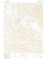 1993 Calistoga1993 Print · USGSThe northern reaches of the Napa Valley come into focus in the early nineties, centered on the historic town of Calistoga. Genealogists and historians can trace local landmarks like the Bale Grist Mill State Historical Park, Larkmead, and the Palisade Mine.
 - 1993 Map of Mount St. Helena
 1993 Mount St. Helena1993 Print · USGSThe high ridges where Sonoma, Lake, and Napa counties meet are captured here in the early nineties, showing a landscape of geothermal energy and protected wilderness. Researchers can trace historic property lines like Knights Grant and find old mining sites including Chicago Mine and Wall Street Mine.
 - 1993 Map of Detert Reservoir
 1993 Detert Reservoir1993 Print · USGSThe mining-scarred ridges of the Mayacmas Mountains come into focus in the early 1990s as they bridge Lake and Napa counties. Genealogists and historians can trace the locations of legendary quicksilver workings like the Oat Hill Mine and Silverado Mine near Table Mountain.
 - 1993 Map of Mark West Springs
 1993 Mark West Springs1993 Print · USGSSonoma County's volcanic ridges and historic land grants are captured here in the early nineties. Researchers can trace the winding Petrified Forest Road to find the Petrified Forest, the Franz Valley School, and old landmarks like Mark West Springs.2 unique versions available
 - 1997 Map of Mount Saint Helena, 1998 Print
 1997 Mount Saint Helena1998 Print · USGSThe high Mayacmas Mountains come into focus in the late nineties, showing the rugged intersection of Sonoma, Lake, and Napa counties. Researchers can trace historic mining operations at the Chicago and Helen mines or locate the Locke Cabin Site.
 - 1997 Map of Calistoga, 1998 Print
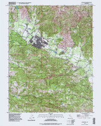 1997 Calistoga1998 Print · USGSUpper Napa Valley thrives in the late nineties as a world-renowned vineyard landscape anchored by the town of Calistoga. Researchers can trace the heritage of the regional wine economy through the Schramsberg Winery Historical Marker and Bale Grist Mill State Historical Park.
 - 1997 Map of Detert Reservoir, 1998 Print
 1997 Detert Reservoir1998 Print · USGSThe rugged mining districts of Lake and Napa counties come to life in this late twentieth-century survey. Trace the heritage of the region's mercury industry through sites like the Oat Hill Mine, Silverado Mine, and the historic town of Middletown.
 - 1998 Map of Mark West Springs, 2002 Print
 1998 Mark West Springs2002 Print · USGSThe Mayacamas Mountains in the late 1990s reveal a landscape of creek-carved valleys and rural landmarks between Santa Rosa and Calistoga. Researchers can trace local history through the Petrified Forest, find the Grave on the eastern hills, or follow Franz Valley School Road.
 - 1998 Map of Lake Berryessa, 2002 Print
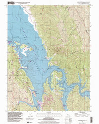 1998 Lake Berryessa2002 Print · USGSThe Napa County reservoir landscape appears in the late nineties, documenting the established resort communities along the shoreline. Trace local landmarks and public access points like Spanish Flat, the Monticello Cem, and Steele Park Resort.
 - 1998 Map of Aetna Springs, 2002 Print
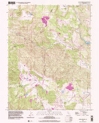 1998 Aetna Springs2002 Print · USGSNapa County’s northern interior is captured here in the late twentieth century, showing the intersection of mining history and resort life. Researchers can trace early rural life through the Aetna Mine, the Black Oak Villa (Site), and the rugged path of Stagecoach Road.
End of results
Showing maps 1-10 of 10
Top cities of Napa County
- Napa historical maps
- American Canyon historical maps
- Calistoga historical maps
- Yountville historical maps
Frequently asked questions
- What are the different types of historical maps available for Napa County?
- What is the oldest map of Napa County?
- Where can I purchase historical maps of Napa County for my home or office?
- Where can I download high-res historical maps of Napa County?
- Are there historical topographic maps available for Napa County?
- Is there historical aerial imagery available for Napa County?
- Where are historical maps of Napa County sourced from?