Old Maps of Gaviota, California for Hiking & Exploration
Hike through history with 17 historic maps of Gaviota. Explore old trails, ghost towns, and forgotten backroads — perfect for outdoor adventurers and local explorers.
- Rediscover forgotten places: Map out old mining camps, roads, and footpaths that no longer exist on modern maps.
- Layer with modern tools: Combine with LiDAR or satellite views to plan hikes through historical terrain.
- Made for exploration: Popular among hikers, overlanders, and local history lovers.
Use these maps to find adventure and explore the hidden past of Gaviota.
Gaviota, CA maps
(17)- 1942 Map of Gaviota
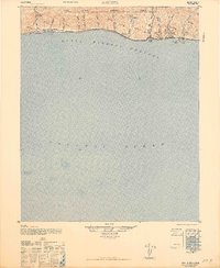
 1942 Gaviota1942 Print · USGSThe Santa Barbara coast during the early years of the war reveals a narrow corridor of railroad and ranching life between the sea and the mountains. Genealogists and researchers can trace the coastal route through Alcatraz, Tajiguas, and the strategic passage at Gaviota Pass.
 - 1943 Map of Gaviota
 1943 Gaviota1943 Print · USGSThe Santa Barbara coastline comes into sharp focus during the early 1940s, showing the narrow coastal shelf before mid-century expansion. Researchers can trace the path of the Southern Pacific railroad through Gaviota and identify historic canyons like Cañada del Capitan.
 - 1947 Map of Gaviota
 1947 Gaviota1947 Print · USGSThe Santa Barbara coastline is captured just after the war as the Southern Pacific railway and Highway 101 wind along the Pacific bluffs. Genealogists and historians can trace old coastal settlements and rail sidings like Lento, Tajiguas, and Capitan.2 unique versions available
 - 1948 Map of Santa Maria
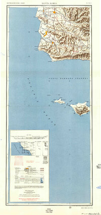
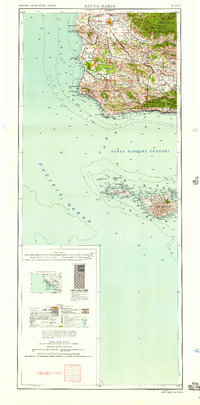
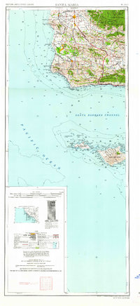
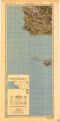 1948 Santa Maria1948 Print · USGSSanta Barbara County in the late 1940s reveals a landscape of coastal defense and valley agriculture. Genealogists and historians can trace the footprint of Camp Cooke Military Reservation or locate rural landmarks like Honda School and Betteravia.2 unique versions available
 - 1953 Map of Gaviota, 1954 Print
 1953 Gaviota1954 Print · USGSThe Santa Barbara coastline and the Santa Ynez range meet at the Gaviota Pass in the early fifties. Researchers can trace the coastal route of the Southern Pacific railroad and locate local landmarks like the Vista Del Mar Union Sch and Las Cruces.6 unique versions available
 - 1956 Map of Santa Maria, 1973 Print
 1956 Santa Maria1973 Print · USGSThe Central Coast landscape at the height of the Cold War reveals a mix of aerospace expansion and historic ranching towns. Trace the early footprint of Vandenberg AFB or locate coastal rail stops like Surf and the mission site at La Purisima Mission State Park.2 unique versions available
 - 1957 Map of Santa Maria
 1957 Santa Maria1957 Print · USGSCoastal Santa Barbara County is captured here during the mid-fifties, showing a landscape defined by military installations and petroleum production. Researchers can trace the Southern Pacific rail line and locate rural landmarks like Honda School, Betteravia, and the John Manville Plant.
 - 1958 Map of Santa Maria
 1958 Santa Maria1958 Print · USGSThe Central Coast in the mid-fifties reveals a landscape shaped by military expansion and historic ranching towns. Researchers can trace the Southern Pacific railroad through Betteravia and Guadalupe, or explore the early layout of Camp Cooke Military Reservation.
 - 1962 Map of Santa Maria
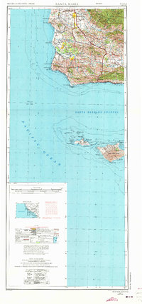
 1962 Santa Maria1962 Print · USGSCoastal Santa Barbara County and its offshore islands are shown here during the early years of the Space Age. Researchers can trace the rail corridor of the Southern Pacific or locate local landmarks like Los Coches Mine and Solvang.
 - 1966 Map of Gaviota
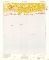
 1966 Gaviota1966 Print · USGSThe Gaviota coast of Santa Barbara County is captured here in the mid-1960s, showing the intersection of the Santa Ynez Mountains and the Pacific. Genealogists and historians can trace the paths of the Southern Pacific railroad and Highway 101 through coastal settlements like Tajiguas and Orella.
 - 1981 Map of Point Conception
 1981 Point Conception1981 Print · USGSCoastal Santa Barbara County meets the Pacific at the turn of the 1980s, revealing a landscape of mountain ridges and offshore islands. Trace the Southern Pacific rail line past Gaviota or explore the remote shores of San Miguel Island and Point Conception.
 - 1989 Map of Santa Maria, 1991 Print
 1989 Santa Maria1991 Print · USGSThe Central Coast in the late eighties reveals a landscape of massive coastal installations and deep-rooted agricultural valleys. Genealogists and researchers can trace the Southern Pacific line through Guadalupe or locate landmarks like Betteravia and the La Purisima Mission State Historical Monument.
 - 1995 Map of Gaviota, 2000 Print
 1995 Gaviota2000 Print · USGSThe Santa Barbara coastline in the mid-nineties shows a landscape defined by the rugged passage of Gaviota Pass and the Southern Pacific rail line. Genealogists and researchers can trace local landmarks like Vista Del Mar Union School and the Port Orford (Site).
 - 2012 Map of Gaviota, 2012 Print
 2012 Gaviota2012 Print · USGSCovers Gaviota, including Santa Barbara County, United States, and other nearby areas
 - 2015 Map of Gaviota, 2015 Print
 2015 Gaviota2015 Print · USGSCovers Gaviota, including Santa Barbara County, United States, and other nearby areas
 - 2018 Map of Gaviota, 2018 Print
 2018 Gaviota2018 Print · USGSCovers Gaviota, including Santa Barbara County, United States, and other nearby areas
 - 2021 Map of Gaviota, 2021 Print
 2021 Gaviota2021 Print · USGSThe coastal canyons and mountain passes of Santa Barbara County are captured here during the early 2020s. Researchers can trace historic routes like Cll Real and explore named drainages such as Cañada del Cementerio and Arroyo Honda Creek.
End of results
Showing maps 1-17 of 17
Top cities near Gaviota
- Lompoc historical maps
- Solvang historical maps
- Santa Ynez historical maps
- Buellton historical maps
- Los Olivos historical maps
- Ballard historical maps
Frequently asked questions
- What are the different types of historical maps available for Gaviota?
- What is the oldest map of Gaviota?
- Where can I purchase historical maps of Gaviota for my home or office?
- Where can I download high-res historical maps of Gaviota?
- Are there historical topographic maps available for Gaviota?
- Is there historical aerial imagery available for Gaviota?
- Where are historical maps of Gaviota sourced from?