1950s Maps of Yreka, California
Explore 4 historic maps of Yreka from the 1950s. These maps offer a rare glimpse into what life looked like during the 1950s — showing old roads, neighborhoods, homes, and landmarks that have changed or disappeared over time.
Whether you're researching your family's past, planning a metal detecting trip, or studying how Yreka's landscape evolved across the 1950s, these high-resolution maps are a powerful tool for exploring the history of this region.
- Focus on a specific era: All maps on this page are from the 1950s, giving you a focused view of this time period.
- See what’s changed: Compare century-old streets, trails, and buildings to today's modern landscape using overlays and satellite layers.
- Research with precision: Use these maps for genealogy, historical research, land use analysis, or educational projects.
- View, download, or print: Maps are fully viewable online in high resolution, and can be downloaded or printed for your own records.
Start exploring Yreka's history through authentic maps from the 1950s. This is your window into the past.
Yreka, CA maps
(4)- 1950 Map of Weed
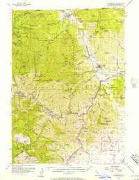
 1950 Weed1950 Print · USGSSiskiyou County and the surrounding Klamath mountains appear in the mid-century before extensive modern development. Genealogists and local historians can locate remote outposts like the Lee Brown Ranch and the specialized settlement of Darlingtonia.
 - 1954 Map of Yreka, 1957 Print
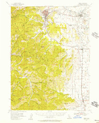 1954 Yreka1957 Print · USGSSiskiyou County during the mid-fifties is captured here as a landscape of established cattle ranching and mining tradition. Genealogists and historians can trace old homesteads and landmarks like Forest House, local schools such as Delphic School, and workings at the Pegleg Mine.3 unique versions available
 - 1955 Map of Hornbrook, 1957 Print
 1955 Hornbrook1957 Print · USGSThe Siskiyou County borderlands come to life in the mid-fifties, showing a landscape defined by the Southern Pacific rails and river-bar mining. Genealogists and historians can trace the foundations of Gottville, find the Honolulu School, or locate the numerous family-named mines like the Winget Mine.3 unique versions available
 - 1958 Map of Weed, 1963 Print
 1958 Weed1963 Print · USGSThe Northern California high country of the late fifties is defined by the towering presence of Mt Shasta and the logging railroads of the Siskiyou range. Genealogists and researchers can trace remote mining sites like the China Mine and mountain settlements such as Sawyers Bar and Seiad Valley.3 unique versions available
End of results
Showing maps 1-4 of 4
Top cities near Yreka
Frequently asked questions
- What are the different types of historical maps available for Yreka?
- What is the oldest map of Yreka?
- Where can I purchase historical maps of Yreka for my home or office?
- Where can I download high-res historical maps of Yreka?
- Are there historical topographic maps available for Yreka?
- Is there historical aerial imagery available for Yreka?
- Where are historical maps of Yreka sourced from?