1970s Maps of Yreka, California
Explore 2 historic maps of Yreka from the 1970s. These maps offer a rare glimpse into what life looked like during the 1970s — showing old roads, neighborhoods, homes, and landmarks that have changed or disappeared over time.
Whether you're researching your family's past, planning a metal detecting trip, or studying how Yreka's landscape evolved across the 1970s, these high-resolution maps are a powerful tool for exploring the history of this region.
- Focus on a specific era: All maps on this page are from the 1970s, giving you a focused view of this time period.
- See what’s changed: Compare century-old streets, trails, and buildings to today's modern landscape using overlays and satellite layers.
- Research with precision: Use these maps for genealogy, historical research, land use analysis, or educational projects.
- View, download, or print: Maps are fully viewable online in high resolution, and can be downloaded or printed for your own records.
Start exploring Yreka's history through authentic maps from the 1970s. This is your window into the past.
Yreka, CA maps
(2)- 1974 Map of Yreka NW, 1980 Print
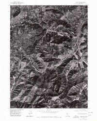 1974 Yreka NW1980 Print · USGSNorthern Siskiyou County is captured in the mid-seventies, showing the city of Yreka as it meets the foothills. Researchers can trace the path of Yreka Creek or locate landmarks like Manzanita Hill in this detailed aerial record.
 - 1979 Map of Yreka
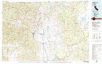 1979 Yreka1979 Print · USGSSiskiyou County in the late seventies is a rugged landscape of deep river canyons and high mountain valleys where logging and mining history meet. Genealogists and researchers can trace old rail stops and mining sites like Klamathon, Negro Boy Mine, and the settlement of Mugginsville.
End of results
Showing maps 1-2 of 2
Top cities near Yreka
Frequently asked questions
- What are the different types of historical maps available for Yreka?
- What is the oldest map of Yreka?
- Where can I purchase historical maps of Yreka for my home or office?
- Where can I download high-res historical maps of Yreka?
- Are there historical topographic maps available for Yreka?
- Is there historical aerial imagery available for Yreka?
- Where are historical maps of Yreka sourced from?