2000-2009 Maps of Yreka, California
Explore 3 historic maps of Yreka from 2000-2009. These maps offer a rare glimpse into what life looked like during the 2000s — showing old roads, neighborhoods, homes, and landmarks that have changed or disappeared over time.
Whether you're researching your family's past, planning a metal detecting trip, or studying how Yreka's landscape evolved across the 2000s, these high-resolution maps are a powerful tool for exploring the history of this region.
- Focus on a specific era: All maps on this page are from the 2000s, giving you a focused view of this time period.
- See what’s changed: Compare century-old streets, trails, and buildings to today's modern landscape using overlays and satellite layers.
- Research with precision: Use these maps for genealogy, historical research, land use analysis, or educational projects.
- View, download, or print: Maps are fully viewable online in high resolution, and can be downloaded or printed for your own records.
Start exploring Yreka's history through authentic maps from the 2000s. This is your window into the past.
Yreka, CA maps
(3)- 2001 Map of Yreka, 2004 Print
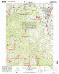 2001 Yreka2004 Print · USGSThe northern California landscape at the turn of the millennium shows the intersection of the Klamath National Forest and the historic city of Yreka. Genealogists and historians can trace the town's layout near Evergreen Cemetery and the Siskiyou County Courthouse.2 unique versions available
 - 2001 Map of Hawkinsville, 2004 Print
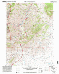 2001 Hawkinsville2004 Print · USGSSiskiyou County at the start of the millennium reveals a rugged landscape of mining history and river confluences. Researchers can trace the heritage of the Negro Boy Mine and Union Mine or locate the small settlements of Riverview and Hawkinsville.
 - 2001 Map of Badger Mountain, 2004 Print
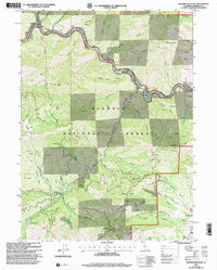 2001 Badger Mountain2004 Print · USGSSiskiyou County's gold-bearing river canyons and forest peaks are captured here in the early 2000s, reflecting a century of extraction. Genealogists and historians can locate former communities like Gottville or trace the Siskiyou Mine and Kanaka Cem among the many riverside bars.
End of results
Showing maps 1-3 of 3
Top cities near Yreka
Frequently asked questions
- What are the different types of historical maps available for Yreka?
- What is the oldest map of Yreka?
- Where can I purchase historical maps of Yreka for my home or office?
- Where can I download high-res historical maps of Yreka?
- Are there historical topographic maps available for Yreka?
- Is there historical aerial imagery available for Yreka?
- Where are historical maps of Yreka sourced from?