1980s Maps of Yreka, California
Explore 4 historic maps of Yreka from the 1980s. These maps offer a rare glimpse into what life looked like during the 1980s — showing old roads, neighborhoods, homes, and landmarks that have changed or disappeared over time.
Whether you're researching your family's past, planning a metal detecting trip, or studying how Yreka's landscape evolved across the 1980s, these high-resolution maps are a powerful tool for exploring the history of this region.
- Focus on a specific era: All maps on this page are from the 1980s, giving you a focused view of this time period.
- See what’s changed: Compare century-old streets, trails, and buildings to today's modern landscape using overlays and satellite layers.
- Research with precision: Use these maps for genealogy, historical research, land use analysis, or educational projects.
- View, download, or print: Maps are fully viewable online in high resolution, and can be downloaded or printed for your own records.
Start exploring Yreka's history through authentic maps from the 1980s. This is your window into the past.
Yreka, CA maps
(4)- 1983 Map of Hawkinsville, 1984 Print
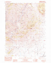 1983 Hawkinsville1984 Print · USGSNorthern California's mining and river landscapes are captured here in the early eighties as the Shasta Valley meets the forest. Researchers can trace historical extraction sites like the Negro Boy Mine and Union Mine or follow the route of the Southern Pacific railroad.
 - 1984 Map of Yreka
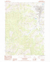 1984 Yreka1984 Print · USGSSiskiyou County's seat at the edge of the Shasta Valley is captured here in the early 1980s, balancing timber, mining, and mountain living. Local historians can trace the rail lines of the Yreka Western RR and locate sites like Evergreen Cemetery and the Scorpion Mine.
 - 1984 Map of Montague
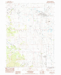 1984 Montague1984 Print · USGSSiskiyou County in the mid-1980s was a landscape defined by the railroads and rivers of the Shasta Valley. Genealogists and historians can trace family locations near the Montague Cem, follow the Southern Pacific line, or explore the area around Butcher Hill.2 unique versions available
 - 1984 Map of Badger Mtn.
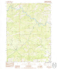 1984 Badger Mtn.1984 Print · USGSSiskiyou County's Klamath River corridor is captured here in the mid-1980s, documenting a landscape of steep gulches and historic gold-bearing bars. Genealogists and historians can locate former community hubs like Gottville and the Honolulu Sch (Site), or trace mining operations at the Indian Girl Mine.
End of results
Showing maps 1-4 of 4
Top cities near Yreka
Frequently asked questions
- What are the different types of historical maps available for Yreka?
- What is the oldest map of Yreka?
- Where can I purchase historical maps of Yreka for my home or office?
- Where can I download high-res historical maps of Yreka?
- Are there historical topographic maps available for Yreka?
- Is there historical aerial imagery available for Yreka?
- Where are historical maps of Yreka sourced from?