1920s Maps of Yreka, California
Explore 3 historic maps of Yreka from the 1920s. These maps offer a rare glimpse into what life looked like during the 1920s — showing old roads, neighborhoods, homes, and landmarks that have changed or disappeared over time.
Whether you're researching your family's past, planning a metal detecting trip, or studying how Yreka's landscape evolved across the 1920s, these high-resolution maps are a powerful tool for exploring the history of this region.
- Focus on a specific era: All maps on this page are from the 1920s, giving you a focused view of this time period.
- See what’s changed: Compare century-old streets, trails, and buildings to today's modern landscape using overlays and satellite layers.
- Research with precision: Use these maps for genealogy, historical research, land use analysis, or educational projects.
- View, download, or print: Maps are fully viewable online in high resolution, and can be downloaded or printed for your own records.
Start exploring Yreka's history through authentic maps from the 1920s. This is your window into the past.
Yreka, CA maps
(3)- 1922 Map of Shasta Valley Sheet No 4
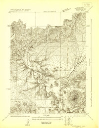 1922 Shasta Valley Sheet No 41922 Print · USGSSiskiyou County's high-desert landscape appears in great detail in the early 1920s as irrigation and power projects began to reshape the valley. Genealogists and local historians can pinpoint the exact sites of the Dwinell School, Delphic School, and the rail junction at Montague.
 - 1922 Map of Shasta Valley Sheet No 3
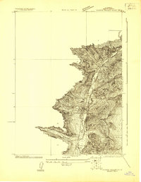 1922 Shasta Valley Sheet No 31922 Print · USGSYreka and the western Shasta Valley are shown in detail during the early 1920s as the local irrigation network was being established. Researchers can locate specific structures and civic sites like Greenhorn School, the town Cem, and the winding Yreka Ditch.
 - 1922 Map of Shasta Valley Sheet No 3 S
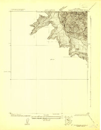 1922 Shasta Valley Sheet No 3 S1922 Print · USGSIn the early 1920s, the irrigation and water networks of Siskiyou County were undergoing significant engineering. Researchers can trace the path of the Yreka Ditch alongside Yreka Creek and locate early benchmarks like BM 2838.
End of results
Showing maps 1-3 of 3
Top cities near Yreka
Frequently asked questions
- What are the different types of historical maps available for Yreka?
- What is the oldest map of Yreka?
- Where can I purchase historical maps of Yreka for my home or office?
- Where can I download high-res historical maps of Yreka?
- Are there historical topographic maps available for Yreka?
- Is there historical aerial imagery available for Yreka?
- Where are historical maps of Yreka sourced from?