1920s Maps of Sonoma County, California
Explore 5 historic maps of Sonoma County from the 1920s. These maps offer a rare glimpse into what life looked like during the 1920s — showing old roads, neighborhoods, homes, and landmarks that have changed or disappeared over time.
Whether you're researching your family's past, planning a metal detecting trip, or studying how Sonoma County's landscape evolved across the 1920s, these high-resolution maps are a powerful tool for exploring the history of this region.
- Focus on a specific era: All maps on this page are from the 1920s, giving you a focused view of this time period.
- See what’s changed: Compare century-old streets, trails, and buildings to today's modern landscape using overlays and satellite layers.
- Research with precision: Use these maps for genealogy, historical research, land use analysis, or educational projects.
- View, download, or print: Maps are fully viewable online in high resolution, and can be downloaded or printed for your own records.
Start exploring Sonoma County's history through authentic maps from the 1920s. This is your window into the past.
Sonoma County, CA maps
(5)- 1920 Map of Healdsburg
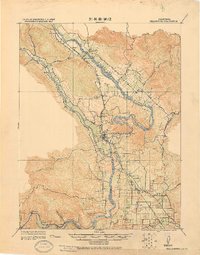 1920 Healdsburg1920 Print · USGSThe Russian River valley in the early twentieth century was a landscape of expanding viticulture and rail transit. Genealogists and historians can trace the old depots and homesteads from Geyserville to Windsor, finding specific landmarks like the Orphans Home and Olive Hill Cem.
 - 1921 Map of Skaggs
 1921 Skaggs1921 Print · USGSCoastal Sonoma County is captured here in the early twenties, showing a landscape defined by remote mountain ranches and nascent rail towns. Researchers can locate family landmarks like Soules Ranch and Nobles Ranch or trace the N. W. P. R. R. near Guerneville.
 - 1921 Map of Kelseyville
 1921 Kelseyville1921 Print · USGSNorthern California's thermal springs and mining districts are in full view in this early twentieth-century survey of Lake and Sonoma counties. Researchers can trace historic ranch boundaries like Moulton Ranch or locate vanished operations at the Cloverdale Quicksilver Mine and the Geyser Hotel.
 - 1921 Map of Plantation
 1921 Plantation1921 Print · USGSCoastal Sonoma County in the early twenties shows a landscape of remote ranches and maritime landings. Genealogists can locate family landmarks like Ohlson Ranch or Tabers Ranch and trace the old coastal post office at Plantation PO.
 - 1927 Map of Calistoga
 1927 Calistoga1927 Print · USGSUpper Napa Valley and the surrounding peaks come alive in this 1920s tactical survey. Genealogists and researchers can trace the early mercury industry at the Oat Hill Mine, locate family roots near Langstry Ranch, or follow the old Southern Pacific line through Larkmead and Bale.2 unique versions available
End of results
Showing maps 1-5 of 5
Top cities of Sonoma County
- Santa Rosa historical maps
- Petaluma historical maps
- Rohnert Park historical maps
- Windsor historical maps
- Villa Grande historical maps
- Healdsburg historical maps
See more
Frequently asked questions
- What are the different types of historical maps available for Sonoma County?
- What is the oldest map of Sonoma County?
- Where can I purchase historical maps of Sonoma County for my home or office?
- Where can I download high-res historical maps of Sonoma County?
- Are there historical topographic maps available for Sonoma County?
- Is there historical aerial imagery available for Sonoma County?
- Where are historical maps of Sonoma County sourced from?