1930s Maps of Sonoma County, California
Explore 3 historic maps of Sonoma County from the 1930s. These maps offer a rare glimpse into what life looked like during the 1930s — showing old roads, neighborhoods, homes, and landmarks that have changed or disappeared over time.
Whether you're researching your family's past, planning a metal detecting trip, or studying how Sonoma County's landscape evolved across the 1930s, these high-resolution maps are a powerful tool for exploring the history of this region.
- Focus on a specific era: All maps on this page are from the 1930s, giving you a focused view of this time period.
- See what’s changed: Compare century-old streets, trails, and buildings to today's modern landscape using overlays and satellite layers.
- Research with precision: Use these maps for genealogy, historical research, land use analysis, or educational projects.
- View, download, or print: Maps are fully viewable online in high resolution, and can be downloaded or printed for your own records.
Start exploring Sonoma County's history through authentic maps from the 1930s. This is your window into the past.
Sonoma County, CA maps
(3)- 1933 Map of Healdsburg
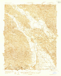 1933 Healdsburg1933 Print · USGSSonoma County's wine and river country comes alive in the early 1930s, showing the early footprints of HEALDSBURG and Geyserville. Researchers can trace the Northwestern Pacific rail line to vanished sidings and schools like Grape Sch and Sotoyome Sch.
 - 1935 Map of Sebastopol
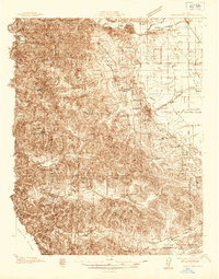 1935 Sebastopol1935 Print · USGSThe Sonoma County hills and the Gold Ridge fruit district are captured here in the mid-1930s, just as the regional rail network still connected small agricultural hamlets. Genealogists can trace family footprints at Watson Sch, Two Rock Ch, and the rural community of Bloomfield.
 - 1938 Map of Hopland
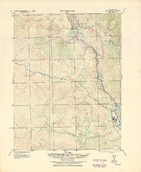 1938 Hopland1938 Print · USGSNorthern California’s Russian River valley is captured here in the 1920s, showing the early rail-and-road network between Hopland and Cloverdale. Trace old rail stops like Thorn Siding and historic locations such as Duncan Springs and Preston.
End of results
Showing maps 1-3 of 3
Top cities of Sonoma County
- Santa Rosa historical maps
- Petaluma historical maps
- Rohnert Park historical maps
- Windsor historical maps
- Villa Grande historical maps
- Healdsburg historical maps
See more
Frequently asked questions
- What are the different types of historical maps available for Sonoma County?
- What is the oldest map of Sonoma County?
- Where can I purchase historical maps of Sonoma County for my home or office?
- Where can I download high-res historical maps of Sonoma County?
- Are there historical topographic maps available for Sonoma County?
- Is there historical aerial imagery available for Sonoma County?
- Where are historical maps of Sonoma County sourced from?