1940s Maps of Sonoma County, California
Explore 39 historic maps of Sonoma County from the 1940s. These maps offer a rare glimpse into what life looked like during the 1940s — showing old roads, neighborhoods, homes, and landmarks that have changed or disappeared over time.
Whether you're researching your family's past, planning a metal detecting trip, or studying how Sonoma County's landscape evolved across the 1940s, these high-resolution maps are a powerful tool for exploring the history of this region.
- Focus on a specific era: All maps on this page are from the 1940s, giving you a focused view of this time period.
- See what’s changed: Compare century-old streets, trails, and buildings to today's modern landscape using overlays and satellite layers.
- Research with precision: Use these maps for genealogy, historical research, land use analysis, or educational projects.
- View, download, or print: Maps are fully viewable online in high resolution, and can be downloaded or printed for your own records.
Start exploring Sonoma County's history through authentic maps from the 1940s. This is your window into the past.
Sonoma County, CA maps
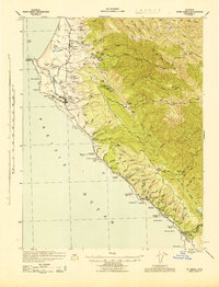
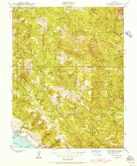
(39)- 1940 Map of Healdsburg
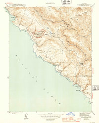
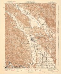 1940 Healdsburg1940 Print · USGSSonoma County's wine and timber country is captured here just before the mid-century, following the winding Russian River through thriving valley towns. Genealogists can locate family-named landmarks and rural schoolhouses like Guilford Sch, Lytton Sch, and the Oak Mound Cem.3 unique versions available
 - 1942 Map of Mare Island
 1942 Mare Island1942 Print · USGSThe northern reaches of San Pablo Bay come alive in this wartime survey, showing a landscape of vital naval yards and marshland agriculture. Genealogists and historians can trace rail depots like Napa Junction, rural landmarks like American Canyon School, and the industrial waterfronts of Vallejo and Oleum.
 - 1942 Map of Sebastopol
 1942 Sebastopol1942 Print · USGSWestern Sonoma County comes into focus in the early 1940s, showing a landscape defined by apple orchards and redwood groves. Genealogists can trace family footprints through rural sites like Gold Ridge Sch, the Northwestern Pacific RR line, and Bohemian Grove.3 unique versions available
 - 1942 Map of Sonoma
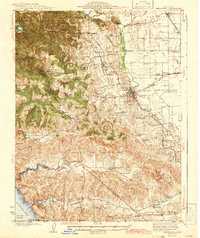
 1942 Sonoma1942 Print · USGSThe Napa and Sonoma valleys are captured here during the early 1940s, showing the established rail and agricultural networks of the North Bay. Researchers can trace historic landmarks like the Veterans Home, the Quick Silver Mine, and early vineyard sites at Zinfandel and Rutherford.
 - 1942 Map of Petaluma
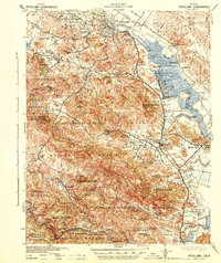 1942 Petaluma1942 Print · USGSThe Marin and Sonoma county line runs through this early 1940s landscape of tidal marshes and ranch lands. Genealogists can trace family names at Mt Oliver Cemetery or find historic rural institutions like the Olompali School and St Vincent Station.
 - 1942 Map of Bodega Head, 1956 Print
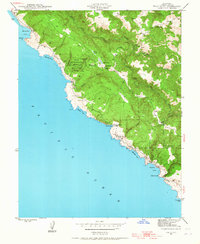
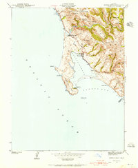 1942 Bodega Head1956 Print · USGSThe Sonoma coast during the early 1940s reveals a landscape of sheltered harbors and high coastal ridges. Genealogists and historians can trace the foundations of Bodega Bay, locate the Ocean View Sch, and explore landmarks from Arched Rock Beach to Swallow City.3 unique versions available
 - 1942 Map of Arched Rock, 1956 Print
 1942 Arched Rock1956 Print · USGSThe Sonoma coast at the start of the 1940s reveals a wild landscape of deep gulches and rocky outcroppings. Researchers can trace the rugged shoreline from Arched Rock to the Russian River and explore the hills surrounding Little Black Mountain.3 unique versions available
 - 1943 Map of Point Arena
 1943 Point Arena1943 Print · USGSThe Mendocino coast in the early 1940s reveals a landscape of isolated ranching and seafaring communities. Genealogists and local historians can trace family holdings from the Iverson Indian Rancheria to the Bourns Family Cem and the Seaside School.2 unique versions available
 - 1943 Map of Tombs Creek
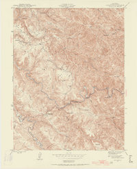
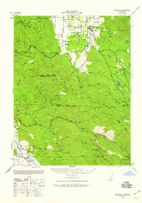
 1943 Tombs Creek1943 Print · USGSSonoma County ranching and timber lands are documented here during the mid-1940s. Genealogists and historians can trace family properties like Wickersham Ranch and Lee Nobles Ranch across ridges such as Sheep Repose Ridge.
 - 1943 Map of Calistoga, 1955 Print
 1943 Calistoga1955 Print · USGSUpper Napa Valley and the rugged Lake County border are captured here during the 1940s, a period defined by mercury mining and early tourism. Researchers can trace family-named landmarks and industrial sites like the Oat Hill Mine, Mark West Springs, and the Petrified Forest.
 - 1943 Map of Stewarts Point, 1956 Print
 1943 Stewarts Point1956 Print · USGSCoastal Sonoma County appears here during the mid-1940s, highlighting a landscape of steep ridges and maritime landings. Researchers can trace old coastal settlements like Stewarts Point and Del Mar Landing or explore the rugged inland valleys of the Wheatfield Fork Gualala River.3 unique versions available
 - 1943 Map of Plantation, 1956 Print
 1943 Plantation1956 Print · USGSThe Sonoma coast during the early 1940s reveals a network of small schoolhouses and landings before significant modern development. Genealogists can locate family-named landmarks and rural hubs like Plantation, Stillwater Cove Sch, and Walsh Landing.3 unique versions available
 - 1943 Map of Cazadero, 1956 Print
 1943 Cazadero1956 Print · USGSThe Sonoma County redwoods and canyon ranchlands are captured here during the early 1940s. Local researchers can trace family holdings like Luttrell Ranch and Doelger Ranch or locate the rural Montgomery Sch and Cazadero post office.3 unique versions available
 - 1943 Map of Annapolis, 1956 Print
 1943 Annapolis1956 Print · USGSCoastal Sonoma County ranching and rural life are preserved here just before the mid-century, centered on the settlement of Annapolis. Genealogists and historians can trace family holdings like Evans Ranch or locate the Horicon Sch and the Stewarts Point Rancheria.2 unique versions available
 - 1943 Map of Duncans Mills, 1956 Print
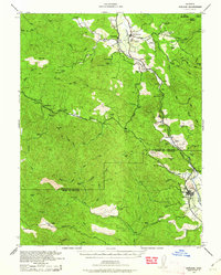
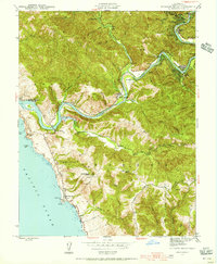 1943 Duncans Mills1956 Print · USGSThe Russian River canyon meets the Pacific in the 1940s, showing a landscape of riverside camps and coastal ranches. Trace the locations of Ocean View Sch, the settlement at Jenner, and the historic Duncans Mills river bend.2 unique versions available
 - 1943 Map of Skaggs Springs, 1956 Print
 1943 Skaggs Springs1956 Print · USGSSonoma County's backcountry appears here in the early 1940s, showing a network of ranchlands and remote springs before later water projects changed the landscape. Genealogists and hikers can trace old family holdings like Baxter Ranch and Wallers or locate Skaggs Springs and the heights of Bummer Pk.
 - 1943 Map of Fort Ross, 1958 Print
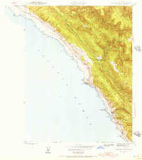
 1943 Fort Ross1958 Print · USGSCoastal Sonoma County is captured during the early 1940s, showing the ridge-top ranches and early mining sites overlooking the Pacific. Family historians can trace holdings like Seafeldt Ranch, find the Creighton Ridge Sch, and locate the Layton Mine.2 unique versions available
 - 1943 Map of Kelseyville, 1959 Print
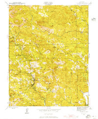
 1943 Kelseyville1959 Print · USGSIn the early 1940s, this region of Lake and Sonoma counties was a mosaic of active ranching and mountain retreats. Researchers can trace family-named lands like Fifield Ranch, locate the Socrates Mine, or find the historic Geyser Resort and Mountain School.
 - 1943 Map of Hopland, 1960 Print
 1943 Hopland1960 Print · USGSMendocino County ranching and the Russian River valley are captured here in the early 1940s as the rail and road networks matured. Researchers can trace family-named lands like McDowell Ranch, the Nacomis Indian Rancheria, and the operations at Thorn Siding.
 - 1943 Map of Ornbaun, 1961 Print
 1943 Ornbaun1961 Print · USGSNorthern California ranching and early resort history are documented here in the early 1940s along the Mendocino-Sonoma border. Genealogists can trace family holdings like Zeni Ranch and Rickard Ranch or locate the site of the Old Ornbaun Hot Springs.
 - 1944 Map of Santa Rosa
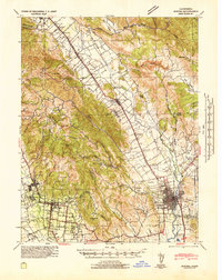
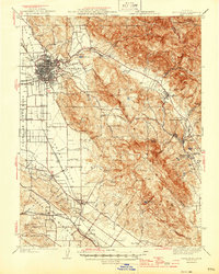 1944 Santa Rosa1944 Print · USGSSonoma County transitions from its early land-grant heritage to a mid-century agricultural hub in the years following the 1942 revision. Genealogists and researchers can locate numerous country schools and family-linked landmarks like Sonoma State Home, Adobe Fort, and Grange Hall.2 unique versions available
 - 1944 Map of Fort Ross
 1944 Fort Ross1944 Print · USGSCoastal Sonoma County appears at the height of the Second World War, showing the transition from frontier industry to historic preservation. Genealogists and historians can locate family landmarks like Seafeldt Ranch, the Seaview Cem, and the Murphy Mill (Abandoned).2 unique versions available
 - 1944 Map of Annapolis
 1944 Annapolis1944 Print · USGSNorthwestern Sonoma County ranching and timber lands are detailed in the 1940s, highlighting the Gualala River forks. Genealogists can trace family holdings like Noble Ranch or Taber Ranch and find local landmarks such as Horicon Sch.2 unique versions available
 - 1944 Map of Plantation
 1944 Plantation1944 Print · USGSThe Sonoma coast in the mid-1940s was a landscape of remote schoolhouses and small maritime landings. Researchers can trace rural life at Plantation and Ocean Cove or locate family-named landmarks like Phillips and the Fort Ross Sch.2 unique versions available
 - 1944 Map of Bodega Head
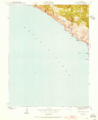
 1944 Bodega Head1944 Print · USGSThe Sonoma coast at the height of the Second World War shows a landscape of quiet harbors and remote coastal gulches. Researchers can trace the layout of Bodega Bay, locate the Ocean View Sch, and explore the terrain around Mount Roscoe and Swallow City.3 unique versions available
Showing maps 1-25 of 39
Top cities of Sonoma County
- Santa Rosa historical maps
- Petaluma historical maps
- Rohnert Park historical maps
- Windsor historical maps
- Villa Grande historical maps
- Healdsburg historical maps
See more
Frequently asked questions
- What are the different types of historical maps available for Sonoma County?
- What is the oldest map of Sonoma County?
- Where can I purchase historical maps of Sonoma County for my home or office?
- Where can I download high-res historical maps of Sonoma County?
- Are there historical topographic maps available for Sonoma County?
- Is there historical aerial imagery available for Sonoma County?
- Where are historical maps of Sonoma County sourced from?