1970s Maps of Sonoma County, California
Explore 12 historic maps of Sonoma County from the 1970s. These maps offer a rare glimpse into what life looked like during the 1970s — showing old roads, neighborhoods, homes, and landmarks that have changed or disappeared over time.
Whether you're researching your family's past, planning a metal detecting trip, or studying how Sonoma County's landscape evolved across the 1970s, these high-resolution maps are a powerful tool for exploring the history of this region.
- Focus on a specific era: All maps on this page are from the 1970s, giving you a focused view of this time period.
- See what’s changed: Compare century-old streets, trails, and buildings to today's modern landscape using overlays and satellite layers.
- Research with precision: Use these maps for genealogy, historical research, land use analysis, or educational projects.
- View, download, or print: Maps are fully viewable online in high resolution, and can be downloaded or printed for your own records.
Start exploring Sonoma County's history through authentic maps from the 1970s. This is your window into the past.
Sonoma County, CA maps
(12)- 1972 Map of Bodega Head, 1974 Print
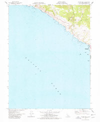
 1972 Bodega Head1974 Print · USGSThe Sonoma coastline and the geological seam of the San Andreas Rift Zone are captured here in the early seventies. Local historians and researchers can trace the coastal developments at Bodega Bay, the scientific footprint of the University of California Marine Laboratory, and landmarks like Bodega Rock.2 unique versions available
 - 1972 Map of Healdsburg, 1975 Print
 1972 Healdsburg1975 Print · USGSNorthern California wine country and the lower Lake County basins appear here during the early seventies. Trace the Northwestern Pacific rail line and discover foothill communities like Middletown and Loch Lomond.2 unique versions available
 - 1977 Map of Arched Rock, 1978 Print
 1977 Arched Rock1978 Print · USGSThe Sonoma coast in the late seventies is defined by the dramatic meeting of the Russian River and the sea. Researchers can trace the winding Meyers Grade Road and identify coastal landmarks like Arched Rock and Goat Rock Beach.2 unique versions available
 - 1977 Map of Annapolis, 1978 Print
 1977 Annapolis1978 Print · USGSCoastal Sonoma County in the mid-seventies is defined by the sharp geology of the San Andreas Rift Zone and the surrounding timbered ridges. Genealogists and local historians can locate the Stewarts Point Rancheria, the Sugarloaf Cem, and the rural Horicon Sch.3 unique versions available
 - 1977 Map of Gualala, 1978 Print
 1977 Gualala1978 Print · USGSThe Mendocino coast in the late seventies reveals a landscape of timber mills and maritime landings. Trace family roots at Bourn Cem and Seaside Sch, or explore the old sites of Anchor Bay and Gualala.
 - 1977 Map of Plantation, 1978 Print
 1977 Plantation1978 Print · USGSThe Sonoma coastline and the deep rift of the San Andreas fault define this landscape during the late seventies. Researchers can trace historic local sites like Plantation, the Fort Ross School, and the remote Ruoff Cem along the coastal ridges.2 unique versions available
 - 1978 Map of Cazadero
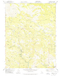 1978 Cazadero1978 Print · USGSSonoma County's redwood canyons and upland ranches are captured here in the late seventies. Researchers can trace historic family holdings like Lions Head Ranch and explore protected groves at Armstrong Redwoods State Reserve.
 - 1978 Map of Fort Ross
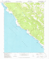
 1978 Fort Ross1978 Print · USGSCoastal Sonoma County is shown in detail during the late 1970s, from the wave-swept Fort Ross Reef to the high interior ridgelines. Genealogists and historians can trace local landmarks like Seaview Cem, the historic Call Ranch, and the winding Meyers Grade Road.2 unique versions available
 - 1978 Map of Stewarts Point
 1978 Stewarts Point1978 Print · USGSSonoma County's northern coast is shown here in the late seventies, where the massive San Andreas Fault dictates the jagged landscape. Researchers can locate the small coastal settlement of Stewarts Point, trace the Annapolis Road to Annapolis, or identify local burial sites at the Cemetery.
 - 1978 Map of Tombs Creek
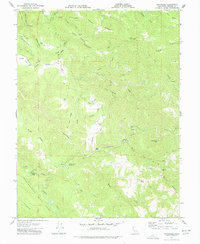
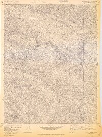
 1978 Tombs Creek1978 Print · USGSNorthern Sonoma County ranchlands and rugged ridges are captured here in the late seventies. Researchers can trace historic family-named landmarks and remote sites like Wickersham Ranch, Quicksilver Flat, and Panther Den.
 - 1978 Map of Skaggs Springs
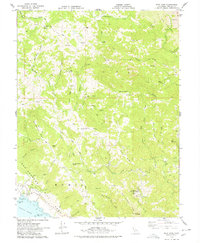
 1978 Skaggs Springs1978 Print · USGSSonoma County is shown during a transformative era in the late seventies as the valley floor was being prepared for reservoir inundation. Researchers can trace the original topography before the flooding of Lake Sonoma, including Skaggs Springs and the early Warm Springs Dam.3 unique versions available
 - 1979 Map of Duncans Mills
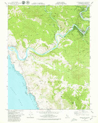 1979 Duncans Mills1979 Print · USGSThe Sonoma coast and the lower reaches of the Russian River are captured here in the late 1970s. Researchers can trace the river's path through old settlements like Duncans Mills and Monte Rio or locate coastal landmarks from Penny Island to Duncans Point.2 unique versions available
End of results
Showing maps 1-12 of 12
Top cities of Sonoma County
- Santa Rosa historical maps
- Petaluma historical maps
- Rohnert Park historical maps
- Windsor historical maps
- Villa Grande historical maps
- Healdsburg historical maps
See more
Frequently asked questions
- What are the different types of historical maps available for Sonoma County?
- What is the oldest map of Sonoma County?
- Where can I purchase historical maps of Sonoma County for my home or office?
- Where can I download high-res historical maps of Sonoma County?
- Are there historical topographic maps available for Sonoma County?
- Is there historical aerial imagery available for Sonoma County?
- Where are historical maps of Sonoma County sourced from?