1930s Maps of Tehama County, California
Explore 5 historic maps of Tehama County from the 1930s. These maps offer a rare glimpse into what life looked like during the 1930s — showing old roads, neighborhoods, homes, and landmarks that have changed or disappeared over time.
Whether you're researching your family's past, planning a metal detecting trip, or studying how Tehama County's landscape evolved across the 1930s, these high-resolution maps are a powerful tool for exploring the history of this region.
- Focus on a specific era: All maps on this page are from the 1930s, giving you a focused view of this time period.
- See what’s changed: Compare century-old streets, trails, and buildings to today's modern landscape using overlays and satellite layers.
- Research with precision: Use these maps for genealogy, historical research, land use analysis, or educational projects.
- View, download, or print: Maps are fully viewable online in high resolution, and can be downloaded or printed for your own records.
Start exploring Tehama County's history through authentic maps from the 1930s. This is your window into the past.
Tehama County, CA maps
(5)- 1931 Map of Hoaglin
 1931 Hoaglin1931 Print · USGSThe Trinity and Van Duzen river systems define this high country during the early 1930s, when remote ranches and forest stations provided the primary human footprint. Researchers can trace family-named sites like Haine Ranch and Blossom Cabin, or locate the isolated Lake Mtn Sch.
 - 1932 Map of Olinda
 1932 Olinda1932 Print · USGSNorthern Orange County comes to life in the early thirties as citrus groves and rail lines shaped the local economy. Trace the early development of Yorba Linda and Placentia or follow the historic tracks of the Pacific Electric.
 - 1935 Map of Hoaglin
 1935 Hoaglin1935 Print · USGSTrinity and Mendocino counties are captured here in the mid-1930s, documenting a landscape of isolated valleys and mountain ranches. Researchers can trace family homesteads like Russ Place and Shannon Place or locate early schools including Cover Sch and Lake Mtn Sch.3 unique versions available
 - 1935 Map of Paynes Creek
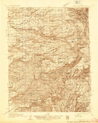 1935 Paynes Creek1935 Print · USGSUpper Tehama County in the mid-thirties was a hub of mountain industry and early hydroelectric power. Researchers can trace historic family holdings like the Facht Ranch and Wilson Ranch or locate vanished sites like the Forward Mill Camp Forward and Sierra Sch.
 - 1935 Map of Olinda
 1935 Olinda1935 Print · USGSNorthern Orange County appears here in the mid-thirties as a landscape of citrus groves and competing rail lines. Trace early property boundaries and transit routes like the Union Pacific through Yorba Linda, Carlton, and Olinda.
End of results
Showing maps 1-5 of 5
Top cities of Tehama County
- Red Bluff historical maps
- Corning historical maps
- Los Molinos historical maps
- Rancho Tehama Reserve historical maps
- Tehama historical maps
- Vina historical maps
See more
Frequently asked questions
- What are the different types of historical maps available for Tehama County?
- What is the oldest map of Tehama County?
- Where can I purchase historical maps of Tehama County for my home or office?
- Where can I download high-res historical maps of Tehama County?
- Are there historical topographic maps available for Tehama County?
- Is there historical aerial imagery available for Tehama County?
- Where are historical maps of Tehama County sourced from?