1980s Maps of Tehama County, California
Explore 24 historic maps of Tehama County from the 1980s. These maps offer a rare glimpse into what life looked like during the 1980s — showing old roads, neighborhoods, homes, and landmarks that have changed or disappeared over time.
Whether you're researching your family's past, planning a metal detecting trip, or studying how Tehama County's landscape evolved across the 1980s, these high-resolution maps are a powerful tool for exploring the history of this region.
- Focus on a specific era: All maps on this page are from the 1980s, giving you a focused view of this time period.
- See what’s changed: Compare century-old streets, trails, and buildings to today's modern landscape using overlays and satellite layers.
- Research with precision: Use these maps for genealogy, historical research, land use analysis, or educational projects.
- View, download, or print: Maps are fully viewable online in high resolution, and can be downloaded or printed for your own records.
Start exploring Tehama County's history through authentic maps from the 1980s. This is your window into the past.
Tehama County, CA maps
(24)- 1980 Map of Chico
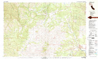
 1980 Chico1980 Print · USGSButte County and the Sierra foothills are shown here in the 1980s as the region's water and timber economies matured. Genealogists and researchers can trace old land grants like Rancho Capay or locate mountain mining sites and settlements such as Cherokee, Magalia, and the Big Bend Mine.2 unique versions available
 - 1981 Map of Ono
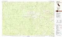
 1981 Ono1981 Print · USGSWestern Shasta County is captured here in the early eighties, centered on the community of Ono and the Bald Hills. Researchers can trace old mining sites like the Blue Gravel Mine and find local landmarks including the Cem and Gas Point.2 unique versions available
 - 1981 Map of North Yolla Bolly
 1981 North Yolla Bolly1981 Print · USGSHigh-country ridges and wilderness basins dominate this corner of the Trinity and Mendocino forests in the early eighties. Researchers can locate remote outposts like the Saddle Camp Forest Service Station, the Tomhead Mine, and the Weston Ranch.
 - 1981 Map of Beegum
 1981 Beegum1981 Print · USGSThe remote borderlands of Tehama, Shasta, and Trinity counties are captured in the early eighties as a landscape of isolated ranching and federal forestry. Researchers can trace family-named sites like Williams Ranch, find the local Cem, or locate the Chrome Mine (Site).
 - 1981 Map of Pony Buck Peak
 1981 Pony Buck Peak1981 Print · USGSThe high country of the Trinity Mountains is captured here in the early 1980s, documenting a remote landscape of national forest lands and isolated family homesteads. Researchers can trace historic mountain sites like Murphy Place, explore mining legacy at Spider Mine, and locate features like Hell to Find Lake.
 - 1981 Map of Chickabally Mtn
 1981 Chickabally Mtn1981 Print · USGSTehama and Shasta counties are shown in the early eighties as a network of cattle flats and remote creek drainages. Researchers can locate the Rosewood settlement, a small Cem, and isolated landmarks like Wilson Flat and Wiley Flat.2 unique versions available
 - 1981 Map of South Yolla Bolly, 1982 Print
 1981 South Yolla Bolly1982 Print · USGSThe high Coast Range crest comes into focus during the early 1980s, tracing the wild headwaters of the Eel and Thomes Creek. Researchers can locate remote high-country outposts like Lazyman Camp, Johnson Hdqrs, and the summit of South Yolla Bolly.
 - 1985 Map of Dewitt Peak
 1985 Dewitt Peak1985 Print · USGSEastern Tehama County in the mid-eighties was a land of secluded ridges and historic family outposts. Researchers can find precise locations of old homesteads and mountain camps like the Facht Homestead, Thompson Place, and Willards Camp.
 - 1985 Map of Stover Mountain
 1985 Stover Mountain1985 Print · USGSHigh Sierra forest and recreation lands are captured here in the mid-eighties, centered on the North Fork Feather River and the volcanic slopes of Stover Mountain. Trace the route of the Pacific Crest National Scenic Trail or locate the old Cem near the settlement of St Bernard.
 - 1985 Map of Finley Butte
 1985 Finley Butte1985 Print · USGSTehama County in the mid-eighties shows a transition between backcountry ranching and new aviation-focused developments. Local historians can trace the foundations of the Wilson Ranch and Shake House or locate the High Trestle near Finley Butte.
 - 1985 Map of Lyonsville
 1985 Lyonsville1985 Print · USGSTehama County's high timber country is captured here during the mid-eighties, showing the rugged ridge-and-canyon systems of the western Cascades. Researchers can trace the remote outposts of Lyonsville and Lassen Lodge or locate family landmarks like Wible Spring and Deadhorse Falls.
 - 1985 Map of Inskip Hill
 1985 Inskip Hill1985 Print · USGSTehama County's volcanic uplands are preserved here in the mid-1980s, showcasing a landscape of cinder cones and creek-carved gulches. Researchers can locate remote homesteads like Childs Ranch, the Inskip Lookout Tower, and the unique Inskip Caves.2 unique versions available
 - 1985 Map of Childs Meadows
 1985 Childs Meadows1985 Print · USGSHigh-altitude meadows and timberlands define this 1980s landscape along the Tehama and Plumas county line. Researchers can trace remote habitations like Smith Cabin and Edge Cabin or find local landmarks such as the Historical Monument and Wilson Lake.
 - 1985 Map of Grays Peak
 1985 Grays Peak1985 Print · USGSLassen National Forest and the Shasta-Tehama county line are documented in the mid-1980s, showcasing a landscape of high ridges and deep gulches. Researchers can identify historic recreation sites and remote landmarks like Camp Forward, Grays Peak, and Sugarpine Flat.
 - 1985 Map of Reading Peak
 1985 Reading Peak1985 Print · USGSLassen Volcanic National Park in the mid-1980s reveals a landscape of hydrothermal wonders and high-country wilderness. Trace the path of the Pacific Crest National Scenic Trail past Bumpass Hell, the Devils Kitchen, and the isolated outpost at Drakesbad.
 - 1985 Map of Acorn Hollow
 1985 Acorn Hollow1985 Print · USGSTehama County in the mid-1980s reveals a high-elevation landscape of ridges and seasonal camps before modern development. Researchers can locate remote family landmarks like Apperson Cabin, the Tenmile Cem burial site, and the winding course of Deer Creek.2 unique versions available
 - 1985 Map of Lassen Peak
 1985 Lassen Peak1985 Print · USGSGeothermal activity and high-altitude lakes characterize this mid-1980s look at the Tehama County backcountry. Trace the trails leading to active thermal areas like Sulphur Works and Bumpass Hell Mud Pots, or locate recreation spots at Dry Lake Campground.
 - 1985 Map of Shingletown, 1986 Print
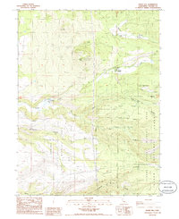
 1985 Shingletown1986 Print · USGSShingletown and the rugged upland between the forks of Battle Creek are captured here in the mid-1980s. Local researchers can trace power and water networks through the Inskip Powerhouse, Darrah Springs State Fish Hatchery, and family landmarks like Long Ranch.
 - 1985 Map of Manton, 1986 Print
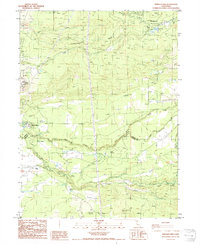
 1985 Manton1986 Print · USGSManton and the Shasta-Tehama county line are captured here in the mid-1980s, revealing a landscape shaped by hydroelectric power and timber. Genealogists and researchers can trace the local Cem, the Volta Powerhouse, and the fire lookout at Lookout Tower Digger Butte.
 - 1986 Map of Mineral
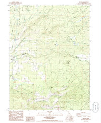
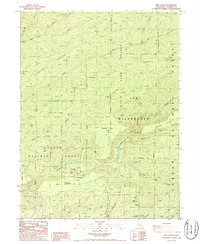
 1986 Mineral1986 Print · USGSThe high Sierra forests of Tehama County are captured here in the 1980s, centered on the Lassen Volcanic Nat Park Headquarters. Researchers can locate historic forest stations and unique landmarks like Mineral Meadows, the Hole in the Ground, and the small settlement of Mill Creek.2 unique versions available
 - 1986 Map of Ishi Caves
 1986 Ishi Caves1986 Print · USGSTehama County's high ridges and deep canyons were surveyed in the 1980s, revealing a landscape of remote cattle camps and indigenous history. Researchers can locate named sites like the Ishi Caves (Yahi Indian Camp), Apperson Cow Camp, and the crossing at Grapevine Crossing.4 unique versions available
 - 1986 Map of Panther Spring
 1986 Panther Spring1986 Print · USGSTehama County's high country is captured here during the 1980s, showcasing the transition from early ranching sites to protected wilderness. Researchers can trace the locations of Peligreen Place and Avery Place near Panther Spring.
 - 1987 Map of Willows, 1988 Print
 1987 Willows1988 Print · USGSThe northern Sacramento Valley meets the Coast Range in the late eighties, showing a landscape defined by water and transit. Researchers can trace the Southern Pacific railroad past Artois and Corning, or locate family-named landmarks like Larkins Childrens Rancho and Snaden Island.2 unique versions available
 - 1989 Map of Lake Almanor, 1990 Print
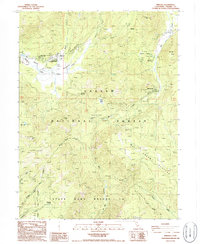
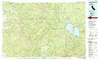 1989 Lake Almanor1990 Print · USGSUpper Plumas and Tehama counties appear here in the late eighties as a landscape of timber, volcanic peaks, and high-country reservoirs. Genealogists and historians can trace settlements from Chester and Westwood to mountain outposts like Mineral and Jonesville.2 unique versions available
End of results
Showing maps 1-24 of 24
Top cities of Tehama County
- Red Bluff historical maps
- Corning historical maps
- Los Molinos historical maps
- Rancho Tehama Reserve historical maps
- Tehama historical maps
- Vina historical maps
See more
Frequently asked questions
- What are the different types of historical maps available for Tehama County?
- What is the oldest map of Tehama County?
- Where can I purchase historical maps of Tehama County for my home or office?
- Where can I download high-res historical maps of Tehama County?
- Are there historical topographic maps available for Tehama County?
- Is there historical aerial imagery available for Tehama County?
- Where are historical maps of Tehama County sourced from?