1910s Maps of Tehama County, California
Explore 3 historic maps of Tehama County from the 1910s. These maps offer a rare glimpse into what life looked like during the 1910s — showing old roads, neighborhoods, homes, and landmarks that have changed or disappeared over time.
Whether you're researching your family's past, planning a metal detecting trip, or studying how Tehama County's landscape evolved across the 1910s, these high-resolution maps are a powerful tool for exploring the history of this region.
- Focus on a specific era: All maps on this page are from the 1910s, giving you a focused view of this time period.
- See what’s changed: Compare century-old streets, trails, and buildings to today's modern landscape using overlays and satellite layers.
- Research with precision: Use these maps for genealogy, historical research, land use analysis, or educational projects.
- View, download, or print: Maps are fully viewable online in high resolution, and can be downloaded or printed for your own records.
Start exploring Tehama County's history through authentic maps from the 1910s. This is your window into the past.
Tehama County, CA maps
(3)- 1912 Map of Singer Creek
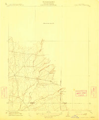 1912 Singer Creek1912 Print · USGSUpper Sacramento Valley ranching and school life are preserved in this early twentieth-century survey of the foothills. Researchers can trace the Tehama Co Butte Co line and find rural landmarks like the Liveoak School and Singer Creek.2 unique versions available
 - 1914 Map of Kirkwood
 1914 Kirkwood1914 Print · USGSThe northern Sacramento Valley's agricultural transition is on display here in the years before the Great War. Genealogists and researchers can trace early rail sidings and water networks like Kirkwood, Malton, and the Lemon Home Colony Canal.
 - 1914 Map of McIntosh Landing
 1914 McIntosh Landing1914 Print · USGSThe Sacramento River corridor north of Hamilton City is shown here in the early twentieth century as a complex landscape of shifting islands and landings. Trace the historic riverfront at McIntosh Landing or follow the path of the Central Irrigation Canal.
End of results
Showing maps 1-3 of 3
Top cities of Tehama County
- Red Bluff historical maps
- Corning historical maps
- Los Molinos historical maps
- Rancho Tehama Reserve historical maps
- Tehama historical maps
- Vina historical maps
See more
Frequently asked questions
- What are the different types of historical maps available for Tehama County?
- What is the oldest map of Tehama County?
- Where can I purchase historical maps of Tehama County for my home or office?
- Where can I download high-res historical maps of Tehama County?
- Are there historical topographic maps available for Tehama County?
- Is there historical aerial imagery available for Tehama County?
- Where are historical maps of Tehama County sourced from?