1900s (20th Century) Maps of Ventura County, California
Explore 197 historic maps of Ventura County from the 1900s (20th Century). These maps offer a rare glimpse into what life looked like during the 1900s — showing old roads, neighborhoods, homes, and landmarks that have changed or disappeared over time.
Whether you're researching your family's past, planning a metal detecting trip, or studying how Ventura County's landscape evolved across the 1900s, these high-resolution maps are a powerful tool for exploring the history of this region.
- Focus on a specific era: All maps on this page are from the 1900s, giving you a focused view of this time period.
- See what’s changed: Compare century-old streets, trails, and buildings to today's modern landscape using overlays and satellite layers.
- Research with precision: Use these maps for genealogy, historical research, land use analysis, or educational projects.
- View, download, or print: Maps are fully viewable online in high resolution, and can be downloaded or printed for your own records.
Start exploring Ventura County's history through authentic maps from the 1900s. This is your window into the past.
Ventura County, CA maps
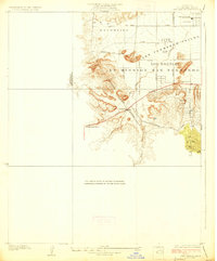
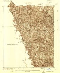
(197)- 1900 Map of Triunfo Pass
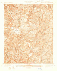
 1900 Triunfo Pass1900 Print · USGSIn the final year of the nineteenth century, the coast between Ventura and Los Angeles remained a series of massive ranchos and canyons. Genealogists and historians can trace early settlements like Newbury Park and Vejor, or follow the ancient Boundary Line across the Santa Monica Mountains.2 unique versions available
 - 1900 Map of Piru
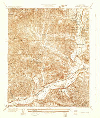
 1900 Piru1900 Print · USGSVentura County thrived along the rail-and-river corridor at the turn of the century as agriculture and ranching expanded. Trace the early layouts of Fillmore, Moorpark, and Piru or locate family landmarks in Bardsdale and Camulos.
 - 1903 Map of Santa Paula
 1903 Santa Paula1903 Print · USGSVentura County at the turn of the century shows a landscape of deep canyons and growing rail towns before the era of modern development. Genealogists can trace family names and homesteads near Santa Paula, Nordhoff, and the Ex Mission San Buenaventura grant lands.6 unique versions available
 - 1903 Map of Calabasas
 1903 Calabasas1903 Print · USGSThe northern reaches of the Santa Monica Mountains and the western San Fernando Valley are shown here at the turn of the century. Genealogists and historians can trace early ranch boundaries like Encino and Las Virgenes, or locate the original sites of Grape Arbor and the Chatsworth Park Branch railroad.8 unique versions available
 - 1903 Map of Mt. Pinos
 1903 Mt. Pinos1903 Print · USGSVentura and Kern counties at the start of the century remain largely a wild backcountry of forest reserves and high peaks. Genealogists and historians can trace early outposts like Pattiway, the high-altitude Frazier Borax Mine, and the Pine Mtn Lodge.7 unique versions available
 - 1903 Map of Tejon
 1903 Tejon1903 Print · USGSThe high passes and desert fringes of the Tehachapis come alive in this survey of the early twentieth-century frontier. Genealogists and historians can trace the foundations of Old Fort Tejon, follow the trail through Tejon Pass, or locate early mining sites like Frazier Mine.7 unique versions available
 - 1903 Map of Camulos
 1903 Camulos1903 Print · USGSSouthern California at the dawn of the twentieth century shows a landscape of ranchos and early rail towns. Trace the old routes through Simi and Camulos, or locate vanished stops like Ternez Siding and the coastal piers at Port Los Angeles.5 unique versions available
 - 1903 Map of Santa Susana
 1903 Santa Susana1903 Print · USGSNorthern Los Angeles and Ventura counties are captured here at the start of the twentieth century, as the railroad transformed the frontier. Trace early rail hubs at Newhall and Saugus, and find the engineering feats of the Santa Susana Tunnel and Fernando Tunnel.8 unique versions available
 - 1904 Map of Ventura
 1904 Ventura1904 Print · USGSThe coastal shelf and interior valleys of Ventura County appear here in the early twentieth century, showing a landscape of ranchos and new rail lines. Genealogists and historians can locate early settlements like Matilija and Oakview or trace the Southern Pacific RR along the Santa Barbara Channel.6 unique versions available
 - 1904 Map of Hueneme
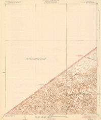
 1904 Hueneme1904 Print · USGSCoastal Ventura County is shown here in the early 1900s, when ranching and rail transport shaped the fertile Oxnard Plain. Genealogists and historians can trace the early footprints of Oxnard, the port at Hueneme, and rural stops like Leesdale along the Southern Pacific R. R.5 unique versions available
 - 1921 Map of Piru
 1921 Piru1921 Print · USGSThe Santa Clara River valley and southern Ventura County are shown here in the early twentieth century as the rail network expanded. Genealogists and historians can trace old property lines and rail stops at Sespe Sta, Camulos, and Bardsdale.4 unique versions available
 - 1921 Map of Triunfo Pass
 1921 Triunfo Pass1921 Print · USGSThe coastal canyons and mountain passes of Ventura and Los Angeles counties are captured here at the turn of the century. Genealogists and historians can trace early settlements at Newbury Park and Triunfo, or follow the rugged drainage of Dume Canyon to the sea.3 unique versions available
 - 1925 Map of Chatsworth
 1925 Chatsworth1925 Print · USGSThe western San Fernando Valley appears here in the mid-1920s as a landscape of new reservoirs and expanding rail lines. Genealogists and local historians can trace the early streets of Chatsworth, the grounds of Oakwood Cemetery, and the historic El Escorpion tract.
 - 1927 Map of Chatsworth
 1927 Chatsworth1927 Print · USGSIn the mid-1920s, the western San Fernando Valley was a landscape of emerging townsets and critical water infrastructure. Trace early street grids and rail lines near Chatsworth, Owensmouth, and the Chatsworth Reservoir.
 - 1928 Map of Dry Canyon
 1928 Dry Canyon1928 Print · USGSThe western edge of the San Fernando Valley appears here in the late twenties, balancing between historic ranch lands and early townsite development. Trace the early streets of Owensmouth and Girard, or locate the rural Calabasas School and the original path of Mulholland Highway.
 - 1929 Map of Chatsworth
 1929 Chatsworth1929 Print · USGSThe foothills of the Santa Susana Mountains come into focus in the late 1920s as Los Angeles began its westward expansion. Genealogists and historians can trace the early boundaries of Oakwood Cemetery, the Southern Pacific rail line, and the fledgling Twin Lakes Addition.
 - 1929 Map of Dry Canyon
 1929 Dry Canyon1929 Print · USGSLos Angeles County canyon country appears here in the late twenties, during a period of early mountain settlement and survey refinement. Researchers can locate family landmarks like Calabasas Highlands, the Calabasas Sch, and early trail hubs such as Brents Junction.
 - 1929 Map of Vejor
 1929 Vejor1929 Print · USGSThe western edges of Los Angeles County appear as a rural landscape of canyons and country clubs during the late twenties. Trace early mountain settlements like Cornell and Picture City, or find local landmarks such as Malibu Lake and the Las Virgenes Sch.
 - 1929 Map of Pico
 1929 Pico1929 Print · USGSThe northern Santa Susana Mountains were a hub of early petroleum activity in the late 1920s. Trace the historic footprint of the Pico Oil Field and follow early mountain routes through Pico Canyon and Towsley Canyon.
 - 1931 Map of Whitaker Peak
 1931 Whitaker Peak1931 Print · USGSThe northwestern mountains of Los Angeles County appear here in the early 1930s, showing a landscape defined by forest service outposts and deep canyons. Researchers can trace the original locations of Agua Blanca Camp, the Piru Ranger Station, and the city-run Oak Flat Playground.
 - 1931 Map of Santa Felicia Canyon
 1931 Santa Felicia Canyon1931 Print · USGSCanyon ranching and cattle camps define the Ventura-Los Angeles border during the early 1930s. Genealogists and researchers can trace the locations of the Dohany Cattle Camp, Martinez Ranch, and Leckler Ranch.
 - 1931 Map of Castaic
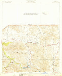
 1931 Castaic1931 Print · USGSCastaic and the Santa Clara River valley appear here in the early 1930s, caught between the era of ranching and the rise of the oil industry. Researchers can find family landmarks like Sloane Ranch and the Val Verde Lodge, or trace the old U S Highway No 99.
 - 1932 Map of Seminole
 1932 Seminole1932 Print · USGSThe Santa Monica Mountains and Las Virgenes interior are captured here in the early thirties, showing the rural foothills before modern development. Trace early canyon settlements and school sites like Malibu Junction, Picture City, and Cornell Sch.2 unique versions available
 - 1932 Map of Russell Valley
 1932 Russell Valley1932 Print · USGSThe western Santa Monica Mountains and the ranch lands of the early 1930s are captured here as the region began to modernize. Researchers can trace early transport routes like Decker Road and the original Ventura Highway through Russell Valley.2 unique versions available
 - 1932 Map of Beartrap Canyon
 1932 Beartrap Canyon1932 Print · USGSThe northern reaches of Los Angeles County appear in the early 1930s as a vital transit corridor through the mountains. Researchers can trace the path of U S Highway No 99 past the General Petroleum Company Liebre Pumping Sta and the lonely Halfway Inn.
Showing maps 1-25 of 197
Top cities of Ventura County
- Oxnard historical maps
- Thousand Oaks historical maps
- Simi Valley historical maps
- Ventura historical maps
- Camarillo historical maps
- Moorpark historical maps
See more
Frequently asked questions
- What are the different types of historical maps available for Ventura County?
- What is the oldest map of Ventura County?
- Where can I purchase historical maps of Ventura County for my home or office?
- Where can I download high-res historical maps of Ventura County?
- Are there historical topographic maps available for Ventura County?
- Is there historical aerial imagery available for Ventura County?
- Where are historical maps of Ventura County sourced from?