1920s Maps of Ventura County, California
Explore 9 historic maps of Ventura County from the 1920s. These maps offer a rare glimpse into what life looked like during the 1920s — showing old roads, neighborhoods, homes, and landmarks that have changed or disappeared over time.
Whether you're researching your family's past, planning a metal detecting trip, or studying how Ventura County's landscape evolved across the 1920s, these high-resolution maps are a powerful tool for exploring the history of this region.
- Focus on a specific era: All maps on this page are from the 1920s, giving you a focused view of this time period.
- See what’s changed: Compare century-old streets, trails, and buildings to today's modern landscape using overlays and satellite layers.
- Research with precision: Use these maps for genealogy, historical research, land use analysis, or educational projects.
- View, download, or print: Maps are fully viewable online in high resolution, and can be downloaded or printed for your own records.
Start exploring Ventura County's history through authentic maps from the 1920s. This is your window into the past.
Ventura County, CA maps
(9)- 1921 Map of Piru
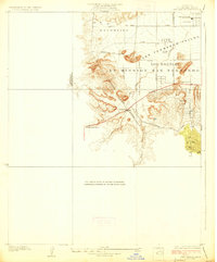
 1921 Piru1921 Print · USGSThe Santa Clara River valley and southern Ventura County are shown here in the early twentieth century as the rail network expanded. Genealogists and historians can trace old property lines and rail stops at Sespe Sta, Camulos, and Bardsdale.4 unique versions available
 - 1921 Map of Triunfo Pass
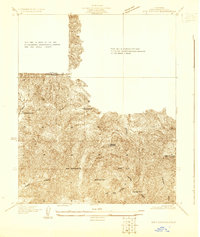
 1921 Triunfo Pass1921 Print · USGSThe coastal canyons and mountain passes of Ventura and Los Angeles counties are captured here at the turn of the century. Genealogists and historians can trace early settlements at Newbury Park and Triunfo, or follow the rugged drainage of Dume Canyon to the sea.3 unique versions available
 - 1925 Map of Chatsworth
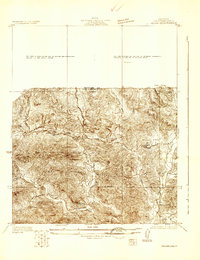
 1925 Chatsworth1925 Print · USGSThe western San Fernando Valley appears here in the mid-1920s as a landscape of new reservoirs and expanding rail lines. Genealogists and local historians can trace the early streets of Chatsworth, the grounds of Oakwood Cemetery, and the historic El Escorpion tract.
 - 1927 Map of Chatsworth
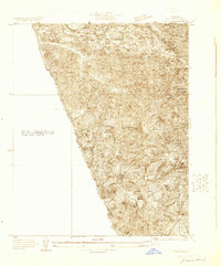
 1927 Chatsworth1927 Print · USGSIn the mid-1920s, the western San Fernando Valley was a landscape of emerging townsets and critical water infrastructure. Trace early street grids and rail lines near Chatsworth, Owensmouth, and the Chatsworth Reservoir.
 - 1928 Map of Dry Canyon
 1928 Dry Canyon1928 Print · USGSThe western edge of the San Fernando Valley appears here in the late twenties, balancing between historic ranch lands and early townsite development. Trace the early streets of Owensmouth and Girard, or locate the rural Calabasas School and the original path of Mulholland Highway.
 - 1929 Map of Chatsworth
 1929 Chatsworth1929 Print · USGSThe foothills of the Santa Susana Mountains come into focus in the late 1920s as Los Angeles began its westward expansion. Genealogists and historians can trace the early boundaries of Oakwood Cemetery, the Southern Pacific rail line, and the fledgling Twin Lakes Addition.
 - 1929 Map of Dry Canyon
 1929 Dry Canyon1929 Print · USGSLos Angeles County canyon country appears here in the late twenties, during a period of early mountain settlement and survey refinement. Researchers can locate family landmarks like Calabasas Highlands, the Calabasas Sch, and early trail hubs such as Brents Junction.
 - 1929 Map of Vejor
 1929 Vejor1929 Print · USGSThe western edges of Los Angeles County appear as a rural landscape of canyons and country clubs during the late twenties. Trace early mountain settlements like Cornell and Picture City, or find local landmarks such as Malibu Lake and the Las Virgenes Sch.
 - 1929 Map of Pico
 1929 Pico1929 Print · USGSThe northern Santa Susana Mountains were a hub of early petroleum activity in the late 1920s. Trace the historic footprint of the Pico Oil Field and follow early mountain routes through Pico Canyon and Towsley Canyon.
End of results
Showing maps 1-9 of 9
Top cities of Ventura County
- Oxnard historical maps
- Thousand Oaks historical maps
- Simi Valley historical maps
- Ventura historical maps
- Camarillo historical maps
- Moorpark historical maps
See more
Frequently asked questions
- What are the different types of historical maps available for Ventura County?
- What is the oldest map of Ventura County?
- Where can I purchase historical maps of Ventura County for my home or office?
- Where can I download high-res historical maps of Ventura County?
- Are there historical topographic maps available for Ventura County?
- Is there historical aerial imagery available for Ventura County?
- Where are historical maps of Ventura County sourced from?