1980s Maps of Ventura County, California
Explore 5 historic maps of Ventura County from the 1980s. These maps offer a rare glimpse into what life looked like during the 1980s — showing old roads, neighborhoods, homes, and landmarks that have changed or disappeared over time.
Whether you're researching your family's past, planning a metal detecting trip, or studying how Ventura County's landscape evolved across the 1980s, these high-resolution maps are a powerful tool for exploring the history of this region.
- Focus on a specific era: All maps on this page are from the 1980s, giving you a focused view of this time period.
- See what’s changed: Compare century-old streets, trails, and buildings to today's modern landscape using overlays and satellite layers.
- Research with precision: Use these maps for genealogy, historical research, land use analysis, or educational projects.
- View, download, or print: Maps are fully viewable online in high resolution, and can be downloaded or printed for your own records.
Start exploring Ventura County's history through authentic maps from the 1980s. This is your window into the past.
Ventura County, CA maps
(5)- 1981 Map of Cuyama
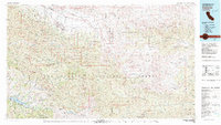 1981 Cuyama1981 Print · USGSThe high Cuyama Valley and the vast reaches of the Los Padres National Forest are captured here in the early eighties. Researchers can trace the San Andreas Rift Zone past New Cuyama or locate remote outposts like the Gibraltar Mine and Thorn Lookout.2 unique versions available
 - 1981 Map of Long Beach
 1981 Long Beach1981 Print · USGSCoastal Los Angeles and the South Bay reached a peak of industrial and suburban maturity in the early eighties. Researchers can trace the development of aerospace and maritime hubs through landmarks like the Queen Mary, Fort MacArthur, and Signal Hill.3 unique versions available
 - 1981 Map of Lancaster, 1984 Print
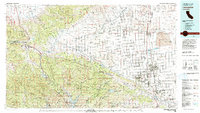 1981 Lancaster1984 Print · USGSThe high desert and mountain passes of northern Los Angeles County come alive in this early eighties survey. Researchers can trace the San Andreas Rift Zone past remote outposts like Gorman or locate the historic Golden Queen Mine near the Mojave edge.2 unique versions available
 - 1982 Map of Santa Barbara, 1983 Print
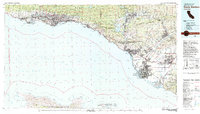 1982 Santa Barbara1983 Print · USGSCoastal California in the early eighties exhibits a landscape of growing cities and massive military and academic footprints. Genealogists and historians can trace the Southern Pacific rail line through Santa Barbara or explore the boundaries of historic ranchos like Las Positas y Calera.3 unique versions available
 - 1984 Map of Laguna Harbor
 1984 Laguna Harbor1984 Print · USGSThe Channel Islands off the coast of Southern California are documented in the mid-eighties as they appeared within Channel Islands National Park. Researchers can trace the rugged shoreline and find specific maritime locations like Laguna Harbor, Skunk Point, and the Landing Field on Santa Cruz Island.
End of results
Showing maps 1-5 of 5
Top cities of Ventura County
- Oxnard historical maps
- Thousand Oaks historical maps
- Simi Valley historical maps
- Ventura historical maps
- Camarillo historical maps
- Moorpark historical maps
See more
Frequently asked questions
- What are the different types of historical maps available for Ventura County?
- What is the oldest map of Ventura County?
- Where can I purchase historical maps of Ventura County for my home or office?
- Where can I download high-res historical maps of Ventura County?
- Are there historical topographic maps available for Ventura County?
- Is there historical aerial imagery available for Ventura County?
- Where are historical maps of Ventura County sourced from?