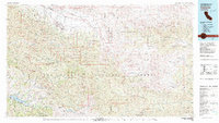
1981 Map of Cuyama
USGS Topo · Published 1981About this map
The Cuyama Valley forms a high-desert corridor between the massive ranges of the Los Padres National Forest in this 1981 survey. Settlements like New Cuyama and Ventucopa follow the drainage of the Cuyama River, while further south the San Rafael Mountains and the San Emigdio Mountains dominate the landscape. This era of mapping emphasizes conservation and specific land use, shown through the boundaries of the Sisquoc Condor Sanctuary and the Sespe Condor Sanctuary.
Find a feature on this map
69 named features on this map. Tap any name to fly to it.
Don’t see what you’re looking for? This feature index may not catch every label — zoom into the map to look around manually.
Map Details
Editions of this 1981 Cuyama Map
2 editions found
Other maps of this area

1900 · Piru
USGS Topo · 1:62,500

1902 · Santa Ynez
USGS Topo · 1:125,000

1903 · Santa Paula
USGS Topo · 1:62,500

1903 · Mt. Pinos
USGS Topo · 1:125,000

1903 · Tejon
USGS Topo · 1:125,000

1903 · Camulos
USGS Topo · 1:125,000

1904 · Ventura
USGS Topo · 1:62,500

1905 · Santa Ynez
USGS Topo · 1:125,000

1905 · Lompoc
USGS Topo · 1:125,000

1910 · Buena Vista Lake
USGS Topo · 1:125,000