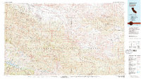
1981 Map of Cuyama
USGS Topo · Published 1981About this map
The Cuyama Valley serves as the central corridor for this 1980s-era topographic study, where agricultural development and remote settlements like New Cuyama and Ventucopa line the course of the Cuyama River. This landscape is dramatically defined by the tectonic activity of the San Andreas Rift Zone, which cuts through the San Emidgio Mountains to the northeast. To the south and west, the map details the transition into the Los Padres National Forest, showing the protected habitats of the Sisquoc Condor Sanctuary and the Sespe Condor Sanctuary. The complex terrain of the San Rafael Mountains and Sierra Madre Mountains creates a backdrop for recreational landmarks such as the Cachuma County Recreation Area at Lake Cachuma. This record documents the region after the mid-century establishment of New Cuyama, capturing the balance between wilderness preservation and the high-desert community's reliance on the valley's transit routes.
Find a feature on this map
35 named features on this map. Tap any name to fly to it.
Don’t see what you’re looking for? This feature index may not catch every label — zoom into the map to look around manually.
Map Details
Editions of this 1981 Cuyama Map
2 editions found
Other maps of this area

1900 · Piru
USGS Topo · 1:62,500

1902 · Santa Ynez
USGS Topo · 1:125,000

1903 · Santa Paula
USGS Topo · 1:62,500

1903 · Mt. Pinos
USGS Topo · 1:125,000

1903 · Tejon
USGS Topo · 1:125,000

1903 · Camulos
USGS Topo · 1:125,000

1904 · Ventura
USGS Topo · 1:62,500

1905 · Santa Ynez
USGS Topo · 1:125,000

1905 · Lompoc
USGS Topo · 1:125,000

1910 · Buena Vista Lake
USGS Topo · 1:125,000