1950s Maps of Yolo County, California
Explore 45 historic maps of Yolo County from the 1950s. These maps offer a rare glimpse into what life looked like during the 1950s — showing old roads, neighborhoods, homes, and landmarks that have changed or disappeared over time.
Whether you're researching your family's past, planning a metal detecting trip, or studying how Yolo County's landscape evolved across the 1950s, these high-resolution maps are a powerful tool for exploring the history of this region.
- Focus on a specific era: All maps on this page are from the 1950s, giving you a focused view of this time period.
- See what’s changed: Compare century-old streets, trails, and buildings to today's modern landscape using overlays and satellite layers.
- Research with precision: Use these maps for genealogy, historical research, land use analysis, or educational projects.
- View, download, or print: Maps are fully viewable online in high resolution, and can be downloaded or printed for your own records.
Start exploring Yolo County's history through authentic maps from the 1950s. This is your window into the past.
Yolo County, CA maps
(45)- 1950 Map of Taylor Monument, 1960 Print
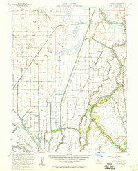
 1950 Taylor Monument1960 Print · USGSThe Sacramento River delta and American Basin are shown here in the mid-century, defined by an intricate system of levees and canals. You can trace the Sacramento Northern rail line and locate rural landmarks like American Basin School and Kiesel.
 - 1951 Map of Taylor Monument
 1951 Taylor Monument1951 Print · USGSThe Sacramento River delta and American Basin are shown at mid-century during a period of significant agricultural and infrastructure development. Trace local family history at Monument Sch, follow the Sacramento Northern rail, or locate the site of Radio Sta KCRA.
 - 1951 Map of Mt. Vaca, 1952 Print
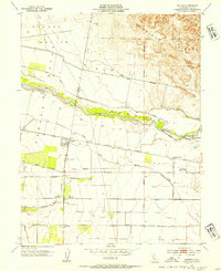
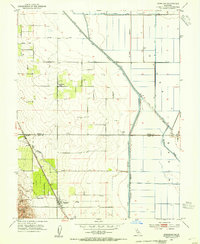
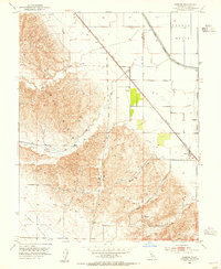
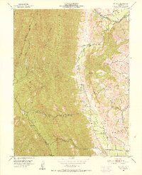 1951 Mt. Vaca1952 Print · USGSSolano County rangelands and the steep ridges of the Vaca Mountains appear here as they were in the early fifties. Local historians and genealogists can trace family holdings like Pioneer Ranch or find the former site of the Rhine School (Abandoned) along Alamo Creek.3 unique versions available
 - 1951 Map of Mt. Vaca, 1959 Print
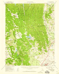 1951 Mt. Vaca1959 Print · USGSNorthern California's agricultural valleys and ridges are captured here in the early fifties. Researchers can trace rural life through landmarks like Peña House, Mankas Corner, and schools such as Gordon Valley School.2 unique versions available
 - 1952 Map of Verona, 1953 Print
 1952 Verona1953 Print · USGSThe confluence of the Sacramento and Feather Rivers in the early 1950s reveals a landscape shaped by levees, canals, and river landings. Genealogists and researchers can trace rural life at Pleasant Grove Sch or locate the historic river hubs at Verona and Vernon Landing.3 unique versions available
 - 1952 Map of Kirkville, 1953 Print
 1952 Kirkville1953 Print · USGSThe Sacramento River corridor in the early fifties is mapped here in detail, showing a landscape defined by industrial pumping and river landings. Genealogists and historians can trace family-named sites like Poffenbergers Landing, Tyndall Mound, and the settlement of Cranmore.3 unique versions available
 - 1952 Map of Woodland, 1953 Print
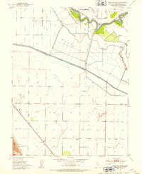
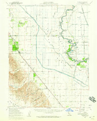
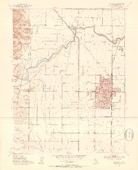 1952 Woodland1953 Print · USGSWoodland and the surrounding Yolo County landscape are captured here in the early fifties, featuring an extensive network of irrigation canals and rail. Genealogists can locate family sites near Willow Oak School, the Woodland Cemetery, and Plainfield Union Sch.7 unique versions available
 - 1952 Map of Merritt, 1953 Print
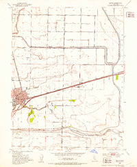
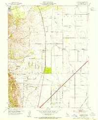
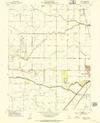 1952 Merritt1953 Print · USGSThe Yolo County plains come alive in the early 1950s, showing the early campus of the University of California College of Agriculture. Researchers can trace the legacy of the Southern Pacific through Merritt or locate mid-century landmarks like the Drive-in Theatre.6 unique versions available
 - 1952 Map of Saxon, 1953 Print
 1952 Saxon1953 Print · USGSSolano and Yolo counties are captured here in the early fifties, showing a landscape of established ranching and strategic water management. Genealogists and local historians can trace family-named lands like Bulkley Ranch and find the historic Tremont Cem near the Sacramento Northern line.5 unique versions available
 - 1952 Map of Liberty Island, 1953 Print
 1952 Liberty Island1953 Print · USGSThe California Delta's reclaimed marshlands are shown here in the early fifties, just as the region's hydraulic systems and gas exploration were maturing. Researchers can trace the levee-protected agricultural tracts of Liberty Island and find local landmarks like Liberty Farms and the Swing Bridge.3 unique versions available
 - 1952 Map of Eldorado Bend, 1953 Print
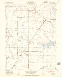
 1952 Eldorado Bend1953 Print · USGSThe Sacramento River winds through the fertile Central Valley in the early fifties, revealing an engineered landscape of levees and canals. Genealogists and local historians can trace the Southern Pacific rail line to Dufour or locate Marys Cemetery near the center of the basin.4 unique versions available
 - 1952 Map of Davis, 1953 Print
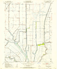
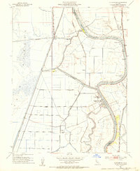
 1952 Davis1953 Print · USGSDavis and the University of California campus are centered in this mid-century survey of the Yolo County agricultural corridor. Researchers can trace the early footprint of the College of Agriculture, the Southern Pacific rail line, and the rural site of Swingle.8 unique versions available
 - 1952 Map of Courtland, 1953 Print
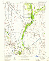
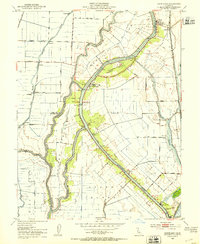 1952 Courtland1953 Print · USGSThe Sacramento Delta in the early fifties shows a landscape of engineered waterways and island farming communities. Genealogists and historians can trace the development of riverfront towns like Courtland and Locke or follow the Southern Pacific rail line.6 unique versions available
 - 1952 Map of Clarksburg, 1954 Print
 1952 Clarksburg1954 Print · USGSThe Sacramento River delta comes alive in the early 1950s, showing the intersection of heavy industry and ancient landmarks. Trace the agricultural roots of the region through the Sugar Beet Plant, find the Indian Mound, or locate the vanished stops of the Southern Pacific railroad.2 unique versions available
 - 1952 Map of Courtland, 1959 Print
 1952 Courtland1959 Print · USGSThe Sacramento Delta comes alive in the early fifties, showing a landscape defined by river commerce and sprawling ranch holdings. Family researchers can locate Tremont Cem, Liberty Sch, and long-established properties like Glide Ranch and Maxwell Ranch.3 unique versions available
 - 1952 Map of Knights Landing, 1959 Print
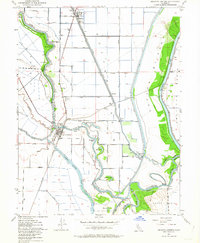
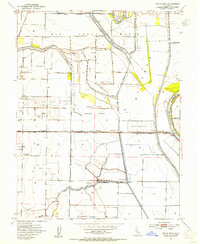
 1952 Knights Landing1959 Print · USGSMid-century Sutter and Yolo counties are defined here by a complex network of levees, bypasses, and river bends. Genealogists and local historians can trace family-named sites like Fairview Cemetery and Wilson School alongside the bustling rail lines of the Southern Pacific.2 unique versions available
 - 1952 Map of Knights Landing, 1964 Print
 1952 Knights Landing1964 Print · USGSThe riverfront and rail junction of Knights Landing are captured here in the early fifties, showing the intricate water management of the Sacramento Valley. Genealogists and historians can trace family-named landmarks like McGriff Lakes, the Knights Landing School, and the local cemetery.5 unique versions available
 - 1953 Map of Madison, 1954 Print
 1953 Madison1954 Print · USGSMadison and the surrounding Yolo County farmland are captured here in the early fifties during a period of steady agricultural growth. Researchers can trace the Southern Pacific line to the old Cottonwood Cemetery or locate local landmarks like Citrona and Jacobs Corner.4 unique versions available
 - 1953 Map of Dunnigan, 1954 Print
 1953 Dunnigan1954 Print · USGSThe agricultural heart of Yolo and Colusa counties is captured here in the early fifties, where the railroad meets the valley floor. Genealogists and historians can locate the Johns District School, the Johns Cem, and the rail stops at Dunnigan and Hershey.4 unique versions available
 - 1953 Map of Winters, 1954 Print
 1953 Winters1954 Print · USGSThe Yolo-Solano border comes alive in this mid-century survey of the agricultural valley floor and rising foothills. Local historians can trace the Southern Pacific rail line through Arroz or locate rural landmarks like Buckeye School and Putah Creek.6 unique versions available
 - 1953 Map of Grays Bend, 1954 Print
 1953 Grays Bend1954 Print · USGSThe Yolo County floodplains in the early fifties reveal a landscape defined by massive water projects and the Sacramento river-and-rail economy. Researchers can trace the path of the Elkhorn Ferry, the Willow Spring Union School, and the industrial Beet Pulp Silo.4 unique versions available
 - 1953 Map of Allendale, 1954 Print
 1953 Allendale1954 Print · USGSSolano County agriculture and rail infrastructure are on full display in the early fifties, centered on the Allendale community. Genealogists can locate family-named landmarks and rural institutions like Browns Valley School, Union Chapel, and the village of Hartley.6 unique versions available
 - 1953 Map of Zamora, 1955 Print
 1953 Zamora1955 Print · USGSYolo County's agricultural and energy landscape is captured here in the mid-fifties, centered on the Zamora rail stop and the eastern Dunnigan Hills. Genealogists and historians can trace early infrastructure like the Dunnigan Gas Field, several Gas Wells, and the Southern Pacific tracks.3 unique versions available
 - 1953 Map of Vacaville, 1959 Print
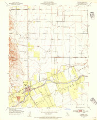
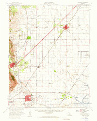 1953 Vacaville1959 Print · USGSSolano County's agricultural heartland is documented here during the mid-fifties as the local rail and military presence expanded. Genealogists and historians can trace numerous rural school sites like Grant Sch and lost rail stops such as Batavia or Dozier.
 - 1953 Map of Dunnigan, 1959 Print
 1953 Dunnigan1959 Print · USGSThe Sacramento River valley in the early 1950s shows a landscape of river landings and railroad towns at the height of its mid-century agricultural reach. Genealogists and historians can trace the foundations of Dunnigan and Zamora, or locate family landmarks like Johns Cemetery and Marys Cemetery.2 unique versions available
Showing maps 1-25 of 45
Top cities of Yolo County
- Davis historical maps
- Woodland historical maps
- West Sacramento historical maps
- Winters historical maps
- Esparto historical maps
- El Macero historical maps
Frequently asked questions
- What are the different types of historical maps available for Yolo County?
- What is the oldest map of Yolo County?
- Where can I purchase historical maps of Yolo County for my home or office?
- Where can I download high-res historical maps of Yolo County?
- Are there historical topographic maps available for Yolo County?
- Is there historical aerial imagery available for Yolo County?
- Where are historical maps of Yolo County sourced from?