1900-1909 Maps of Yolo County, California
Explore 8 historic maps of Yolo County from 1900-1909. These maps offer a rare glimpse into what life looked like during the 1900s — showing old roads, neighborhoods, homes, and landmarks that have changed or disappeared over time.
Whether you're researching your family's past, planning a metal detecting trip, or studying how Yolo County's landscape evolved across the 1900s, these high-resolution maps are a powerful tool for exploring the history of this region.
- Focus on a specific era: All maps on this page are from the 1900s, giving you a focused view of this time period.
- See what’s changed: Compare century-old streets, trails, and buildings to today's modern landscape using overlays and satellite layers.
- Research with precision: Use these maps for genealogy, historical research, land use analysis, or educational projects.
- View, download, or print: Maps are fully viewable online in high resolution, and can be downloaded or printed for your own records.
Start exploring Yolo County's history through authentic maps from the 1900s. This is your window into the past.
Yolo County, CA maps
(8)- 1902 Map of Napa
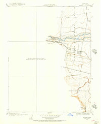
 1902 Napa1902 Print · USGSThe Napa Valley and Carquinez Strait are captured at the turn of the century, showing a landscape defined by maritime military posts and early vineyards. Genealogists and historians can trace the Mare Island Navy Yard, the Insane Asylum, and rail stops at Zinfandel and Rutherford.6 unique versions available
 - 1905 Map of Harrington, 1956 Print
 1905 Harrington1956 Print · USGSThe Sacramento Valley at the start of the twentieth century was a landscape of rail-dependent agriculture and seasonal creeks. Genealogists and historians can trace the early layout of Harrington and the path of the Southern Pacific Railroad as it crosses from Colusa into Yolo County.
 - 1905 Map of Esparto, 1957 Print
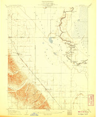
 1905 Esparto1957 Print · USGSWestern Yolo County at the turn of the century shows a landscape being transformed by irrigation and rail. Trace the early layout of Esparto and Capay along the Southern Pacific line and the extensive network of the Adams Canal.
 - 1907 Map of Dunnigan
 1907 Dunnigan1907 Print · USGSThe Sacramento Valley in the early 1900s is defined by its busy river landings and the emerging rail corridor. Genealogists can trace family footprints at Zamora Blacks Station P O or follow the river to Cranmore Landing and Derby Camp.3 unique versions available
 - 1907 Map of Woodland
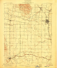 1907 Woodland1907 Print · USGSYolo County at the turn of the century reveals a landscape defined by early irrigation and the expansion of the Southern Pacific Railroad. Genealogists can trace family locations near Woodland, Madison, and the rural Union School.2 unique versions available
 - 1907 Map of Davisville
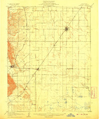
 1907 Davisville1907 Print · USGSYolo and Sacramento counties are captured here at a pivot point for river transit and rail growth. Researchers can trace early rural life via the Lisbon School, Taylor Monument Datey's Ferry, and the original footprint of Davisville.2 unique versions available
 - 1908 Map of Vacaville
 1908 Vacaville1908 Print · USGSNorthern California's agricultural heartland is captured here at the start of the century, centered on the rail corridors of the Southern Pacific. Genealogists can trace early homesteads and rail stops like Elmira, Maine Prairie, and the Cement Mill.3 unique versions available
 - 1908 Map of Courtland
 1908 Courtland1908 Print · USGSThe Sacramento Delta at the dawn of the twentieth century was a landscape of fertile river islands and vital waterborne transit. Genealogists and historians can trace the early footprints of Courtland, Clarksburg, and Freeport, or locate landmarks like the Free County Ferry and Indian Mound.3 unique versions available
End of results
Showing maps 1-8 of 8
Top cities of Yolo County
- Davis historical maps
- Woodland historical maps
- West Sacramento historical maps
- Winters historical maps
- Esparto historical maps
- El Macero historical maps
Frequently asked questions
- What are the different types of historical maps available for Yolo County?
- What is the oldest map of Yolo County?
- Where can I purchase historical maps of Yolo County for my home or office?
- Where can I download high-res historical maps of Yolo County?
- Are there historical topographic maps available for Yolo County?
- Is there historical aerial imagery available for Yolo County?
- Where are historical maps of Yolo County sourced from?