1940s Maps of Yolo County, California
Explore 15 historic maps of Yolo County from the 1940s. These maps offer a rare glimpse into what life looked like during the 1940s — showing old roads, neighborhoods, homes, and landmarks that have changed or disappeared over time.
Whether you're researching your family's past, planning a metal detecting trip, or studying how Yolo County's landscape evolved across the 1940s, these high-resolution maps are a powerful tool for exploring the history of this region.
- Focus on a specific era: All maps on this page are from the 1940s, giving you a focused view of this time period.
- See what’s changed: Compare century-old streets, trails, and buildings to today's modern landscape using overlays and satellite layers.
- Research with precision: Use these maps for genealogy, historical research, land use analysis, or educational projects.
- View, download, or print: Maps are fully viewable online in high resolution, and can be downloaded or printed for your own records.
Start exploring Yolo County's history through authentic maps from the 1940s. This is your window into the past.
Yolo County, CA maps
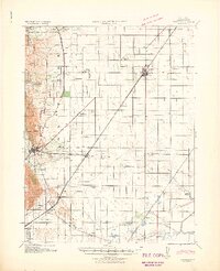
(15)- 1941 Map of Dunnigan
 1941 Dunnigan1941 Print · USGSYolo and Sutter counties are captured here in the early 1940s, showing a landscape defined by the shifting Sacramento River and the Southern Pacific rail line. Trace the history of river commerce at Rough and Ready Landing or locate family roots in Zamora Blacks Station P O and Dunnigan.
 - 1941 Map of Vacaville
 1941 Vacaville1941 Print · USGSSolano County’s fertile ranching and orchard lands are documented in the early 1940s, just before significant regional growth. Local historians can trace family-named school districts like Tremont District School and rural rail stops including Batavia and Cannon.
 - 1941 Map of Woodland
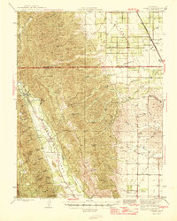
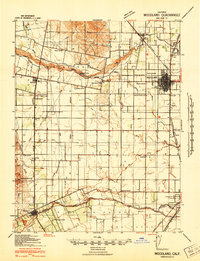 1941 Woodland1941 Print · USGSYolo County is captured here at the height of its pre-war agricultural expansion, dominated by an intricate network of irrigation canals and rail lines. Researchers can trace rural schoolhouse locations like Clover School and Gordon School or identify early landmarks such as the Yolo Fliers Club and the Airplane Beacon.
 - 1942 Map of Mt. Vaca
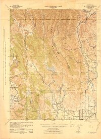 1942 Mt. Vaca1942 Print · USGSThe Vaca Mountains and eastern Napa County are captured during the early 1940s, showing a landscape of deep canyons and rising valley towns. Researchers can trace the rail corridors of the Southern Pacific near Fairfield or locate early water works like the Gordon Valley Dam.2 unique versions available
 - 1943 Map of Morgan Valley
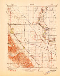
 1943 Morgan Valley1943 Print · USGSNorthern California ranching and mining country are captured in the early 1940s at the junction of Lake, Napa, and Yolo counties. Researchers can locate the Morgan Valley Sch and several mines like the Harrison Mine and Red Elephant Mine.
 - 1943 Map of Capay, 1945 Print
 1943 Capay1945 Print · USGSYolo and Napa counties are captured here in the mid-1940s, documenting the valley floor and ridge-lines before the creation of Lake Berryessa. Researchers can trace family ranch lands and lost school sites like Monticello, Oak Grove Sch, and Gunn Ranch.
 - 1944 Map of Morgan Valley
 1944 Morgan Valley1944 Print · USGSUpper California ranching and mercury mining country are shown here in the mid-1940s near the corner of Lake, Colusa, and Napa counties. Researchers can trace historic operations like Reid Mine, the old Morgan Valley Sch, and local hubs like Knoxville.2 unique versions available
 - 1945 Map of Capay
 1945 Capay1945 Print · USGSThe Berryessa and Capay valleys appear here in the final years before the creation of Lake Berryessa, documenting a lost agricultural landscape. Genealogists can trace family ranch holdings like Scott Ranch and Corbin Ranch alongside rural landmarks like Monticello and Apricot Sch.
 - 1945 Map of Rumsey
 1945 Rumsey1945 Print · USGSThe Capay Valley and northern Sacramento Valley meet here in the mid-1940s, showing a landscape of secluded canyons and rail-side settlements. Genealogists can trace family footprints near Rumsey, Guinda, and rural schoolhouses like Wildwood Sch.2 unique versions available
 - 1947 Map of Santa Rosa
 1947 Santa Rosa1947 Print · USGSNorthern California in the late 1940s was a landscape of agricultural valleys and vital rail hubs. Trace the historic routes of the Northwestern Pacific through Healdsburg or explore the mid-century waterfronts of Vallejo and Benicia near Mare Island.
 - 1947 Map of Sacramento, 1948 Print
 1947 Sacramento1948 Print · USGSThe Sacramento Valley meets the high Sierra during a period of post-war expansion. Trace the historic river delta islands like Grand Island or locate early airfield footprints at McClellan Air Force Base and Mather Air Force Base.2 unique versions available
 - 1948 Map of Sacramento, 1951 Print
 1948 Sacramento1951 Print · USGSPost-war Northern California comes alive in this regional survey, capturing the era of expansion between the Central Valley and the High Sierra. Researchers can trace the rail networks of the Central California Traction and Sacramento Northern RR or locate landmarks like the State Capitol and University of California Davis.
 - 1948 Map of Sacramento West, 1958 Print
 1948 Sacramento West1958 Print · USGSYolo County and the western edge of the state capital are seen here in the late forties during a period of rapid post-war growth. Genealogists and historians can trace neighborhood development in Bryte and Broderick or locate landmarks like Peethill and the Yolo Causeway.
 - 1949 Map of Sacramento West
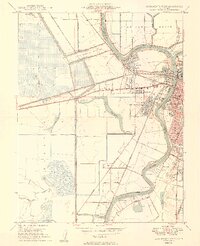 1949 Sacramento West1949 Print · USGSWest Sacramento and the neighboring river communities are documented here just after the war, showing the vital levee systems and rail lines of Yolo County. Genealogists and historians can trace Bryte, Broderick, and early neighborhood sites like Westacre Sch.2 unique versions available
 - 1949 Map of Santa Rosa
 1949 Santa Rosa1949 Print · USGSThe North Bay and Wine Country appear here in the late 1940s, when the Northwestern Pacific RR still dominated regional transit. Genealogists and historians can trace old coastal outposts like Anchor Bay Settlement and the early layout of Santa Rosa.2 unique versions available
End of results
Showing maps 1-15 of 15
Top cities of Yolo County
- Davis historical maps
- Woodland historical maps
- West Sacramento historical maps
- Winters historical maps
- Esparto historical maps
- El Macero historical maps
Frequently asked questions
- What are the different types of historical maps available for Yolo County?
- What is the oldest map of Yolo County?
- Where can I purchase historical maps of Yolo County for my home or office?
- Where can I download high-res historical maps of Yolo County?
- Are there historical topographic maps available for Yolo County?
- Is there historical aerial imagery available for Yolo County?
- Where are historical maps of Yolo County sourced from?