1960s Maps of Yolo County, California
Explore 6 historic maps of Yolo County from the 1960s. These maps offer a rare glimpse into what life looked like during the 1960s — showing old roads, neighborhoods, homes, and landmarks that have changed or disappeared over time.
Whether you're researching your family's past, planning a metal detecting trip, or studying how Yolo County's landscape evolved across the 1960s, these high-resolution maps are a powerful tool for exploring the history of this region.
- Focus on a specific era: All maps on this page are from the 1960s, giving you a focused view of this time period.
- See what’s changed: Compare century-old streets, trails, and buildings to today's modern landscape using overlays and satellite layers.
- Research with precision: Use these maps for genealogy, historical research, land use analysis, or educational projects.
- View, download, or print: Maps are fully viewable online in high resolution, and can be downloaded or printed for your own records.
Start exploring Yolo County's history through authentic maps from the 1960s. This is your window into the past.
Yolo County, CA maps
(6)- 1962 Map of Santa Rosa
 1962 Santa Rosa1962 Print · USGSThe North Bay and Wine Country were entering a period of significant growth in the early sixties, anchored by established rail corridors and coastal maritime commerce. Genealogists and historians can trace the development of Santa Rosa, locate the Mare Island Naval Shipyard, and follow the Northwestern Pacific RR through the Cotati Valley.
 - 1964 Map of Santa Rosa
 1964 Santa Rosa1964 Print · USGSThe North Bay and Wine Country appear in the mid-fifties during a period of significant military and educational growth. Trace old rail lines like the Northwestern Pacific RR and explore historic sites from Petaluma to the Benicia Arsenal.
 - 1967 Map of Sacramento West, 1968 Print
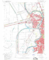 1967 Sacramento West1968 Print · USGSGreater Sacramento and its industrial waterfront come alive in this mid-century survey of the river and rail networks. Genealogists and historians can trace the growth of West Sacramento neighborhoods, the Port of Sacramento facilities, and schools like Holy Cross Sch.3 unique versions available
 - 1967 Map of Verona, 1968 Print
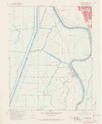
 1967 Verona1968 Print · USGSIn the late 1960s, the Sacramento and Feather rivers met amidst a complex landscape of irrigation and agriculture. Researchers can trace rural community life at Verona, locate family history at Pleasant Grove Cem, and follow the Old Railroad Grade through the basin.2 unique versions available
 - 1967 Map of Taylor Monument, 1968 Print
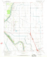 1967 Taylor Monument1968 Print · USGSThe Sacramento valley was undergoing rapid change in the late 1960s as suburban infrastructure met traditional agriculture. You can trace the path of the Sacramento Northern railway and locate family landmarks like the Natomas Sch and Fishermans Lake.4 unique versions available
 - 1967 Map of Clarksburg, 1969 Print
 1967 Clarksburg1969 Print · USGSThe Sacramento Delta comes to life in the late sixties as a busy landscape of river commerce and rail transport. Genealogists and historians can trace the foundations of Clarksburg, locate the Pony Express Sch, and explore the reach of the Sacramento Northern railroad.5 unique versions available
End of results
Showing maps 1-6 of 6
Top cities of Yolo County
- Davis historical maps
- Woodland historical maps
- West Sacramento historical maps
- Winters historical maps
- Esparto historical maps
- El Macero historical maps
Frequently asked questions
- What are the different types of historical maps available for Yolo County?
- What is the oldest map of Yolo County?
- Where can I purchase historical maps of Yolo County for my home or office?
- Where can I download high-res historical maps of Yolo County?
- Are there historical topographic maps available for Yolo County?
- Is there historical aerial imagery available for Yolo County?
- Where are historical maps of Yolo County sourced from?