1990s Maps of Yolo County, California
Explore 9 historic maps of Yolo County from the 1990s. These maps offer a rare glimpse into what life looked like during the 1990s — showing old roads, neighborhoods, homes, and landmarks that have changed or disappeared over time.
Whether you're researching your family's past, planning a metal detecting trip, or studying how Yolo County's landscape evolved across the 1990s, these high-resolution maps are a powerful tool for exploring the history of this region.
- Focus on a specific era: All maps on this page are from the 1990s, giving you a focused view of this time period.
- See what’s changed: Compare century-old streets, trails, and buildings to today's modern landscape using overlays and satellite layers.
- Research with precision: Use these maps for genealogy, historical research, land use analysis, or educational projects.
- View, download, or print: Maps are fully viewable online in high resolution, and can be downloaded or printed for your own records.
Start exploring Yolo County's history through authentic maps from the 1990s. This is your window into the past.
Yolo County, CA maps
(9)- 1992 Map of Merritt, 1997 Print
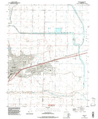
 1992 Merritt1997 Print · USGSYolo County is captured here in the early nineties as the university town and its agricultural surroundings expand. Researchers can trace the development of Plainfield, the irrigation routes of Willow Slough, and the boundaries of the University of California.
 - 1992 Map of Davis, 1997 Print
 1992 Davis1997 Print · USGSDavis and its university campus are captured in the early 1990s as the town expanded into the surrounding Sacramento Valley farmlands. Researchers can trace local landmarks like Davis Cemetery or old railroad stops at Swingle and Webster.
 - 1992 Map of Sacramento West, 1997 Print
 1992 Sacramento West1997 Print · USGSSacramento and its western neighbor are seen here in the early 1990s as the riverfront continued to transition from industry to preservation. Researchers can trace the massive Deep Water Ship Channel and find local landmarks like Old Sacramento State Historical Park and William Land Park.
 - 1992 Map of Madison, 1997 Print
 1992 Madison1997 Print · USGSYolo County's agricultural landscape is captured here in the early nineties as it balances historic land grants with modern irrigation. Researchers can trace the legacy of local families through the Cottonwood Cemetery or locate the small rural outposts of Madison and Citrona.
 - 1992 Map of Zamora, 1997 Print
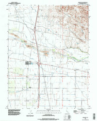
 1992 Zamora1997 Print · USGSYolo County at the start of the nineties reveals a landscape of energy extraction and sophisticated water management. Genealogists and local historians can trace the development of Zamora, the Dunnigan Hills Gas Field, and the rail siding at Goodnow.2 unique versions available
 - 1993 Map of Lodi, 1994 Print
 1993 Lodi1994 Print · USGSNorthern California's delta country and the growing Central Valley corridors are captured here in the early nineties. Genealogists and historians can trace the intricate island tracts, old railroad lines like the Sacramento Northern RR, and established local landmarks including the Lodi Memorial Cemetery and University of the Pacific.2 unique versions available
 - 1994 Map of Sacramento
 1994 Sacramento1994 Print · USGSThe Sacramento valley was a landscape of massive flood control and military aviation during the mid-nineties. Researchers can trace the complex network of the Yolo Bypass and the Sacramento River alongside McClellan Air Force Base and Zamora.2 unique versions available
 - 1998 Map of Wilson Valley, 2002 Print
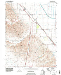
 1998 Wilson Valley2002 Print · USGSLake and Colusa counties appear here in the late twentieth century as a landscape of deep canyons and seasonal water. Researchers can trace the winding course of Cache Creek and locate remote landmarks like Dunfield Spring or the high point of Grizzly Peak.
 - 1998 Map of Lake Berryessa, 2002 Print
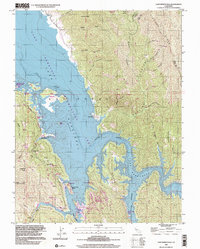 1998 Lake Berryessa2002 Print · USGSThe Napa County reservoir landscape appears in the late nineties, documenting the established resort communities along the shoreline. Trace local landmarks and public access points like Spanish Flat, the Monticello Cem, and Steele Park Resort.
End of results
Showing maps 1-9 of 9
Top cities of Yolo County
- Davis historical maps
- Woodland historical maps
- West Sacramento historical maps
- Winters historical maps
- Esparto historical maps
- El Macero historical maps
Frequently asked questions
- What are the different types of historical maps available for Yolo County?
- What is the oldest map of Yolo County?
- Where can I purchase historical maps of Yolo County for my home or office?
- Where can I download high-res historical maps of Yolo County?
- Are there historical topographic maps available for Yolo County?
- Is there historical aerial imagery available for Yolo County?
- Where are historical maps of Yolo County sourced from?