1890s Maps of Cheyenne County, Colorado
Explore 6 historic maps of Cheyenne County from the 1890s. These maps offer a rare glimpse into what life looked like during the 1890s — showing old roads, neighborhoods, homes, and landmarks that have changed or disappeared over time.
Whether you're researching your family's past, planning a metal detecting trip, or studying how Cheyenne County's landscape evolved across the 1890s, these high-resolution maps are a powerful tool for exploring the history of this region.
- Focus on a specific era: All maps on this page are from the 1890s, giving you a focused view of this time period.
- See what’s changed: Compare century-old streets, trails, and buildings to today's modern landscape using overlays and satellite layers.
- Research with precision: Use these maps for genealogy, historical research, land use analysis, or educational projects.
- View, download, or print: Maps are fully viewable online in high resolution, and can be downloaded or printed for your own records.
Start exploring Cheyenne County's history through authentic maps from the 1890s. This is your window into the past.
Cheyenne County, CO maps
(6)- 1891 Map of Arroyo
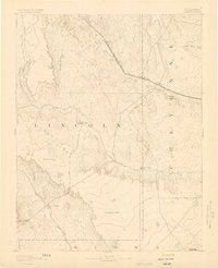
 1891 Arroyo1891 Print · USGSEastern Colorado was still a ranching frontier in the late 1880s as the rail lines expanded across the high plains. Genealogists and historians can trace early holdings like Cox Ranch and Mosley Ranch along the route of the Union Pacific Railroad.
 - 1891 Map of Kit Carson
 1891 Kit Carson1891 Print · USGSThe eastern Colorado plains appear here in the late nineteenth century as a landscape defined by the arrival of the rails. Researchers can trace the early path of the Union Pacific Railroad through the stations at Kit Carson, Wild Horse, and First View.
 - 1892 Map of Cheyenne Wells
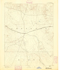
 1892 Cheyenne Wells1892 Print · USGSEastern Colorado during the early frontier era is documented here as the railroad transformed the High Plains. Genealogists and historians can trace the vital iron link of the Union Pacific Railroad through settlements like Cheyenne Wells and Arapahoe.
 - 1893 Map of Arroyo
 1893 Arroyo1893 Print · USGSEastern Colorado was a landscape of isolated cattle ranches and railway outposts during the late nineteenth century. Researchers can locate early family homesteads like Cox Ranch and follow the route of the Union Pacific Railroad through Bovero.4 unique versions available
 - 1893 Map of Kit Carson
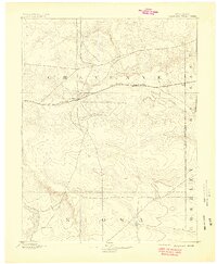
 1893 Kit Carson1893 Print · USGSEastern Colorado during the late nineteenth century was a landscape shaped by rail and river. You can trace the early path of the Union Pacific Railroad through Kit Carson and locate the stations at Wild Horse and First View.5 unique versions available
 - 1894 Map of Cheyenne Wells
 1894 Cheyenne Wells1894 Print · USGSEastern Colorado in the late nineteenth century is a landscape of expansive ranchland defined by the Union Pacific Railroad. Researchers can trace early railroad settlements like Cheyenne Wells and Arapahoe or follow the courses of Ladder Creek and White Woman Creek.6 unique versions available
End of results
Showing maps 1-6 of 6
Top cities of Cheyenne County
Frequently asked questions
- What are the different types of historical maps available for Cheyenne County?
- What is the oldest map of Cheyenne County?
- Where can I purchase historical maps of Cheyenne County for my home or office?
- Where can I download high-res historical maps of Cheyenne County?
- Are there historical topographic maps available for Cheyenne County?
- Is there historical aerial imagery available for Cheyenne County?
- Where are historical maps of Cheyenne County sourced from?