1960s Maps of Cheyenne County, Colorado
Explore 9 historic maps of Cheyenne County from the 1960s. These maps offer a rare glimpse into what life looked like during the 1960s — showing old roads, neighborhoods, homes, and landmarks that have changed or disappeared over time.
Whether you're researching your family's past, planning a metal detecting trip, or studying how Cheyenne County's landscape evolved across the 1960s, these high-resolution maps are a powerful tool for exploring the history of this region.
- Focus on a specific era: All maps on this page are from the 1960s, giving you a focused view of this time period.
- See what’s changed: Compare century-old streets, trails, and buildings to today's modern landscape using overlays and satellite layers.
- Research with precision: Use these maps for genealogy, historical research, land use analysis, or educational projects.
- View, download, or print: Maps are fully viewable online in high resolution, and can be downloaded or printed for your own records.
Start exploring Cheyenne County's history through authentic maps from the 1960s. This is your window into the past.
Cheyenne County, CO maps
(9)- 1969 Map of Arapahoe SE, 1971 Print
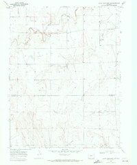
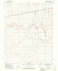 1969 Arapahoe SE1971 Print · USGSThe high plains of the Colorado-Kansas border come into focus in the late sixties, highlighting the vital rail corridor of the Union Pacific. Researchers can trace the path of Ladder Creek and locate numerous family ranch assets including scattered Well sites and surveyed fence lines.
 - 1969 Map of Cheyenne Wells 4 NE, 1971 Print
 1969 Cheyenne Wells 4 NE1971 Print · USGSThe Colorado and Kansas borderlands meet in the late sixties along the winding path of South Ladder Creek. Genealogists and researchers can trace township boundaries and find family-named landmarks like Wells or the remote Colony and Weskan districts.3 unique versions available
 - 1969 Map of Cheyenne Wells 4 SE, 1971 Print
 1969 Cheyenne Wells 4 SE1971 Print · USGSHigh plains life at the Colorado and Kansas border is captured here during the late sixties. Genealogists and local historians can trace the rural landscape near Colony, locating the local Cem and the winding path of White Woman Creek.3 unique versions available
 - 1969 Map of Arapahoe NE, 1971 Print
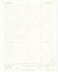
 1969 Arapahoe NE1971 Print · USGSThe High Plains of the Colorado-Kansas border come into focus in the late sixties, where the Smoky Hill River defines the landscape. Genealogists and researchers can trace early water sources like Wells and the terrain of Morton and Weskan.
 - 1969 Map of Mount Sunflower SW, 1972 Print
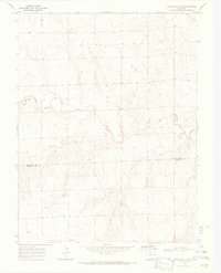
 1969 Mount Sunflower SW1972 Print · USGSHigh plains ranching along the Kansas border comes into focus in the late sixties. Researchers can trace the North Fork Smoky Hill River and locate remote outposts like Beverage Ranch and the Monotony terrain.
 - 1969 Map of Burlington 3 SE, 1972 Print
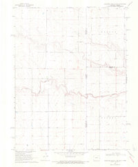
 1969 Burlington 3 SE1972 Print · USGSThe eastern Colorado plains meet the high prairie in the late sixties, where the North Fork Smoky Hill River carves its way through the borderlands. Researchers can trace the section lines across Kit Carson Co and Cheyenne Co to locate numerous named wells and rural roads.5 unique versions available
 - 1969 Map of Mount Sunflower, 1972 Print
 1969 Mount Sunflower1972 Print · USGSThe High Plains border of Colorado and Kansas comes into focus in this late 1960s survey. Genealogists and historians can locate the highest point in Kansas at Mount Sunflower and trace the sparse prairie settlements like Hitchcock and the drainages of Goose Creek.2 unique versions available
 - 1969 Map of Alpine Ranch, 1972 Print
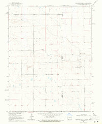
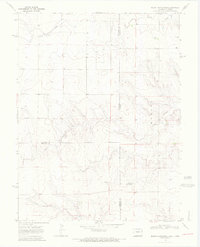
 1969 Alpine Ranch1972 Print · USGSThe eastern Colorado plains at the boundary of Kit Carson and Cheyenne Counties are captured here just before the 1970s. Researchers can trace rural landmarks like Alpine Ranch, the settlement at Perry, and numerous Well sites along the North Fork Smoky Hill River.
 - 1969 Map of Burlington 3 SW, 1972 Print
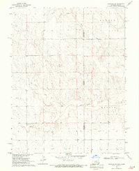
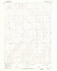
 1969 Burlington 3 SW1972 Print · USGSEastern Colorado ranching country is documented here in the late sixties, where the border of Kit Carson Co and Cheyenne Co meets. Genealogists and researchers can trace the North Fork Smoky Hill River and locate landmarks like Windrift Ranch and several rural wells.5 unique versions available
End of results
Showing maps 1-9 of 9
Top cities of Cheyenne County
Frequently asked questions
- What are the different types of historical maps available for Cheyenne County?
- What is the oldest map of Cheyenne County?
- Where can I purchase historical maps of Cheyenne County for my home or office?
- Where can I download high-res historical maps of Cheyenne County?
- Are there historical topographic maps available for Cheyenne County?
- Is there historical aerial imagery available for Cheyenne County?
- Where are historical maps of Cheyenne County sourced from?