1920s Maps of Garfield County, Colorado
Explore 6 historic maps of Garfield County from the 1920s. These maps offer a rare glimpse into what life looked like during the 1920s — showing old roads, neighborhoods, homes, and landmarks that have changed or disappeared over time.
Whether you're researching your family's past, planning a metal detecting trip, or studying how Garfield County's landscape evolved across the 1920s, these high-resolution maps are a powerful tool for exploring the history of this region.
- Focus on a specific era: All maps on this page are from the 1920s, giving you a focused view of this time period.
- See what’s changed: Compare century-old streets, trails, and buildings to today's modern landscape using overlays and satellite layers.
- Research with precision: Use these maps for genealogy, historical research, land use analysis, or educational projects.
- View, download, or print: Maps are fully viewable online in high resolution, and can be downloaded or printed for your own records.
Start exploring Garfield County's history through authentic maps from the 1920s. This is your window into the past.
Garfield County, CO maps
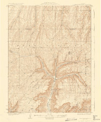
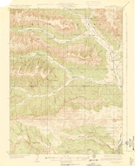
(6)- 1925 Map of Parachute Creek, 1965 Print
 1925 Parachute Creek1965 Print · USGSThe Roan Plateau in the mid-1920s was a center for early energy exploration and high-country ranching. Genealogists and historians can trace industrial outposts like Washington Shale Camp and local education at Granlee School across this mountain landscape.
 - 1927 Map of Parachute Creek
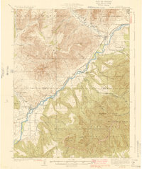
 1927 Parachute Creek1927 Print · USGSThe Book Plateau is shown here during the 1920s oil shale boom, prior to modern industrial development. Researchers can find early industrial outposts like Columbia Shale Camp, the Granlee School, and pioneer sites such as Summers Cabin.3 unique versions available
 - 1927 Map of Glenwood Springs, 1956 Print
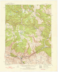 1927 Glenwood Springs1956 Print · USGSGarfield County’s mountain interior comes to life in the 1920s, showing the high-country settlements and early forest service infrastructure across the Colorado River valley. Genealogists can trace family footprints at Sweetwater Lake Sch, the Shoshone Power Plant, and remote outposts like Hip Roof Cabin.3 unique versions available
 - 1929 Map of Grand Valley
 1929 Grand Valley1929 Print · USGSThe Colorado River corridor near the Garfield and Mesa County line reveals a landscape of early oil shale exploration and rail-side growth in the late 1920s. Genealogists can locate family landmarks like Cunningham Ranch and remote schools including Crawford Sch and Battlement Sch.3 unique versions available
 - 1929 Map of Highmore
 1929 Highmore1929 Print · USGSGarfield County’s high plateau country is captured here in the late twenties during a period of mountain ranching and early energy exploration. Researchers can find old homesteads like Denton Cabin, the Good Hope Shale Camp, and the original Highmore PO site.3 unique versions available
 - 1929 Map of Roan Creek
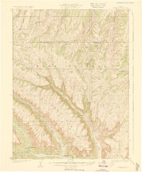
 1929 Roan Creek1929 Print · USGSThe Colorado oil shale country is captured here in the late 1920s as industry and ranching met in the canyons. Researchers can locate remote schools like Dry Fork Sch, the INDEX SHALE PLANT, and early family outposts including Wilcoxson Ranch.3 unique versions available
End of results
Showing maps 1-6 of 6
Top cities of Garfield County
- Glenwood Springs historical maps
- Rifle historical maps
- Carbondale historical maps
- New Castle historical maps
- Silt historical maps
- Parachute historical maps
Frequently asked questions
- What are the different types of historical maps available for Garfield County?
- What is the oldest map of Garfield County?
- Where can I purchase historical maps of Garfield County for my home or office?
- Where can I download high-res historical maps of Garfield County?
- Are there historical topographic maps available for Garfield County?
- Is there historical aerial imagery available for Garfield County?
- Where are historical maps of Garfield County sourced from?