1980s Maps of Garfield County, Colorado
Explore 6 historic maps of Garfield County from the 1980s. These maps offer a rare glimpse into what life looked like during the 1980s — showing old roads, neighborhoods, homes, and landmarks that have changed or disappeared over time.
Whether you're researching your family's past, planning a metal detecting trip, or studying how Garfield County's landscape evolved across the 1980s, these high-resolution maps are a powerful tool for exploring the history of this region.
- Focus on a specific era: All maps on this page are from the 1980s, giving you a focused view of this time period.
- See what’s changed: Compare century-old streets, trails, and buildings to today's modern landscape using overlays and satellite layers.
- Research with precision: Use these maps for genealogy, historical research, land use analysis, or educational projects.
- View, download, or print: Maps are fully viewable online in high resolution, and can be downloaded or printed for your own records.
Start exploring Garfield County's history through authentic maps from the 1980s. This is your window into the past.
Garfield County, CO maps
(6)- 1980 Map of Westwater, 1987 Print
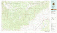 1980 Westwater1987 Print · USGSGrand County, Utah, and western Colorado are captured here in the early 1980s as a landscape of deep canyons and energy extraction. Trace the path of the Denver and Rio Grande Western Railroad or locate landmarks like Westwater Creek and the Cisco Dome Oil Field.2 unique versions available
 - 1981 Map of Grand Junction
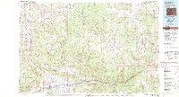
 1981 Grand Junction1981 Print · USGSThe Grand Valley is shown during a period of steady growth in the early eighties, where the desert landscape meets the irrigated orchards of Palisade. Trace the historic Denver and Rio Grande Western Railroad route past the Cameo Mine and into the Book Cliffs.
 - 1981 Map of Douglas Pass, 1982 Print
 1981 Douglas Pass1982 Print · USGSThe high Piceance Basin in the early eighties is a landscape of energy reserves and high-elevation crossings. Researchers can trace the drainages of Douglas Creek and locate remote landmarks like Oil Spring, Baxter Pass, and the Naval Oil Shale Reserve.
 - 1981 Map of Glenwood Springs, 1982 Print
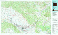
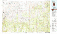
 1981 Glenwood Springs1982 Print · USGSGarfield County in the early eighties was defined by the energy industry and the deep valley of the Colorado River. Genealogists and historians can trace the rail corridor of the Denver and Rio Grande Western through Glenwood Springs and locate industrial landmarks like the Anvil Points Oil Shale Mine.2 unique versions available
 - 1981 Map of Seep Ridge, 1982 Print
 1981 Seep Ridge1982 Print · USGSEastern Utah at the start of the 1980s reveals a high-desert landscape of energy reserves and tribal lands. Researchers can trace the remnants of Watson (Site), the settlement at Rainbow, and the federal footprint of Naval Oil Shale Reserve No 2.2 unique versions available
 - 1982 Map of Carbondale, 1983 Print
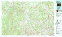
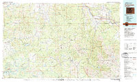 1982 Carbondale1983 Print · USGSThe Roaring Fork Valley and Colorado River corridor are captured here in the early eighties as ranching and mountain industry shaped the landscape. Genealogists and historians can trace the paths of the Denver and Rio Grande Western through old settlements like Satank, Redstone, and Marble.
End of results
Showing maps 1-6 of 6
Top cities of Garfield County
- Glenwood Springs historical maps
- Rifle historical maps
- Carbondale historical maps
- New Castle historical maps
- Silt historical maps
- Parachute historical maps
Frequently asked questions
- What are the different types of historical maps available for Garfield County?
- What is the oldest map of Garfield County?
- Where can I purchase historical maps of Garfield County for my home or office?
- Where can I download high-res historical maps of Garfield County?
- Are there historical topographic maps available for Garfield County?
- Is there historical aerial imagery available for Garfield County?
- Where are historical maps of Garfield County sourced from?