1920s Maps of Routt County, Colorado
Explore 8 historic maps of Routt County from the 1920s. These maps offer a rare glimpse into what life looked like during the 1920s — showing old roads, neighborhoods, homes, and landmarks that have changed or disappeared over time.
Whether you're researching your family's past, planning a metal detecting trip, or studying how Routt County's landscape evolved across the 1920s, these high-resolution maps are a powerful tool for exploring the history of this region.
- Focus on a specific era: All maps on this page are from the 1920s, giving you a focused view of this time period.
- See what’s changed: Compare century-old streets, trails, and buildings to today's modern landscape using overlays and satellite layers.
- Research with precision: Use these maps for genealogy, historical research, land use analysis, or educational projects.
- View, download, or print: Maps are fully viewable online in high resolution, and can be downloaded or printed for your own records.
Start exploring Routt County's history through authentic maps from the 1920s. This is your window into the past.
Routt County, CO maps
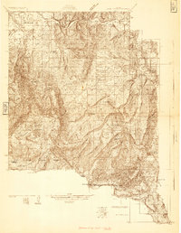
(8)- 1920 Map of Daton Peak
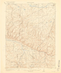 1920 Daton Peak1920 Print · USGSNorthwest Colorado in the era of early mountain ranching and coal mining features a landscape of isolated homesteads and high peaks. Genealogists and historians can trace family-named sites like Jim Dunns Mine, Cary Ranch, and the Pagoda School.2 unique versions available
 - 1923 Map of Elkhead Creek, 1955 Print
 1923 Elkhead Creek1955 Print · USGSMoffat and Routt counties in the early 1920s reveal a landscape of mountain ranching and coal mining before modern development. Genealogists can trace a network of one-room schoolhouses like Dry Fork School and Elkhead School, or locate old family claims near Seymour Mine.5 unique versions available
 - 1923 Map of Pilot Knob, 1958 Print
 1923 Pilot Knob1958 Print · USGSRoutt County mountain life and early industry are captured here in the early 1920s, showing the high-altitude parks and remote schoolhouses of the period. Genealogists and researchers can trace rural homesteads near Gantts Cabin, several early mines like the Ducey Mine, and small community centers like Deep Creek School.4 unique versions available
 - 1924 Map of Elkhead Creek
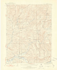
 1924 Elkhead Creek1924 Print · USGSNorthwest Colorado in the 1920s was a landscape of remote coal mines and scattered one-room schoolhouses along the Yampa River. Genealogists can trace family roots through numerous sites like Elkhead School, the Seymour Mine, and the Bears Ears Ranger Station.2 unique versions available
 - 1924 Map of Mt. Harris
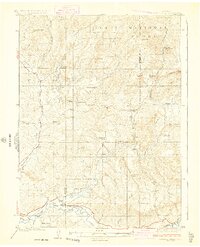
 1924 Mt. Harris1924 Print · USGSRoutt County coal country and the Yampa River valley are captured in the mid-twenties, showing the rise of rail-side settlements and mining camps. Trace early homesteads and community hubs like Coal View, Pinnacle PO, and the Chicago Mine.4 unique versions available
 - 1925 Map of Pilot Knob
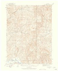
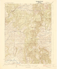 1925 Pilot Knob1925 Print · USGSRoutt County in the early twenties reveals a landscape of high-altitude parks and remote mountain mining. Genealogists and researchers can trace early rural life through Gantts Cabin, the Long Gulch School, and the Ducey Mine.2 unique versions available
 - 1926 Map of Mount Harris
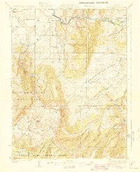 1926 Mount Harris1926 Print · USGSRoutt County's coal and ranching country comes alive in the mid-1920s as the Denver and Salt Lake railroad follows the Yampa River. Genealogists and historians can trace the foundations of local life through rural schools like Windy Point School and vanished mining-era stops such as Coal View.2 unique versions available
 - 1927 Map of Glenwood Springs, 1956 Print
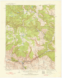 1927 Glenwood Springs1956 Print · USGSGarfield County’s mountain interior comes to life in the 1920s, showing the high-country settlements and early forest service infrastructure across the Colorado River valley. Genealogists can trace family footprints at Sweetwater Lake Sch, the Shoshone Power Plant, and remote outposts like Hip Roof Cabin.3 unique versions available
End of results
Showing maps 1-8 of 8
Top cities of Routt County
- Steamboat Springs historical maps
- Hayden historical maps
- Oak Creek historical maps
- Yampa historical maps
- Phippsburg historical maps
Frequently asked questions
- What are the different types of historical maps available for Routt County?
- What is the oldest map of Routt County?
- Where can I purchase historical maps of Routt County for my home or office?
- Where can I download high-res historical maps of Routt County?
- Are there historical topographic maps available for Routt County?
- Is there historical aerial imagery available for Routt County?
- Where are historical maps of Routt County sourced from?