1980s Maps of Routt County, Colorado
Explore 9 historic maps of Routt County from the 1980s. These maps offer a rare glimpse into what life looked like during the 1980s — showing old roads, neighborhoods, homes, and landmarks that have changed or disappeared over time.
Whether you're researching your family's past, planning a metal detecting trip, or studying how Routt County's landscape evolved across the 1980s, these high-resolution maps are a powerful tool for exploring the history of this region.
- Focus on a specific era: All maps on this page are from the 1980s, giving you a focused view of this time period.
- See what’s changed: Compare century-old streets, trails, and buildings to today's modern landscape using overlays and satellite layers.
- Research with precision: Use these maps for genealogy, historical research, land use analysis, or educational projects.
- View, download, or print: Maps are fully viewable online in high resolution, and can be downloaded or printed for your own records.
Start exploring Routt County's history through authentic maps from the 1980s. This is your window into the past.
Routt County, CO maps
(9)- 1980 Map of Lynx Pass
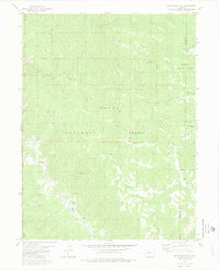
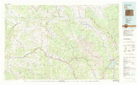
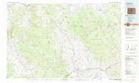
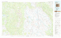
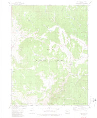 1980 Lynx Pass1980 Print · USGSThe Colorado high country of the Routt National Forest is captured here in the early eighties, showcasing a landscape of high passes and timbered parks. Researchers can trace the Deadman Trail (Pack) and locate remote landmarks like the Guard Sta, Lagunita Lake, and Muddy Slide.4 unique versions available
 - 1980 Map of Gore Mountain
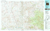
 1980 Gore Mountain1980 Print · USGSThe Colorado wilderness at the turn of the 1980s reveals a landscape of high peaks and hidden drainages along the Routt and Grand Co line. Trace old routes including a Pack Trail and Jeep Trail as they navigate the slopes of Gore Mountain.2 unique versions available
 - 1980 Map of Vail, 1982 Print
 1980 Vail1982 Print · USGSThe Eagle River valley and the Gore Range are shown here in the early eighties as mountain towns evolved from mining hubs to world-class destinations. Trace the Denver and Rio Grande Western railroad or locate the Lady Belle Mine and Johnson Mine.
 - 1980 Map of Steamboat Springs, 1982 Print
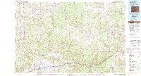
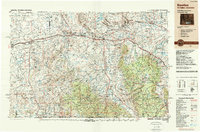
 1980 Steamboat Springs1982 Print · USGSNorthwest Colorado's ranching and rail corridors come to life in the early eighties as mountain recreation and resource management began to reshape the region. Researchers can trace the Denver and Rio Grande Western line through Oak Creek or locate local landmarks like Old Homestead and Egeria Park.
 - 1981 Map of Glenwood Springs, 1982 Print
 1981 Glenwood Springs1982 Print · USGSGarfield County in the early eighties was defined by the energy industry and the deep valley of the Colorado River. Genealogists and historians can trace the rail corridor of the Denver and Rio Grande Western through Glenwood Springs and locate industrial landmarks like the Anvil Points Oil Shale Mine.2 unique versions available
 - 1981 Map of Walden, 1982 Print
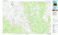
 1981 Walden1982 Print · USGSThe North Park basin in the early eighties was a high-country crossroads of ranching and industry. Researchers can trace the Union Pacific rail corridor and locate historical mining operations like the Sudduth Mine or the remote settlement of Coalmont.
 - 1982 Map of Saratoga
 1982 Saratoga1982 Print · USGSHigh country ranching and mining define this southern Wyoming region during the early 1980s. Researchers can trace the Union Pacific Railroad corridor through Foxpark or locate the historic Ferris-Haggarty Mine near the North Platte River.
 - 1983 Map of Baggs
 1983 Baggs1983 Print · USGSSettlement along the Wyoming-Colorado border in the early eighties follows the path of the Little Snake River through Carbon and Moffat counties. Researchers can trace the path of the Overland Trail or locate historical mining sites like the Ferris-Haggarty Mine and Standard Mine.
 - 1988 Map of Rawlins
 1988 Rawlins1988 Print · USGSSouthern Wyoming and the Colorado borderlands are detailed here in the late eighties, featuring the intersection of the historic Overland Trail and the Union Pacific. Researchers can trace old rail towns like Medicine Bow and Wamsutter or landmark peaks like Medicine Bow Peak.
End of results
Showing maps 1-9 of 9
Top cities of Routt County
- Steamboat Springs historical maps
- Hayden historical maps
- Oak Creek historical maps
- Yampa historical maps
- Phippsburg historical maps
Frequently asked questions
- What are the different types of historical maps available for Routt County?
- What is the oldest map of Routt County?
- Where can I purchase historical maps of Routt County for my home or office?
- Where can I download high-res historical maps of Routt County?
- Are there historical topographic maps available for Routt County?
- Is there historical aerial imagery available for Routt County?
- Where are historical maps of Routt County sourced from?