1910s Maps of Weld County, Colorado
Explore 3 historic maps of Weld County from the 1910s. These maps offer a rare glimpse into what life looked like during the 1910s — showing old roads, neighborhoods, homes, and landmarks that have changed or disappeared over time.
Whether you're researching your family's past, planning a metal detecting trip, or studying how Weld County's landscape evolved across the 1910s, these high-resolution maps are a powerful tool for exploring the history of this region.
- Focus on a specific era: All maps on this page are from the 1910s, giving you a focused view of this time period.
- See what’s changed: Compare century-old streets, trails, and buildings to today's modern landscape using overlays and satellite layers.
- Research with precision: Use these maps for genealogy, historical research, land use analysis, or educational projects.
- View, download, or print: Maps are fully viewable online in high resolution, and can be downloaded or printed for your own records.
Start exploring Weld County's history through authentic maps from the 1910s. This is your window into the past.
Weld County, CO maps
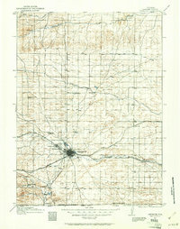
(3)- 1910 Map of Eaton
 1910 Eaton1910 Print · USGSNorthern Colorado at the turn of the century shows a landscape transformed by railroads and early irrigation projects. Genealogists can locate many family-named landmarks like Slaxton Ranch and rural schoolhouses including Abbot School and Birch School.3 unique versions available
 - 1911 Map of Cheyenne, 1961 Print
 1911 Cheyenne1961 Print · USGSCheyenne was a bustling rail and military center in the years before the Great War. Genealogists and historians can trace the footprint of Fort D.A. Russell and find early rural sites like Campstool and Paola.
 - 1914 Map of Cheyenne
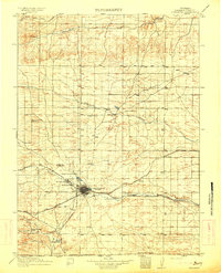 1914 Cheyenne1914 Print · USGSCheyenne stands at the crossroads of three major railroads in the years before the Great War. Researchers can trace the layout of the Fort D.A. Russell Military Reservation and find local landmarks like Ridley School and Campstool.3 unique versions available
End of results
Showing maps 1-3 of 3
Top cities of Weld County
- Greeley historical maps
- Evans historical maps
- Firestone historical maps
- Frederick historical maps
- Severance historical maps
- Fort Lupton historical maps
See more
Frequently asked questions
- What are the different types of historical maps available for Weld County?
- What is the oldest map of Weld County?
- Where can I purchase historical maps of Weld County for my home or office?
- Where can I download high-res historical maps of Weld County?
- Are there historical topographic maps available for Weld County?
- Is there historical aerial imagery available for Weld County?
- Where are historical maps of Weld County sourced from?