1940s Maps of Weld County, Colorado
Explore 4 historic maps of Weld County from the 1940s. These maps offer a rare glimpse into what life looked like during the 1940s — showing old roads, neighborhoods, homes, and landmarks that have changed or disappeared over time.
Whether you're researching your family's past, planning a metal detecting trip, or studying how Weld County's landscape evolved across the 1940s, these high-resolution maps are a powerful tool for exploring the history of this region.
- Focus on a specific era: All maps on this page are from the 1940s, giving you a focused view of this time period.
- See what’s changed: Compare century-old streets, trails, and buildings to today's modern landscape using overlays and satellite layers.
- Research with precision: Use these maps for genealogy, historical research, land use analysis, or educational projects.
- View, download, or print: Maps are fully viewable online in high resolution, and can be downloaded or printed for your own records.
Start exploring Weld County's history through authentic maps from the 1940s. This is your window into the past.
Weld County, CO maps
(4)- 1949 Map of Gowanda, 1957 Print
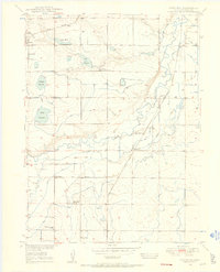 1949 Gowanda1957 Print · USGSWeld County’s mid-century farming landscape is captured here, showing the intricate water and rail networks before modern development altered the valley. Genealogists and historians can trace local landmarks like the Rinn Valley Grange, Stone School, and the Union Pacific rail corridor.6 unique versions available
 - 1949 Map of Fort Lupton, 1964 Print
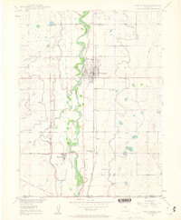 1949 Fort Lupton1964 Print · USGSNortheastern Colorado agriculture and transit come alive in this post-war survey of the Platte River valley. Genealogists and historians can trace the footprint of rural life through Hillside Cemetery, Wattenberg Sch, and the Union Pacific rail line.6 unique versions available
 - 1949 Map of Platteville, 1966 Print
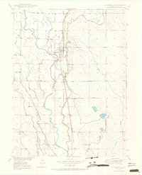 1949 Platteville1966 Print · USGSThe Colorado plains near the South Platte River are shown here in the late 1940s, highlighting a landscape defined by irrigation and rail. Researchers can trace the Union Pacific corridor through Platteville, find St Francis Cemetery, and locate the Site of Old Fort Vasquez.5 unique versions available
 - 1949 Map of Hudson, 1967 Print
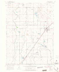 1949 Hudson1967 Print · USGSHudson and the surrounding Weld County prairie are captured here in the late 1940s, showing a landscape defined by rail and irrigation. Genealogists and local historians can locate Mountain View Cem, the community of Tonville, and various waterworks like the Beebe Canal.8 unique versions available
End of results
Showing maps 1-4 of 4
Top cities of Weld County
- Greeley historical maps
- Evans historical maps
- Firestone historical maps
- Frederick historical maps
- Severance historical maps
- Fort Lupton historical maps
See more
Frequently asked questions
- What are the different types of historical maps available for Weld County?
- What is the oldest map of Weld County?
- Where can I purchase historical maps of Weld County for my home or office?
- Where can I download high-res historical maps of Weld County?
- Are there historical topographic maps available for Weld County?
- Is there historical aerial imagery available for Weld County?
- Where are historical maps of Weld County sourced from?