1960s Maps of Weld County, Colorado
Explore 22 historic maps of Weld County from the 1960s. These maps offer a rare glimpse into what life looked like during the 1960s — showing old roads, neighborhoods, homes, and landmarks that have changed or disappeared over time.
Whether you're researching your family's past, planning a metal detecting trip, or studying how Weld County's landscape evolved across the 1960s, these high-resolution maps are a powerful tool for exploring the history of this region.
- Focus on a specific era: All maps on this page are from the 1960s, giving you a focused view of this time period.
- See what’s changed: Compare century-old streets, trails, and buildings to today's modern landscape using overlays and satellite layers.
- Research with precision: Use these maps for genealogy, historical research, land use analysis, or educational projects.
- View, download, or print: Maps are fully viewable online in high resolution, and can be downloaded or printed for your own records.
Start exploring Weld County's history through authentic maps from the 1960s. This is your window into the past.
Weld County, CO maps
(22)- 1960 Map of Cobb Lake, 1962 Print
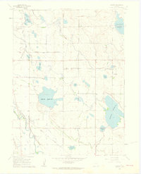
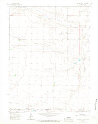
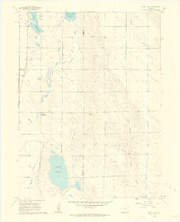 1960 Cobb Lake1962 Print · USGSWellington and the surrounding High Plains of Colorado are captured here in the early sixties, showing a landscape defined by vital water systems. Researchers can trace the Windsor Ditch, locate the Highland Cem, and explore the contours of Cactus Hill.5 unique versions available
 - 1960 Map of Severance, 1962 Print
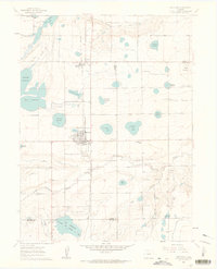
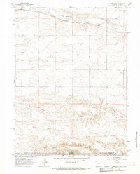
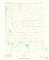 1960 Severance1962 Print · USGSThe agricultural and energy landscape of Weld County comes into focus in the early sixties, centered on the town of Severance. Researchers can trace old irrigation systems like the Great Western Canal and locate the historic Smith Sch or Black Hollow Oil Field.3 unique versions available
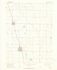
 - 1960 Map of Purcell, 1962 Print
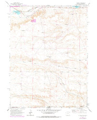
 1960 Purcell1962 Print · USGSPurcell and the surrounding Weld County high plains are captured here in the early sixties, showing a landscape defined by ranching and rail history. Trace the Old Railroad Grade past the Prairie View Sch and seasonal waters like Coal Creek.
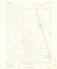
 - 1960 Map of Eaton, 1962 Print
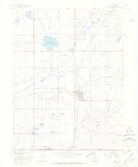
 1960 Eaton1962 Print · USGSThe agricultural heart of Weld County is on display in the early sixties, centered on the growing towns of Ault and Eaton. Genealogists and researchers can trace local landmarks like Wyatt Sch, the Barnett Airfield, and the Union Pacific rail line.4 unique versions available
 - 1960 Map of Nunn, 1962 Print
 1960 Nunn1962 Print · USGSWeld County’s high plains are captured here in the early 1960s, documenting the rail-side development of Nunn and Pierce. Genealogists and local historians can trace the foundations of these communities through the High Sch, Mountain View Cem, and the Union Pacific rail line.
 - 1960 Map of Galeton, 1962 Print
 1960 Galeton1962 Print · USGSThe high-plains agricultural hub of Galeton is captured here in the early sixties, showing its reliance on the railroad and complex irrigation. Genealogists and historians can trace the Union Pacific tracks, the Old Railroad Grade, and local water landmarks like Mason Reservoir.3 unique versions available
 - 1960 Map of Timnath, 1962 Print
 1960 Timnath1962 Print · USGSTimnath and the surrounding Colorado farm country are captured here at the dawn of the 1960s, defined by a complex network of irrigation canals and reservoirs. Genealogists and local historians can locate the Timnath Cem, Boxelder Sch, and rail-side settlements like Kluver and Kerns.4 unique versions available
 - 1960 Map of Antelope Reservoir, 1962 Print
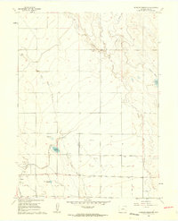 1960 Antelope Reservoir1962 Print · USGSWeld County’s agricultural and energy landscape comes into focus during the early sixties, centered on the railroad town of Pierce. Researchers can trace the extensive irrigation network through the Pierce Lateral and locate operations within the Pierce Oil Field.2 unique versions available
 - 1960 Map of Berthoud, 1963 Print
 1960 Berthoud1963 Print · USGSNorthern Colorado's agricultural heartland comes into focus in the early sixties, showing the vital irrigation networks surrounding Berthoud. Trace family roots at Greenlawn Cem or locate early landmarks like Campion Academy and the Old Berthoud Sch.9 unique versions available
 - 1961 Map of Greeley
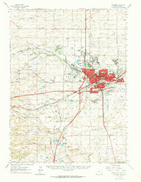
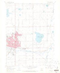
 1961 Greeley1961 Print · USGSNorthern Colorado's transition from high mountain peaks to irrigated plains is captured here just as the post-war population boom reached the Front Range. Researchers can trace early water infrastructure and rail lines like the Great Western RR connecting sugar beet hubs from Fort Collins to Greeley.
 - 1961 Map of Cheyenne South, 1963 Print
 1961 Cheyenne South1963 Print · USGSThe southern outskirts of Cheyenne in the early sixties reveal a landscape of emerging neighborhoods and essential rail hubs. Genealogists and historians can trace the foundations of Orchard Valley and locate landmarks like the Full Gospel Tabernacle and Intermountain Speedway.3 unique versions available
 - 1961 Map of Cheyenne, 1964 Print
 1961 Cheyenne1964 Print · USGSCheyenne and its surrounding high plains are captured here in the early sixties, showing a period of significant military and rail infrastructure. Genealogists and historians can locate old landmarks like Lakeview Cem, the USDA Horticultural Field Station, and early settlements such as Borie and Speer.
 - 1963 Map of Arcola, 1967 Print
 1963 Arcola1967 Print · USGSThe high plains along the Wyoming-Colorado border are captured here in the early sixties, centered on the railroad crossing at Arcola. Researchers can trace the path of the Chicago Burlington and Quincy and locate landmarks like the Beaver Dam Ditch and Porter Creek.
 - 1963 Map of Pine Bluffs SE, 1967 Print
 1963 Pine Bluffs SE1967 Print · USGSThe High Plains borderlands of Wyoming, Nebraska, and Colorado come into focus in the early sixties, showing a landscape shaped by ranching and resource transport. Researchers can trace the sharp escarpment of Pine Bluffs and locate isolated landmarks like a Shed or the long path of the southern Pipeline.3 unique versions available
 - 1963 Map of Carpenter, 1967 Print
 1963 Carpenter1967 Print · USGSThe high plains borderland between Wyoming and Colorado comes into focus in the early sixties, showing the rail-dependent town of Carpenter. Genealogists and local historians can trace the Chicago Burlington and Quincy railroad and the local Cem.
 - 1963 Map of Pine Bluffs SW, 1967 Print
 1963 Pine Bluffs SW1967 Print · USGSThe high plains along the Wyoming and Colorado border appear in the early sixties as a landscape of isolated ranching and aviation. Genealogists and local historians can trace family-named sites like Kelly Ranch and the isolated Butler Landing Strip.
 - 1963 Map of Campstool, 1967 Print
 1963 Campstool1967 Print · USGSThe Wyoming and Colorado borderlands in the early sixties reveal a landscape of remote ranching outposts and high-plains drainages. Researchers can trace the legacy of the livestock industry through sites like West Porter Cow Camp, East Porter Cow Camp, and the Chalk Bluffs.2 unique versions available
 - 1963 Map of Altvan, 1978 Print
 1963 Altvan1978 Print · USGSThe Wyoming and Colorado borderlands in the early sixties reveal a complex landscape of ranching and water rights. Researchers can trace historical property boundaries and livestock infrastructure through Altvan and along the Burlington Northern line, identifying named landmarks like the Century Windmill and Stewart DITCH.
 - 1964 Map of Greeley
 1964 Greeley1964 Print · USGSThe Front Range corridor and high peaks of the Rockies appear here in the mid-1960s, showing the intersection of mountain wilderness and plains agriculture. Trace the rail routes of the Great Western RR or locate landmarks like Longs Peak and Horsetooth Reservoir.
 - 1965 Map of Greeley
 1965 Greeley1965 Print · USGSNorthern Colorado in the mid-sixties shows a landscape defined by high mountain summits and the growing irrigation networks of the plains. Genealogists and historians can trace rail-side towns like Wellington or follow the early tracks of the Union Pacific Railroad past Longs Peak.
 - 1967 Map of Erie, 1968 Print
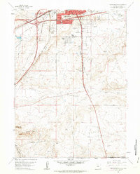
 1967 Erie1968 Print · USGSThe northern Front Range comes alive in this late 1960s survey of the coal and rail corridors between Weld and Boulder Counties. Genealogists and historians can trace the early footprints of Erie and Lafayette, alongside landmarks like the Columbine Mine and the Mountain View Drag Strip.6 unique versions available
 - 1968 Map of Longmont
 1968 Longmont1968 Print · USGSLongmont and the surrounding farm country are captured here in the late sixties, highlighting the vital irrigation networks of the Colorado plains. Researchers can trace family roots at Burlington Cem, locate the old Grange Hall, or map the paths of the Chicago Burlington and railroad.6 unique versions available
End of results
Showing maps 1-22 of 22
Top cities of Weld County
- Greeley historical maps
- Evans historical maps
- Firestone historical maps
- Frederick historical maps
- Severance historical maps
- Fort Lupton historical maps
See more
Frequently asked questions
- What are the different types of historical maps available for Weld County?
- What is the oldest map of Weld County?
- Where can I purchase historical maps of Weld County for my home or office?
- Where can I download high-res historical maps of Weld County?
- Are there historical topographic maps available for Weld County?
- Is there historical aerial imagery available for Weld County?
- Where are historical maps of Weld County sourced from?