1900s (20th Century) Maps of Kent County, Delaware
Explore 90 historic maps of Kent County from the 1900s (20th Century). These maps offer a rare glimpse into what life looked like during the 1900s — showing old roads, neighborhoods, homes, and landmarks that have changed or disappeared over time.
Whether you're researching your family's past, planning a metal detecting trip, or studying how Kent County's landscape evolved across the 1900s, these high-resolution maps are a powerful tool for exploring the history of this region.
- Focus on a specific era: All maps on this page are from the 1900s, giving you a focused view of this time period.
- See what’s changed: Compare century-old streets, trails, and buildings to today's modern landscape using overlays and satellite layers.
- Research with precision: Use these maps for genealogy, historical research, land use analysis, or educational projects.
- View, download, or print: Maps are fully viewable online in high resolution, and can be downloaded or printed for your own records.
Start exploring Kent County's history through authentic maps from the 1900s. This is your window into the past.
Kent County, DE maps
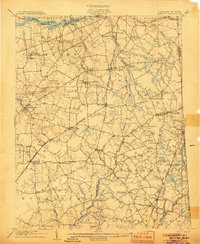
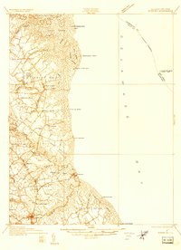
(90)- 1900 Map of Cecilton
 1900 Cecilton1900 Print · USGSUpper Chesapeake life at the turn of the century was defined by the deep tidal necks of the Sassafras River. You can trace old steamboat landings like Wilson Point Whf. and rural rail stops along the Baltimore and Delaware Bay R. R.6 unique versions available
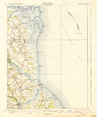
 - 1905 Map of Barclay
 1905 Barclay1905 Print · USGSUpper Delmarva at the start of the twentieth century was a landscape of rail-connected farming towns and river landings. Trace family roots and old property lines near Sudlersville, the Ashland Hayden P O, and the Benedictine Convent.3 unique versions available
 - 1906 Map of Dover
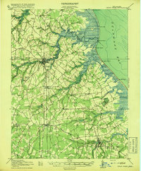
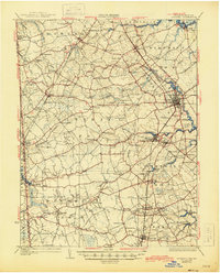
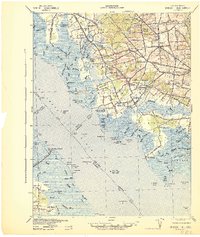
 1906 Dover1906 Print · USGSCentral Delaware and Maryland's Eastern Shore appear at the start of the twentieth century, focused on the bustling rail-and-river economy. Genealogists can trace old family landing sites and crossroads villages like Bohemia Mills, Deakyneville Ldg., and Seven Hickories.3 unique versions available
 - 1918 Map of Cedar Creek
 1918 Cedar Creek1918 Print · USGSDelaware's bay coast during the Great War era reveals a landscape of tidal marshes and remote beach landings. Researchers can trace rural Sussex County life through sites like Old Baptist Ch, Mispillion River LH, and the P. B. and W. RR.2 unique versions available
 - 1918 Map of Harrington
 1918 Harrington1918 Print · USGSThe Kent and Sussex County borderlands at the end of the Great War reveal a landscape of busy rail corridors and small schoolhouses. Researchers can trace the legacy of rural education at Union Chapel School or locate family roots near Harrington and Hickman.4 unique versions available
 - 1918 Map of Cape Henlopen
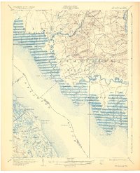
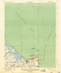
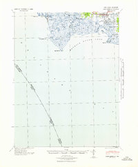
 1918 Cape Henlopen1918 Print · USGSCoastal Sussex County is seen here at a pivotal maritime moment, as the bustling port at Lewes manages the traffic of the Delaware Bay. Researchers can trace early twentieth-century rail lines, the historic Cape Henlopen Light, and local landmarks like West Hill School.2 unique versions available
 - 1919 Map of Cedar Creek
 1919 Cedar Creek1919 Print · USGSSussex County's coastal necks and rail towns are captured here at the end of the Great War. Genealogists can trace family schoolhouses like Cave Neck School and Slaughter Neck School or locate old water-powered sites such as Marshall Mill Pond.
 - 1919 Map of Vineland, 1921 Print
 1919 Vineland1921 Print · USGSCumberland County’s coastal oyster ports and inland industrial centers are captured here during a period of peak maritime activity. Genealogists and historians can trace rail lines like the Central R. R. of New Jersey or locate vanished sites like Whitehall Ldg. and Sheppards Mill.
 - 1920 Map of Dover
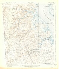
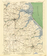
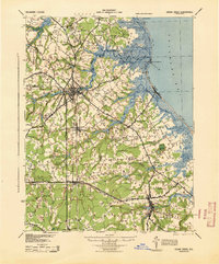
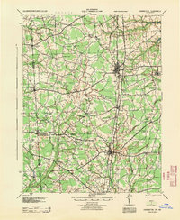
 1920 Dover1920 Print · USGSThe Maryland and Delaware borderlands at the end of the Great War reveal a landscape of tidewater landings and evolving rail lines. Trace family roots and vanished wharves through Fredericktown, the Mason and Dixon Line, and the Bombay Hook Light.
 - 1926 Map of Wyoming
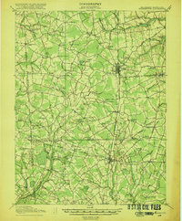
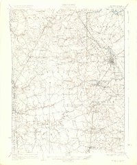
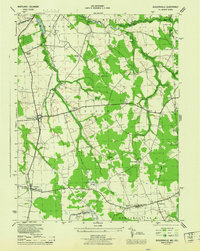
 1926 Wyoming1926 Print · USGSCentral Delaware in the mid-twenties shows a landscape defined by the Pennsylvania RR and a dense network of rural schoolhouses. Researchers can locate family landmarks at Wrights Crossroads, Voshell Mill, or the many parish sites like Bryn Zion Church.
 - 1930 Map of Wyoming, 1945 Print
 1930 Wyoming1945 Print · USGSCentral Delaware in the mid-1920s reveals a structured landscape of rural school districts and railroad-connected towns surrounding the capital. Genealogists and historians can trace family locations near landmarks like Voshell Mill, the County Poor Farm, or many rural schoolhouses like Lockwood Sch.
 - 1931 Map of Wyoming
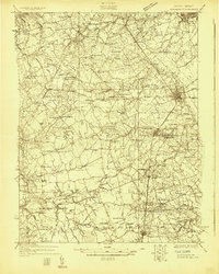
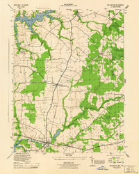
 1931 Wyoming1931 Print · USGSKent County and the Maryland borderlands are seen here between the world wars, a landscape of rail-connected towns and rural districts. Genealogists can trace family lines through numerous sites like Dinaus Corner, the County Poor Farm, and Bethel church.2 unique versions available
 - 1931 Map of Bay Side
 1931 Bay Side1931 Print · USGSThe tidal marshes of the lower Delaware River come alive in the early thirties, showcasing the maritime and agricultural roots of South Jersey. Genealogists and historians can trace family-named sites like Maskell Mill, the rail path of the Southern Jersey R R, and old bayfront landings at Sea Breeze.2 unique versions available
 - 1931 Map of Smyrna
 1931 Smyrna1931 Print · USGSCoastal Delaware in the late twenties and early thirties was a landscape of tidal landings and crossroads settlements linked by the new Dupont Highway. Genealogists can trace family names across Gums Corners, identify sites like St Anns Church, or locate the many landings along Blackbird Creek, including Blackbird Landing and Stave Landing.5 unique versions available
 - 1934 Map of Bowers
 1934 Bowers1934 Print · USGSCoastal Kent County in the mid-1930s is a landscape of tidal marshes and tight-knit farming communities tied to the bay. Researchers can trace ancestral roots at Barratts Chapel, find rural schoolhouses like St Jones Sch, and locate old river settlements like Barkers Landing.
 - 1936 Map of Bowers
 1936 Bowers1936 Print · USGSCoastal Kent County appears in the mid-1930s as a landscape of tidal marshes, small farming districts, and vital river landings. Genealogists can trace family footprints through sites like Barretts Chapel, Barkers Landing, and rural schools like Cowgill Sch.4 unique versions available
 - 1937 Map of Cape Henlopen
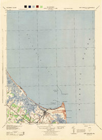
 1937 Cape Henlopen1937 Print · USGSThe Delaware coastline near Cape Henlopen comes alive in the early twentieth century, showing a landscape defined by maritime safety and rail transport. Trace the routes of the Pennsylvania RR to settlements like Lewes or locate landmarks such as the West Hill School and Cape Henlopen Light.2 unique versions available
 - 1938 Map of Cedar Creek
 1938 Cedar Creek1938 Print · USGSCoastal Sussex County in the late 1930s shows a landscape of tidal necks and millponds connected by the P B AND W RR. Genealogists can trace family footprints across dozens of local school sites like Wesleys School and the Old Baptist Church.2 unique versions available
 - 1941 Map of Port Norris
 1941 Port Norris1941 Print · USGSCumberland County's maritime heart is captured here during the early 1940s, as the oyster industry centered on Bivalve and Port Norris reached its mid-century peak. Researchers can trace the Reading Seashore Lines to the coast or locate remote outposts like Fortescue and Matts Landing.
 - 1941 Map of Shiloh
 1941 Shiloh1941 Print · USGSCoastal New Jersey and Delaware meet here at the start of the 1940s, showing a landscape of tidal marshes and rural crossroads. Genealogists and historians can trace family-named corners and vital industries like Seventh Day Mill, the County Almshouse, and the Ship John Shoal Light.
 - 1944 Map of Cedar Creek
 1944 Cedar Creek1944 Print · USGSCoastal Sussex County is documented here during the mid-forties, showing the vital rail and maritime connections of the Delaware Bay shore. Researchers can trace family roots through numerous rural landmarks like Sour Apple Tree Sch, Slaughter Beach, and the Old Baptist Church.
 - 1944 Map of Cape Henlopen
 1944 Cape Henlopen1944 Print · USGSCoastal Delaware during the mid-forties reveals a landscape of vital maritime defense and rural crossroads. Genealogists and historians can trace the Pennsylvania rail line through Lewes and locate landmarks like the West Hill Sch and Coast Guard Sta.
 - 1944 Map of Millington
 1944 Millington1944 Print · USGSUpper Kent County and the Delaware borderlands come alive in the mid-1940s, highlighting a landscape defined by rail junctions and river systems. You can trace family roots through small communities like Golts, Massey, and Crumpton, or locate historic sites like St Clements Church.
 - 1944 Map of Sudlersville
 1944 Sudlersville1944 Print · USGSThe rural borderlands of Maryland and Delaware are captured here in the mid-1940s, centered on the rail corridor at Sudlersville. Researchers can trace old family crossroads like Schenk Corners or locate country sites such as Prices Chapel and Busicks Ch.
 - 1944 Map of Harrington
 1944 Harrington1944 Print · USGSThe Delaware-Maryland borderlands in the mid-1940s are defined here by the Pennsylvania rail line and a high density of rural schoolhouses. Genealogists can trace family names across dozens of crossroads like Minners Corners or locate remote landmarks such as Union Chapel Sch and White Marsh.
Showing maps 1-25 of 90
Top cities of Kent County
- Dover historical maps
- Smyrna historical maps
- Highland Acres historical maps
- Harrington historical maps
- Dover Base historical maps
- Woodside East historical maps
See more
Frequently asked questions
- What are the different types of historical maps available for Kent County?
- What is the oldest map of Kent County?
- Where can I purchase historical maps of Kent County for my home or office?
- Where can I download high-res historical maps of Kent County?
- Are there historical topographic maps available for Kent County?
- Is there historical aerial imagery available for Kent County?
- Where are historical maps of Kent County sourced from?