1990s Maps of Kent County, Delaware
Explore 20 historic maps of Kent County from the 1990s. These maps offer a rare glimpse into what life looked like during the 1990s — showing old roads, neighborhoods, homes, and landmarks that have changed or disappeared over time.
Whether you're researching your family's past, planning a metal detecting trip, or studying how Kent County's landscape evolved across the 1990s, these high-resolution maps are a powerful tool for exploring the history of this region.
- Focus on a specific era: All maps on this page are from the 1990s, giving you a focused view of this time period.
- See what’s changed: Compare century-old streets, trails, and buildings to today's modern landscape using overlays and satellite layers.
- Research with precision: Use these maps for genealogy, historical research, land use analysis, or educational projects.
- View, download, or print: Maps are fully viewable online in high resolution, and can be downloaded or printed for your own records.
Start exploring Kent County's history through authentic maps from the 1990s. This is your window into the past.
Kent County, DE maps
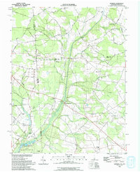
(20)- 1992 Map of Greenwood
 1992 Greenwood1992 Print · USGSThe Delmarva landscape comes alive in the 1990s as it transitions from the rail town of Greenwood to the thick timber of Ellendale State Forest. Researchers can trace the heritage of local settlements like Staytonville and Farmington alongside landmarks like St Johnstown Ch.
 - 1993 Map of Canton
 1993 Canton1993 Print · USGSCoastal Salem County comes into focus in the early nineties, showing a landscape defined by the vast marshlands of the Delaware Bay. Researchers can trace historic crossroads and tide-water landmarks from Harmersville down to Stow Creek Landing and the old milling site at Maskells Mill.
 - 1993 Map of Ben Davis Point
 1993 Ben Davis Point1993 Print · USGSThe coastal reaches of Cumberland County are captured in the early nineties, where the marshy expanse of Back Neck meets the bay. Trace the isolated outposts at Husted Landing and Sea Breeze, or locate the Ben Davis Pt Light marking the shoreline.
 - 1993 Map of Harrington
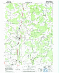
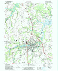
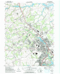
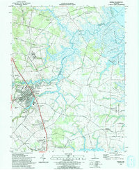
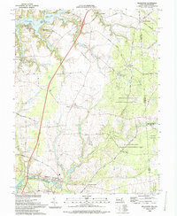
 1993 Harrington1993 Print · USGSHarrington and the surrounding Kent County farm country are shown in the early nineties, centered on the bustling city and its expansive fairgrounds. Genealogists and historians can locate family-named junctions like Melvins Crossroads, rural schools such as Lake Forest Sch, and the quiet village of Houston.
 - 1993 Map of Wyoming
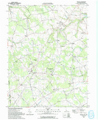
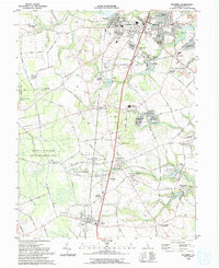 1993 Wyoming1993 Print · USGSCentral Delaware enters the late twentieth century as a mix of traditional rail towns and modern residential parks. Trace family landmarks from the Alms House to Odd Fellows Cem, or follow the Conrail line through Woodside and Viola.
 - 1993 Map of Milford
 1993 Milford1993 Print · USGSMilford and the Kent-Sussex county line appear here in the early nineties, showing a landscape defined by tidewater rivers and growing residential tracts. Trace local landmarks like the historic Abbotts Mill, the Banneker School, and the waters of Silver Lake.
 - 1993 Map of Hickman
 1993 Hickman1993 Print · USGSThe rural borderlands of Delaware and Maryland come to life in this early 1990s survey of the Marshyhope Creek drainage. Researchers can locate family landmarks such as the Ledenham School, Bethel Ch, and the old rail line passing through Hickman.
 - 1993 Map of Dover
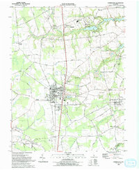
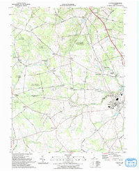
 1993 Dover1993 Print · USGSDover and its surrounding Kent County suburbs are captured here in the early nineties, showing a landscape of rapid residential and civic growth. Researchers can trace family history through sites like Sharon Hills Mem Park, old schoolhouses such as Apple Grove Sch, and established rail-side towns like Cheswold.
 - 1993 Map of Smyrna
 1993 Smyrna1993 Print · USGSSmyrna and the surrounding Delaware wetlands are captured here in the early nineties as suburban expansion began meeting the coastal marshlands. Genealogists and local historians can locate Friendship Ch, trace the banks of Duck Creek, and explore old landings like Smyrna Landing.
 - 1993 Map of Bombay Hook Island
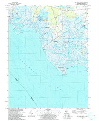
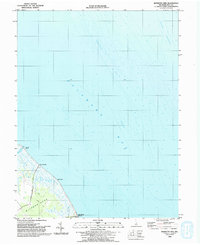
 1993 Bombay Hook Island1993 Print · USGSThe Delaware Bay shoreline in the early 1990s is defined by vast coastal wetlands and managed wildlife habitats. Trace the land use patterns near Woodland Beach and the family-named roads leading to Whitehall and Whitehall Landing.
 - 1993 Map of Bennetts Pier
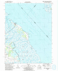
 1993 Bennetts Pier1993 Print · USGSThe Kent County coastline comes into focus in the early nineties, revealing a landscape of tidal marshes and isolated maritime outposts. Genealogists and historians can trace the remote roads to Bennetts Pier and Big Stone Beach or locate the Lookout Tower on Milford Neck.
 - 1993 Map of Mispillion River
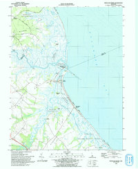 1993 Mispillion River1993 Print · USGSCoastal Sussex County is captured here in the early nineties, where the river meets the bay at the historic Mispillion Light. Researchers can trace local heritage through maritime sites like Fort Saulsbury and old river landings including Revills Landing and Davis Landing.
 - 1993 Map of Millington
 1993 Millington1993 Print · USGSThe Upper Eastern Shore at the start of the nineties reveals a landscape of river landings and wooded management areas. Trace the quiet crossroads of Massey and Golts or locate family sites at St Clements Ch and Shorewood.
 - 1993 Map of Marydel
 1993 Marydel1993 Print · USGSThe Delaware and Maryland borderlands come into focus in the early nineties, revealing a landscape defined by drainage ditches and rural crossroads. Researchers can trace historic local institutions like Thomas Chapel, the legacy of Choptank Mills, and family-named landmarks including Lords Corner and Stantons Cross Road.
 - 1993 Map of Sudlersville
 1993 Sudlersville1993 Print · USGSQueen Anne's County is seen here in the early nineties as a network of crossroads hamlets and family farmsteads along the Delaware line. Genealogists can trace property near Sudlersville and Barclay, or locate old landmarks like Holdens Ch and Unicorn Mill Pond.
 - 1993 Map of Kenton
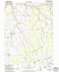
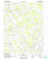
 1993 Kenton1993 Print · USGSWestern Kent County in the early nineties remains a landscape of historic crossroads and small-scale agriculture. Genealogists and local historians can trace family-named intersections such as Fords Corner and Dinahs Corner or locate rural landmarks like Masseys Millpond and Bryn Zion Cem.
 - 1993 Map of Little Creek
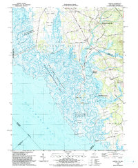
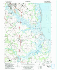
 1993 Little Creek1993 Print · USGSThe Delaware coastline near Little Creek comes to life in the early nineties as the vast marshlands meet the expanding outskirts of Dover. Researchers can trace family sites at Friends Meetinghouse Cem, explore the reaches of Port Mahon, or locate the historic Leipsic River Range Light.
 - 1993 Map of Clayton
 1993 Clayton1993 Print · USGSThe rural borderlands of New Castle and Kent Counties are captured here in the early nineties, centered on the wooded tracts of Blackbird State Forest. Researchers can trace old family locations near Blackiston, Clayton, and Reynolds Corners School.
 - 1993 Map of Burrsville
 1993 Burrsville1993 Print · USGSThe Maryland-Delaware border region in the early nineties is a dense network of agricultural hamlets and named crossroads. Genealogists can trace family names through landmarks like Schultie Crossroads, Manship Ch, and Garey Mill Pond.
 - 1993 Map of Frederica
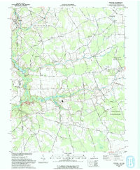
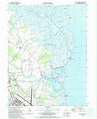
 1993 Frederica1993 Print · USGSThe Kent County coastline in the early nineties features a unique blend of historic river landings and expansive wildlife preserves. Genealogists and local historians can locate Barratts Chapel, the Dickinson Mansion, and bayfront communities like Bowers Beach.
End of results
Showing maps 1-20 of 20
Top cities of Kent County
- Dover historical maps
- Smyrna historical maps
- Highland Acres historical maps
- Harrington historical maps
- Dover Base historical maps
- Woodside East historical maps
See more
Frequently asked questions
- What are the different types of historical maps available for Kent County?
- What is the oldest map of Kent County?
- Where can I purchase historical maps of Kent County for my home or office?
- Where can I download high-res historical maps of Kent County?
- Are there historical topographic maps available for Kent County?
- Is there historical aerial imagery available for Kent County?
- Where are historical maps of Kent County sourced from?