1950s Maps of Kent County, Delaware
Explore 26 historic maps of Kent County from the 1950s. These maps offer a rare glimpse into what life looked like during the 1950s — showing old roads, neighborhoods, homes, and landmarks that have changed or disappeared over time.
Whether you're researching your family's past, planning a metal detecting trip, or studying how Kent County's landscape evolved across the 1950s, these high-resolution maps are a powerful tool for exploring the history of this region.
- Focus on a specific era: All maps on this page are from the 1950s, giving you a focused view of this time period.
- See what’s changed: Compare century-old streets, trails, and buildings to today's modern landscape using overlays and satellite layers.
- Research with precision: Use these maps for genealogy, historical research, land use analysis, or educational projects.
- View, download, or print: Maps are fully viewable online in high resolution, and can be downloaded or printed for your own records.
Start exploring Kent County's history through authentic maps from the 1950s. This is your window into the past.
Kent County, DE maps
(26)- 1951 Map of Cecilton
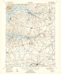 1951 Cecilton1951 Print · USGSThe upper Eastern Shore at mid-century reveals a landscape defined by deep river necks and quiet crossroads. Genealogists can locate family landmarks such as Bohemia Manor, Shrewsbury Ch, and small settlements like Earleville or Galena.2 unique versions available
 - 1951 Map of Barclay
 1951 Barclay1951 Print · USGSMid-century Queen Anne's County is captured here in its prime agricultural era, just as modern drainage was reshaping the Delmarva landscape. Genealogists can trace family names at Hackett Corners or locate landmarks like St Gertrude Academy and the Pennsylvania rail line.2 unique versions available
 - 1953 Map of Sudlersville, 1955 Print
 1953 Sudlersville1955 Print · USGSThe Maryland-Delaware borderlands near the mid-century were defined by a rhythmic landscape of family crossroads and rail-side towns. Genealogists and historians can trace the foundations of local communities through sites like Holdens Ch, Unicorn Mill Pond, and the scattered settlements of Duhamel Corners and Barclay.2 unique versions available
 - 1953 Map of Millington, 1955 Print
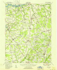
 1953 Millington1955 Print · USGSThe Maryland and Delaware borderlands are captured here in the early 1950s, showing a landscape defined by river landings and rail junctions. Researchers can locate family landmarks at Peacock Corners and Coldwell Corners, or trace the old paths between Golts, Massey, and Millington.3 unique versions available
 - 1954 Map of Milford, 1955 Print
 1954 Milford1955 Print · USGSThe coastal plain of Delaware's Kent and Sussex counties is captured in the mid-fifties, centered on the hub of Milford. Genealogists and historians can trace the evolution of the MISPILLION RIVER waterfront, family landmarks like Abbotts Pond, and the old I O O F Cemetery.3 unique versions available
 - 1955 Map of Wilmington
 1955 Wilmington1955 Print · USGSThe Delaware Valley and Jersey Shore are seen here during the mid-fifties era of rapid suburban expansion and highway development. You can trace the path of the New Jersey Turnpike, locate the Fort Dix Military Reservation, or explore the rail networks of the Pennsylvania Railroad.
 - 1955 Map of Clayton, 1956 Print
 1955 Clayton1956 Print · USGSUpper Delaware in the mid-fifties shows a landscape of rail-connected towns and historic crossroads on the New Castle and Kent County line. Genealogists and local historians can trace family-named hubs like Grears Corners, Thomas Corners, and institutions like the St Joseph Industrial Sch.3 unique versions available
 - 1955 Map of Mispillion River, 1956 Print
 1955 Mispillion River1956 Print · USGSCoastal Sussex County in the mid-fifties is captured here as a network of salt marshes, river landings, and maritime outposts. Genealogists can trace family landmarks like Cedar Neck Ch and Fort Saulsbury, or locate early sites like Majorleys Landing.3 unique versions available
 - 1955 Map of Burrsville, 1956 Print
 1955 Burrsville1956 Print · USGSThe Kent and Caroline county borderlands in the mid-1950s reveal a landscape of interconnected farming hamlets and parish churches. Genealogists can trace family footprints at Hollandsville, Melvin Crossroads, and Manship Ch.2 unique versions available
 - 1955 Map of Hickman, 1957 Print
 1955 Hickman1957 Print · USGSMid-century Sussex County comes into focus in the mid-fifties, showing the farming and drainage patterns along the Maryland border. Genealogists can trace family footprints near Smithville, Dublin Hill, and country houses of worship like Trinity Ch.2 unique versions available
 - 1955 Map of Harrington, 1957 Print
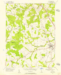
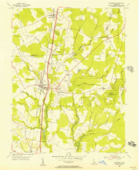
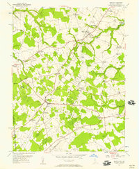
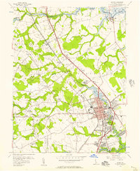
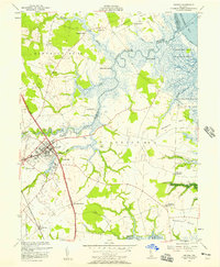
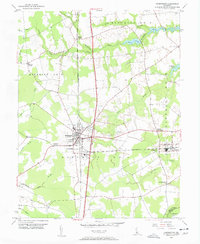 1955 Harrington1957 Print · USGSHarrington and the surrounding Kent County farm country are shown in the mid-fifties at a peak of rail-driven activity. Genealogists and local historians can trace family locations near Reeves Crossing, Houston, and the rural St Mark Ch.3 unique versions available
 - 1955 Map of Greenwood, 1957 Print
 1955 Greenwood1957 Print · USGSCentral Delaware's Sussex County in the mid-fifties shows a landscape of rail-side towns and marshy woodlots. Trace family roots and local landmarks from Greenwood to Staytonville, including St Johnstown Ch and Devils Woodyard.2 unique versions available
 - 1955 Map of Kenton, 1957 Print
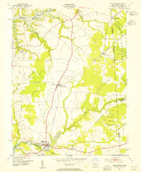
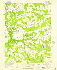
 1955 Kenton1957 Print · USGSWestern Kent County in the mid-1950s is a landscape of thriving rural crossroads and country schools. Genealogists and local historians can trace family-named landmarks like Pearsons Corner, Seven Hickories, and Downes Chapel, alongside the early Lash Airfield.3 unique versions available
 - 1956 Map of Bombay Hook
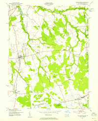
 1956 Bombay Hook1956 Print · USGSThe Delaware coast in the mid-1950s is defined by the wetlands of the Bombay Hook National Wildlife Refuge. Researchers can trace old family lands and waterways like Whitehall Neck, Woodland Beach, and Dutch Neck Canal.4 unique versions available
 - 1956 Map of Fortescue, 1957 Print
 1956 Fortescue1957 Print · USGSCoastal New Jersey meets the Delaware Bay in the mid-1950s, revealing a landscape defined by tidal marshes and maritime life. Researchers can trace the waterfront at Fortescue or locate remote landmarks like Egg Island Point and Wilmas Pond.4 unique versions available
 - 1956 Map of Dover, 1957 Print
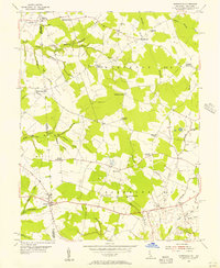
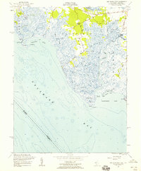
 1956 Dover1957 Print · USGSDover and its surrounding districts are captured mid-century during a period of steady residential and institutional growth. Genealogists and historians can trace family locations near Bishops Corner, old school sites like Fork Branch Sch, and early suburbs like Capitol Park.3 unique versions available
 - 1956 Map of Bennetts Pier, 1957 Print
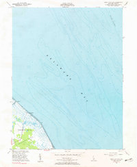 1956 Bennetts Pier1957 Print · USGSAlong the Delaware coast in the mid-1950s, this area of Kent County remained a quiet expanse of marsh and bay. Genealogists and researchers can trace the shoreline at Bennetts Pier, Sandy Pt, and the northern edge of Big Stone Beach.2 unique versions available
 - 1956 Map of Wyoming, 1957 Print
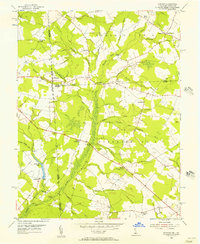
 1956 Wyoming1957 Print · USGSIn the mid-1950s, the rural landscape of central Delaware was characterized by a strong rail-and-water economy. Researchers can trace ancestral locations across Woodside, Viola, and Felton, or locate community landmarks like Voshell Mill and St Johns Ch.3 unique versions available
 - 1956 Map of Smyrna, 1957 Print
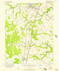
 1956 Smyrna1957 Print · USGSThe town of Smyrna and its surrounding rural districts are shown in the mid-fifties as the local economy balanced rail transport with coastal marsh management. Researchers can trace family-named sites like Belmont Hall or locate rural landmarks such as Friendship Ch and Dutch Neck Crossroads.3 unique versions available
 - 1956 Map of Marydel, 1957 Print
 1956 Marydel1957 Print · USGSThe Maryland-Delaware borderlands come alive in this mid-century survey of rural farm districts and marshland drainage networks. Genealogists can trace family footprints near Thomas Chapel, the Oak Point Sch, and the waters of the Mud Millpond and Choptank River.2 unique versions available
 - 1956 Map of Frederica, 1957 Print
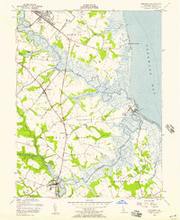 1956 Frederica1957 Print · USGSThe Kent County coastline in the mid-1950s shows a landscape of tidal marshes and river towns before modern development. Genealogists and historians can trace the foundations of Frederica, Bowers, and local landmarks like Barratts Chapel or the Dickinson Mansion.3 unique versions available
 - 1956 Map of Little Creek, 1958 Print
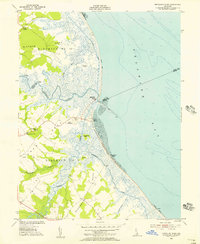
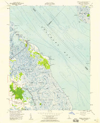
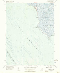
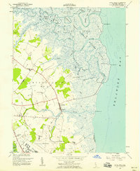 1956 Little Creek1958 Print · USGSThe Kent County coast in the mid-1950s shows a landscape of tidal marshes and military expansion. Genealogists can trace family sites at the Friends Meetinghouse or Moors Cem while exploring the docks at Dona Landing.5 unique versions available
 - 1956 Map of Ben Davis Point, 1958 Print
 1956 Ben Davis Point1958 Print · USGSCoastal Cumberland County is mapped here in the mid-fifties, showing the intricate tidal marshland before the era of modern development. Researchers can trace historic access points like Sea Breeze, the landing at Husted Landing, and the remote Loyds Corner.4 unique versions available
 - 1957 Map of Wilmington
 1957 Wilmington1957 Print · USGSThe mid-Atlantic coastal plain comes alive in the mid-fifties as the New Jersey Turnpike and Garden State Parkway redefine travel. Researchers can trace the rail-to-road transition and find landmarks like Ship John Shoal Light and the Fort Dix Military Reservation.2 unique versions available
 - 1957 Map of Salisbury
 1957 Salisbury1957 Print · USGSThe Delmarva Peninsula in the mid-1950s reveals a landscape of coastal defenses and rail-driven commerce. Researchers can trace the Pennsylvania railroad lines or locate historic landmarks like the Fenwick Island Lighthouse and St Martin church.
Showing maps 1-25 of 26
Top cities of Kent County
- Dover historical maps
- Smyrna historical maps
- Highland Acres historical maps
- Harrington historical maps
- Dover Base historical maps
- Woodside East historical maps
See more
Frequently asked questions
- What are the different types of historical maps available for Kent County?
- What is the oldest map of Kent County?
- Where can I purchase historical maps of Kent County for my home or office?
- Where can I download high-res historical maps of Kent County?
- Are there historical topographic maps available for Kent County?
- Is there historical aerial imagery available for Kent County?
- Where are historical maps of Kent County sourced from?