1960s Maps of Burke County, Georgia
Explore 15 historic maps of Burke County from the 1960s. These maps offer a rare glimpse into what life looked like during the 1960s — showing old roads, neighborhoods, homes, and landmarks that have changed or disappeared over time.
Whether you're researching your family's past, planning a metal detecting trip, or studying how Burke County's landscape evolved across the 1960s, these high-resolution maps are a powerful tool for exploring the history of this region.
- Focus on a specific era: All maps on this page are from the 1960s, giving you a focused view of this time period.
- See what’s changed: Compare century-old streets, trails, and buildings to today's modern landscape using overlays and satellite layers.
- Research with precision: Use these maps for genealogy, historical research, land use analysis, or educational projects.
- View, download, or print: Maps are fully viewable online in high resolution, and can be downloaded or printed for your own records.
Start exploring Burke County's history through authentic maps from the 1960s. This is your window into the past.
Burke County, GA maps
(15)- 1960 Map of Savannah
 1960 Savannah1960 Print · USGSCoastal Georgia and the South Carolina Lowcountry are captured in the late fifties, showcasing the intricate web of islands and tidal rivers before modern expansion. Researchers can trace the rail lines of the Atlantic Coast Line or locate sites like Parris Island, Beaufort, and the Tybee Lighthouse.
 - 1961 Map of Augusta
 1961 Augusta1961 Print · USGSThe South Carolina lowcountry and CSRA appear here in the early sixties, during a period of massive military and industrial growth. Researchers can trace the development of the Savannah River Plant or locate legacy landmarks like Nelson Ferry and Magnolia Cemetery.2 unique versions available
 - 1961 Map of Savannah
 1961 Savannah1961 Print · USGSThe Georgia and South Carolina Lowcountry comes alive in this mid-century survey of coastal marshes, barrier islands, and river networks. Genealogists and historians can trace the paths of the Seaboard Air Line RR, locate family sites near Isle of Hope, or study the grounds of Fort Stewart Military Reservation.2 unique versions available
 - 1962 Map of Augusta
 1962 Augusta1962 Print · USGSThe South Carolina and Georgia borderlands are seen here in the early sixties, showing the rise of the Savannah River Plant and the expansion of Fort Jackson. Researchers can trace old rail lines like the Southern Railway and find landmarks such as St. Pauls Church or the Santee Canal.
 - 1963 Map of Athens
 1963 Athens1963 Print · USGSGeorgia's Piedmont and the Savannah River valley are captured in the early sixties as major reservoirs and military installations reshaped the landscape. Researchers can trace the development of Clark Hill Reservoir, locate the Fort Gordon Military Reservation, and find historic towns like Social Circle and Eatonton.
 - 1964 Map of Macon
 1964 Macon1964 Print · USGSCentral Georgia in the mid-sixties is defined by its major river valleys and a booming military presence. Genealogists and historians can trace the growth of Warner Robins near Robins AFB or locate smaller rural junctions like Allentown and Jeffersonville along the historic Southern railroad lines.2 unique versions available
 - 1964 Map of Girard NW, 1965 Print
 1964 Girard NW1965 Print · USGSThe Savannah River valley during the mid-sixties reveals a landscape transformed by the Savannah River Plant. Researchers can trace the path of the Atlantic Coast Line and various waterways like Upper Three Runs and Pen Branch through this high-security zone.4 unique versions available
 - 1964 Map of Girard, 1965 Print
 1964 Girard1965 Print · USGSGirard and the Savannah River shoreline are captured here in the mid-1960s as rural Georgia life met the expanding atomic age. Researchers can locate numerous family burial sites like Heath Cem and historic river landings including Griffins Landing.3 unique versions available
 - 1964 Map of Idlewood, 1965 Print
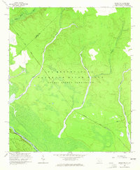
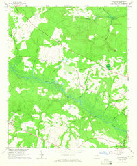
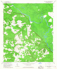
 1964 Idlewood1965 Print · USGSBurke County during the mid-1960s reveals a landscape of rural school-and-church centers and winding creek bottoms. Genealogists and local researchers can trace the locations of Watkinville Ch, the settlement of Alexander, and the path of the Central Georgia railroad.2 unique versions available
 - 1964 Map of Mc Bean, 1965 Print
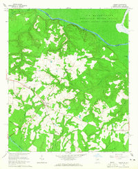
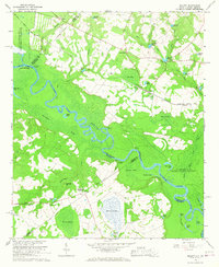
 1964 Mc Bean1965 Print · USGSBurke County during the mid-1960s was a landscape of creek-side settlements and active rail lines along the Central of Georgia corridor. Researchers can trace ancestral locations at Knight Cem, Cosnahan Cem, and rural parishes like Mt Zion Ch.2 unique versions available
 - 1964 Map of Alexander, 1965 Print
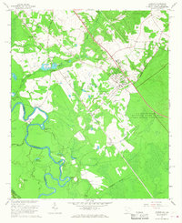
 1964 Alexander1965 Print · USGSBurke County in the mid-1960s was a landscape of river landings and remote family settlements. Genealogists can trace rural roots through Botsford Ch, Wimberly Cem, and the riverside community of Telfairville.2 unique versions available
 - 1964 Map of Millett, 1967 Print
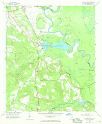
 1964 Millett1967 Print · USGSThe Savannah River valley in the early 1960s reveals a rural landscape adapting to the massive presence of the Savannah River Plant. Genealogists and historians can trace community hubs like Millett and Dunbar Store alongside landmarks like Zion Grove Ch.2 unique versions available
 - 1965 Map of Jackson, 1967 Print
 1965 Jackson1967 Print · USGSAiken County and the Georgia border are captured here during the mid-sixties, a period defined by the expansion of the Atomic Energy Commission reservation. Genealogists can trace family landmarks like Susan Union Cem, Wesley Chapel, and the community of Jackson.3 unique versions available
 - 1965 Map of Mechanic Hill, 1968 Print
 1965 Mechanic Hill1968 Print · USGSThe Savannah River bottomlands south of Augusta appear in the mid-sixties as a landscape of rural cemeteries and emerging industry. Genealogists and historians can trace family-named sites like Twiggs Cem and Broome Cem or the industrial footprint of Bush Field.4 unique versions available
 - 1965 Map of Shell Bluff Landing, 1968 Print
 1965 Shell Bluff Landing1968 Print · USGSThe Savannah River borderlands in the 1960s reveal the intersection of federal atomic energy sites and rural Georgia life. Researchers can trace family history through sites like Daniel Grove Ch, Allens Chapel, and the historic Shell Bluff Landing.3 unique versions available
End of results
Showing maps 1-15 of 15
Top cities of Burke County
- Waynesboro historical maps
- Sardis historical maps
- Midville historical maps
- Girard historical maps
- Vidette historical maps
Frequently asked questions
- What are the different types of historical maps available for Burke County?
- What is the oldest map of Burke County?
- Where can I purchase historical maps of Burke County for my home or office?
- Where can I download high-res historical maps of Burke County?
- Are there historical topographic maps available for Burke County?
- Is there historical aerial imagery available for Burke County?
- Where are historical maps of Burke County sourced from?