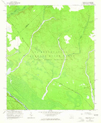
1964 Map of Girard NW
USGS Topo · Published 1965About this map
The U S Reservation Savannah River Plant (Atomic Energy Commission) dominates this landscape, reflecting a transformative era of Cold War industrial and nuclear development along the border of Aiken and Barnwell counties. While much of the terrain is marked by the specialized infrastructure of the facility, the natural hydrology remains a prominent feature. The Savannah River defines the southwestern boundary, fed by a complex network of tributaries including Upper Three Runs, Fourmile Branch, and Indian Grave Branch. Transportation through this restricted zone is anchored by the Atlantic Coast Line railroad and River Road, providing a glimpse into the logistical corridors necessary for both the industrial complex and the traditional river-valley commerce. Small watercourses like Steel Creek and Myers Br weave through the southern portion of the quadrangle, maintaining the geographic character of the Lowcountry wetlands despite the heavy federal footprint.
Find a feature on this map
16 named features on this map. Tap any name to fly to it.
Don’t see what you’re looking for? This feature index may not catch every label — zoom into the map to look around manually.
Map Details
Editions of this 1964 Girard NW Map
4 editions found
Other maps of this area

1920 · Ellenton
USGS Topo · 1:48,000

1920 · Greens Cut
USGS Topo · 1:62,500

1920 · Talatha
USGS Topo · 1:48,000

1921 · Augusta
USGS Topo · 1:62,500

1921 · Talatha
USGS Topo · 1:62,500

1921 · Ellenton
USGS Topo · 1:62,500

1943 · Greens Cut
USGS Topo · 1:62,500

1943 · Augusta East
USGS Topo · 1:125,000

1943 · Talatha
USGS Topo · 1:62,500

1943 · Augusta
USGS Topo · 1:62,500