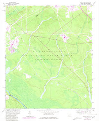
1964 Map of Girard NW
USGS Topo · Published 1981About this map
The Savannah River Plant dominates this South Carolina landscape, reflecting the mid-century industrial and military development of the region. Bordered by the Savannah River at the Georgia state line, the area is defined by a dense network of hydrologic features including Upper Three Runs and Fourmile Branch. The map reveals the specialized infrastructure required for this massive energy complex, including the U S Government Railroad and various Water Tanks and substations. This 1964 survey, with 1981 photorevisions, documents the transformation of former rural tracts into a highly managed industrial zone. The southern portion of the quadrangle shows the river's winding path where Barnwell and Burke counties meet, while the interior remains a restricted zone where natural drainages like Steel Creek and Indian Grave Branch flow through a landscape of controlled utility and government oversight.
Find a feature on this map
19 named features on this map. Tap any name to fly to it.
Don’t see what you’re looking for? This feature index may not catch every label — zoom into the map to look around manually.
Map Details
Editions of this 1964 Girard NW Map
4 editions found
Other maps of this area

1920 · Ellenton
USGS Topo · 1:48,000

1920 · Greens Cut
USGS Topo · 1:62,500

1920 · Talatha
USGS Topo · 1:48,000

1921 · Augusta
USGS Topo · 1:62,500

1921 · Talatha
USGS Topo · 1:62,500

1921 · Ellenton
USGS Topo · 1:62,500

1943 · Greens Cut
USGS Topo · 1:62,500

1943 · Augusta East
USGS Topo · 1:125,000

1943 · Talatha
USGS Topo · 1:62,500

1943 · Augusta
USGS Topo · 1:62,500