1960s Maps of Honolulu County, Hawaii
Explore 19 historic maps of Honolulu County from the 1960s. These maps offer a rare glimpse into what life looked like during the 1960s — showing old roads, neighborhoods, homes, and landmarks that have changed or disappeared over time.
Whether you're researching your family's past, planning a metal detecting trip, or studying how Honolulu County's landscape evolved across the 1960s, these high-resolution maps are a powerful tool for exploring the history of this region.
- Focus on a specific era: All maps on this page are from the 1960s, giving you a focused view of this time period.
- See what’s changed: Compare century-old streets, trails, and buildings to today's modern landscape using overlays and satellite layers.
- Research with precision: Use these maps for genealogy, historical research, land use analysis, or educational projects.
- View, download, or print: Maps are fully viewable online in high resolution, and can be downloaded or printed for your own records.
Start exploring Honolulu County's history through authentic maps from the 1960s. This is your window into the past.
Honolulu County, HI maps
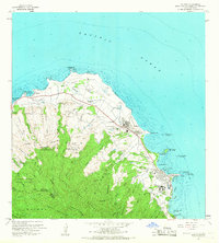
(19)- 1960 Map of Haleiwa, 1961 Print
 1960 Haleiwa1961 Print · USGSOahu's North Shore and the Wahiawa Plateau are documented here during the height of the mid-century plantation era. Genealogists and historians can trace laborers' quarters at Poamoho Camp, the industrial Sugar Mill in Waialua, and the layout of Schofield Barracks.2 unique versions available
 - 1960 Map of Schofield Barracks, 1962 Print
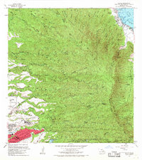
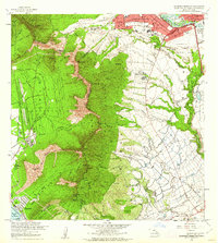 1960 Schofield Barracks1962 Print · USGSCentral Oahu and the Waianae Range are captured here during a period of significant military and agricultural activity. Researchers can trace the layout of Schofield Barracks, locate Kunia Camp, and find landmarks like Wheeler Field and Kolekole Pass.
 - 1961 Map of Oahu
 1961 Oahu1961 Print · USGSOahu's strategic landscape is captured here during the early statehood era, showing the balance between burgeoning urban centers and massive military installations. Trace the path of the Oahu Railway and Land Co or locate historical sites like Schofield Barracks and Punchbowl Hill.
 - 1962 Map of Ewa, 1963 Print
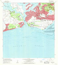
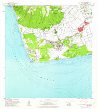 1962 Ewa1963 Print · USGSCoastal Oahu in the early sixties showcases a transition from plantation life to a modern military and industrial hub. Genealogists can trace family connections in Ewa and its surrounding worker communities like Tenney Village or Varona Village, while researchers can locate the massive Barbers Point Naval Air Station.2 unique versions available
 - 1963 Map of Waianae, 1965 Print
 1963 Waianae1965 Print · USGSThe Leeward Coast of Oahu comes alive in the early sixties as local homesteads and ancient sites meet expanding military reservations. Trace family roots and land divisions in Lualualei Homesteads or locate historical landmarks like Kaneaki Heiau and St Johns.2 unique versions available
 - 1964 Map of Kaena, 1966 Print
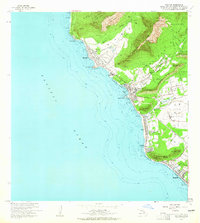
 1964 Kaena1966 Print · USGSThe western tip of Oahu is documented here in the mid-1960s, showing a blend of cattle ranching, military defense, and forest reserves. Researchers can locate the Old Railroad Grade, ranch holdings like Campbell Ranch, and landmarks like Kaneana Cave.
 - 1965 Map of Oahu
 1965 Oahu1965 Print · USGSOahu in the mid-sixties reveals a landscape defined by significant military installations and growing coastal communities. Researchers can trace the infrastructure of Pearl Harbor, Schofield Barracks, and landmarks like Diamond Head.2 unique versions available
 - 1965 Map of Kahuku, 1967 Print
 1965 Kahuku1967 Print · USGSThe northern tip of Oahu is captured in the mid-sixties, showing the intersection of coastal development and the dense Koolau Range. You can trace the footprint of the Polynesian Cultural Center, locate the Sacred Heart Seminary, and follow the Old Railroad Grade through Kahuku.2 unique versions available
 - 1966 Map of Waimea, 1967 Print
 1966 Waimea1967 Print · USGSThe North Shore of Oahu in the mid-1960s reveals a landscape of ancient sacred sites and burgeoning coastal settlements. Researchers can trace the heritage of Puu O Mahuka Heiau, the expanse of Kalou Marsh, and the grounds of Camp Pupukea.
 - 1966 Map of Hauula, 1968 Print
 1966 Hauula1968 Print · USGSOahu's windward coast and central plateau are captured in the mid-sixties, showing the growth of towns like Hauula and Whitmore Village. Local researchers can locate community landmarks such as Our Lady of Sorrows Sch and the Wahiawa Homesteads.
 - 1967 Map of Kahana, 1968 Print
 1967 Kahana1968 Print · USGSWindward Oahu's coastline and forest reserves are documented in detail during the 1960s, from the peaks of the Koolau Range to the reefs of the Pacific. Local history researchers can locate specific plantation-era sites like Waikane Camp and the Sugar Mill (Ruin) Chimney, or trace ancient features like Huilua Pond.
 - 1967 Map of Schofield Barracks, 1968 Print
 1967 Schofield Barracks1968 Print · USGSCentral Oahu in the late sixties shows a landscape shaped by military expansion and topographic extremes. Genealogists and historians can trace the footprints of Schofield Barracks, the homes at Kunia Camp, and the historic Kolekole Pass.
 - 1968 Map of Ewa, 1970 Print
 1968 Ewa1970 Print · USGSCoastal Oahu at the end of the sixties reveals a transition from sugar plantation life to military and industrial expansion. Genealogists and historians can trace the layouts of Varona Village, see the massive Barbers Point Naval Air Station, and find old infrastructure like the OR & L railroad.
 - 1968 Map of Mokapu, 1970 Print
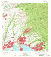
 1968 Mokapu1970 Print · USGSCoastal Oahu in the late sixties reveals a mix of expanding suburbs and significant military installations along the Windward shore. Local researchers can trace residential growth in Kailua, explore the Kawainui Swamp basin, or locate landmarks like Ulupau Crater and St Anthony Sch.2 unique versions available
 - 1968 Map of Puuloa, 1970 Print
 1968 Puuloa1970 Print · USGSThe southern coast of Oahu in the late sixties shows the deep integration of military and civilian life around the harbor. Trace the footprints of Hickam Air Force Base, find the memorial sites for the USS Arizona and USS Utah, or locate neighborhood landmarks like Campbell High Sch and Ewa Beach.2 unique versions available
 - 1968 Map of Kaneohe, 1970 Print
 1968 Kaneohe1970 Print · USGSWindward Oahu's coastline and valleys are captured here in the late sixties as traditional homesteads and modern developments meet. Trace family roots and land use through the Waiahole Homesteads, the Byodo-In Temple, and Puohala Village.2 unique versions available
 - 1968 Map of Waipahu, 1971 Print
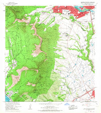
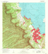
 1968 Waipahu1971 Print · USGSThe northern shores of Pearl Harbor were undergoing a massive suburban transformation in the late sixties as new communities like Mililani Town emerged. Genealogists and historians can trace the foundations of modern Oahu through the Sugar Mill, Kalaauo Spring, and numerous local schools like August Ahrens Sch.
 - 1969 Map of Honolulu, 1971 Print
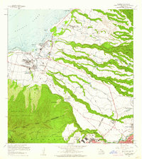
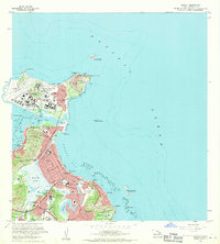
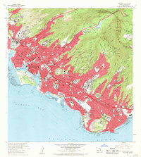 1969 Honolulu1971 Print · USGSIn the late 1960s, Honolulu’s modern skyline was rising against the backdrop of ancient volcanic craters and steep emerald ridges. Researchers can trace the mid-century city layout, identifying landmarks like Diamond Head, the Punchbowl, and the Aloha Tower.2 unique versions available
 - 1969 Map of Koko Head, 1971 Print
 1969 Koko Head1971 Print · USGSSoutheastern Oahu undergoes a period of rapid suburban transformation in the late sixties as new coastal developments take root. Researchers can trace the early footprint of Hawaii Kai, the grounds of the Kawailoa Girls Home, and landmarks like Makapuu Point.
End of results
Showing maps 1-19 of 19
Top cities of Honolulu County
- Honolulu historical maps
- Waipahu historical maps
- Mililani historical maps
- Pearl City historical maps
- Kailua historical maps
- Kapolei historical maps
See more
Frequently asked questions
- What are the different types of historical maps available for Honolulu County?
- What is the oldest map of Honolulu County?
- Where can I purchase historical maps of Honolulu County for my home or office?
- Where can I download high-res historical maps of Honolulu County?
- Are there historical topographic maps available for Honolulu County?
- Is there historical aerial imagery available for Honolulu County?
- Where are historical maps of Honolulu County sourced from?