1990s Maps of Honolulu County, Hawaii
Explore 15 historic maps of Honolulu County from the 1990s. These maps offer a rare glimpse into what life looked like during the 1990s — showing old roads, neighborhoods, homes, and landmarks that have changed or disappeared over time.
Whether you're researching your family's past, planning a metal detecting trip, or studying how Honolulu County's landscape evolved across the 1990s, these high-resolution maps are a powerful tool for exploring the history of this region.
- Focus on a specific era: All maps on this page are from the 1990s, giving you a focused view of this time period.
- See what’s changed: Compare century-old streets, trails, and buildings to today's modern landscape using overlays and satellite layers.
- Research with precision: Use these maps for genealogy, historical research, land use analysis, or educational projects.
- View, download, or print: Maps are fully viewable online in high resolution, and can be downloaded or printed for your own records.
Start exploring Honolulu County's history through authentic maps from the 1990s. This is your window into the past.
Honolulu County, HI maps
(15)- 1992 Map of Hauula, 2001 Print
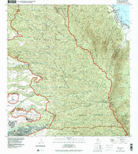 1992 Hauula2001 Print · USGSOahu's windward coast and central highlands are captured here in the early nineties, showing the island's blend of military infrastructure and natural preserves. Genealogists and historians can trace the developments of Hau'ula, Whitmore Village, and the expansive Schofield Barracks.
 - 1992 Map of Kahana, 2001 Print
 1992 Kahana2001 Print · USGSThe windward Oahu coastline in the 1990s reveals a landscape of coastal ponds and narrow settlements pressed against steep valley walls. Genealogists and hikers can trace property lines through the Grant Boundary or locate landmarks like the Ka'a'awa School and Huila Pond.
 - 1998 Map of Mokapu Point, 2000 Print
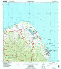
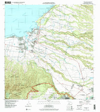
 1998 Mokapu Point2000 Print · USGSWindward Oahu at the close of the century shows a unique coastal landscape shaped by military presence and suburban growth. Trace local landmarks like the Marine Corps Base Hawaii, Kawainui Marsh, and the Ulukoi Heiau State Monument.
 - 1998 Map of Kaneohe, 2000 Print
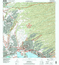
 1998 Kaneohe2000 Print · USGSWindward Oahu at the close of the century reveals a landscape where suburban Kaneohe meets historic coastal homesteads and mountain reserves. Trace local genealogy and land use through the Waiahole Homesteads, Byodo-In Temple, and Pu‘ohala Village.
 - 1998 Map of Waianae, 2000 Print
 1998 Waianae2000 Print · USGSThe Leeward Coast of Oahu comes alive in the late nineties, showing the vital connection between the shoreline and the deep interior valleys. Trace family history through the Wai'anae Homesteads, locate the Naval Transmitting Facility, or find local landmarks like Pōka'ī Bay.
 - 1998 Map of Kahuku, 2000 Print
 1998 Kahuku2000 Print · USGSOahu's North Shore and Windward Coast appear at the close of the century, showing a mix of institutional growth and shoreline preservation. Trace the development of La'ie near Brigham Young University or explore the Punamanō Nat Wildlife Refuge near Kahuku.
 - 1998 Map of Honolulu, 2000 Print
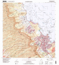
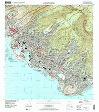 1998 Honolulu2000 Print · USGSHonolulu is captured in the late nineties, showcasing the city's unique geography where volcanic craters like Diamond Head meet a sprawling urban grid. Genealogists and historians can trace institutional landmarks and local neighborhoods from the Royal Mausoleum and Oahu Cemetery to Alewa Heights and Waialae.
 - 1998 Map of Schofield Barracks, 2000 Print
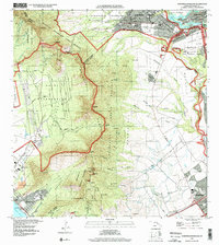 1998 Schofield Barracks2000 Print · USGSCentral Oahu at the close of the twentieth century shows a landscape shaped by military command and steep volcanic ridges. Researchers can trace the layout of Schofield Barracks, the Wahiawa Homesteads, and the path of the Waiahole Ditch.
 - 1998 Map of Waimea, 2000 Print
 1998 Waimea2000 Print · USGSThe North Shore of Oahu comes into focus in the late nineties, showing the established coastal communities and the preserved uplands. Trace the development of Pupukea Homesteads and find landmarks like Sunset Beach Sch and the Pu'uomahuka State Monument.
 - 1998 Map of Kaena, 2000 Print
 1998 Kaena2000 Print · USGSThe western tip of O'ahu's Waialua and Wai'anae districts comes into focus at the end of the century. You can trace the boundaries of the Makua Military Reservation and historic estates like Dillingham Ranch or Crowbar Ranch.
 - 1998 Map of Waipahu, 2000 Print
 1998 Waipahu2000 Print · USGSThe O'ahu central corridor is captured here at the end of the century, showing the dense development between the mountains and the sea. Researchers can trace the layout of Mililani Town, the Wheeler Air Force Base, and PEARL HARBOR.
 - 1998 Map of Ewa, 2000 Print
 1998 Ewa2000 Print · USGSThe Ewa Plain was in a state of rapid transformation at the end of the century as military lands transitioned to civilian use. Researchers can trace the layout of Naval Air Station Barbers Point and locate the historic plantation clusters of Tenney Village and Fernandez Village.
 - 1999 Map of Koko Head, 2000 Print
 1999 Koko Head2000 Print · USGSSoutheastern O'ahu shows its modern suburban and conservation character at the end of the millennium. Researchers can trace local development around Hawai'i Kai, the engineering of Kuapa Pond, and protected landmarks like Koko Crater.
 - 1999 Map of Haleiwa, 2000 Print
 1999 Haleiwa2000 Print · USGSThe North Shore of O‘ahu shows its plantation and military character at the end of the millennium. Researchers can locate legacy sites like the Sugar Mill and Kūkaniloko Birthstones State Monument or trace workers' housing at Kemo‘o Camp 4.
 - 1999 Map of Pearl Harbor, 2000 Print
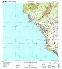
 1999 Pearl Harbor2000 Print · USGSThe southern coast of Oahu appears in remarkable detail at the end of the millennium, showing the dense military and civilian footprint around Pearl Harbor. Researchers can trace the layout of Hickam Air Force Base, find the USS Arizona Memorial, and locate local landmarks like Aloha Stadium.
End of results
Showing maps 1-15 of 15
Top cities of Honolulu County
- Honolulu historical maps
- Waipahu historical maps
- Mililani historical maps
- Pearl City historical maps
- Kailua historical maps
- Kapolei historical maps
See more
Frequently asked questions
- What are the different types of historical maps available for Honolulu County?
- What is the oldest map of Honolulu County?
- Where can I purchase historical maps of Honolulu County for my home or office?
- Where can I download high-res historical maps of Honolulu County?
- Are there historical topographic maps available for Honolulu County?
- Is there historical aerial imagery available for Honolulu County?
- Where are historical maps of Honolulu County sourced from?