1980s Maps of Honolulu County, Hawaii
Explore 15 historic maps of Honolulu County from the 1980s. These maps offer a rare glimpse into what life looked like during the 1980s — showing old roads, neighborhoods, homes, and landmarks that have changed or disappeared over time.
Whether you're researching your family's past, planning a metal detecting trip, or studying how Honolulu County's landscape evolved across the 1980s, these high-resolution maps are a powerful tool for exploring the history of this region.
- Focus on a specific era: All maps on this page are from the 1980s, giving you a focused view of this time period.
- See what’s changed: Compare century-old streets, trails, and buildings to today's modern landscape using overlays and satellite layers.
- Research with precision: Use these maps for genealogy, historical research, land use analysis, or educational projects.
- View, download, or print: Maps are fully viewable online in high resolution, and can be downloaded or printed for your own records.
Start exploring Honolulu County's history through authentic maps from the 1980s. This is your window into the past.
Honolulu County, HI maps
(15)- 1981 Map of Puuloa
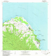
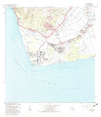
 1981 Puuloa1981 Print · USGSThe coastal interface of Honolulu comes into sharp focus in the late 1970s through this aerial orthophotoquad. Researchers can trace the massive scale of 20th-century coastal engineering around Ahua Pt and the rugged shoreline at Keahi Point.
 - 1983 Map of Koko Head
 1983 Koko Head1983 Print · USGSSoutheastern Oahu in the early eighties shows a landscape of rapid coastal change and suburban expansion. Researchers can trace the development of Hawaii Kai and locate historical institutions like the Kawailoa Girls Home and Bellows Air Force Station.
 - 1983 Map of Kahuku
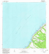
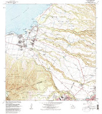
 1983 Kahuku1983 Print · USGSThe northern tip of Oahu comes into focus in the early 1980s, documenting a mix of university expansion and coastal conservation. Researchers can trace the grounds of Brigham Young University, the Laie Temple, and protected areas like Punamano Nat Wildlife Refuge.2 unique versions available
 - 1983 Map of Waimea
 1983 Waimea1983 Print · USGSThe North Shore of Oahu in the early eighties shows a landscape of world-famous beaches and deep cultural heritage. Trace the coastline from Sunset Beach down to Waimea Bay, locating ancient sites like Kupupolo Heiau and the grounds of Waimea Falls.2 unique versions available
 - 1983 Map of Mokapu
 1983 Mokapu1983 Print · USGSWindward Oahu in the early eighties shows a landscape defined by military installations and suburban growth along the coast. Researchers can find cultural landmarks like Ulupo Heiau, early residential areas such as Keolu Hills, and the Kailua Boys Home.
 - 1983 Map of Kaneohe
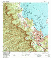 1983 Kaneohe1983 Print · USGSCoastal Oahu in the early 1980s reveals a transition from traditional homesteads to modern suburban centers along the windward shore. Researchers can trace the development of Kaneohe and Puoala Village alongside landmarks like the Byodo-In Temple and Hoomaluhia Park.2 unique versions available
 - 1983 Map of Hauula
 1983 Hauula1983 Print · USGSWindward Oahu meets the central highlands in the early eighties, showcasing a mix of coastal villages and military installations. Genealogists and historians can locate Hauula homes, Leilehua High Sch, and the deep interior of the Koolau Range.2 unique versions available
 - 1983 Map of Kahana
 1983 Kahana1983 Print · USGSThe windward coast of Oahu is captured here in the early eighties, showing the region's traditional fishponds and steep mountain topography. You can trace coastal settlements like Kaaawa and Punaluu, or locate landmarks such as Molii Pond and Mokolii Island (Chinamans Hat).2 unique versions available
 - 1983 Map of Waianae
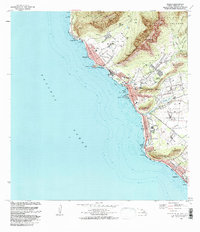 1983 Waianae1983 Print · USGSThe leeward Oahu coast in the early eighties shows a dense network of homesteads and ancient Hawaiian sites. You can trace cultural landmarks like Kaneaki Heiau and the Kuilioloa Heiau (Site) alongside the Waianae Homesteads.2 unique versions available
 - 1983 Map of Ewa
 1983 Ewa1983 Print · USGSThe Ewa Plain of Oahu in the early eighties shows a unique landscape where plantation villages and a major naval air station meet. Genealogists and historians can trace residential roots in Tenney Village and Renton Village or locate the historic Sugar Mill and Barbers Point Light.2 unique versions available
 - 1983 Map of Haleiwa
 1983 Haleiwa1983 Print · USGSOahu's North Shore is captured here in the early 1980s, documenting the vital irrigation networks and plantation camps of the coastal plains. Researchers can trace the layout of Haleiwa, locate the Sugar Mill in Waialua, or explore military history at Schofield Barracks Military Reservation.
 - 1983 Map of Schofield Barracks
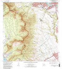 1983 Schofield Barracks1983 Print · USGSCentral Oahu in the early 1980s shows a landscape defined by massive military installations and the transition from agriculture to suburban growth. Researchers can trace the boundaries of Schofield Barracks and find local landmarks like the Wahiawa Reservoir or the Waiahole Ditch.
 - 1983 Map of Pearl Harbor, 1984 Print
 1983 Pearl Harbor1984 Print · USGSPearl Harbor and Honolulu's coast are shown here in the early eighties as a dense network of military installations and suburban growth. Researchers can locate the USS Arizona and USS Utah memorials, or trace the development of Ewa Beach and Aliamanu.2 unique versions available
 - 1983 Map of Waipahu, 1984 Print
 1983 Waipahu1984 Print · USGSOahu's central corridor underwent rapid transformation in the early eighties as new residential developments climbed the ridges above Pearl Harbor. Trace the growth of Mililani Town and Pearl City alongside landmarks like Aloha Stadium and Keaiwa Heiau State Park.
 - 1983 Map of Honolulu, 1986 Print
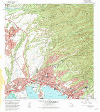
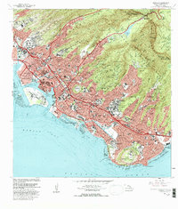 1983 Honolulu1986 Print · USGSHonolulu in the early eighties shows a dense urban sprawl climbing into the volcanic ridges of the Koolau Range. Genealogists and historians can trace the footprints of Kamehameha Schools, Punahou School, and landmark cemeteries like Oahu Cem.
End of results
Showing maps 1-15 of 15
Top cities of Honolulu County
- Honolulu historical maps
- Waipahu historical maps
- Mililani historical maps
- Pearl City historical maps
- Kailua historical maps
- Kapolei historical maps
See more
Frequently asked questions
- What are the different types of historical maps available for Honolulu County?
- What is the oldest map of Honolulu County?
- Where can I purchase historical maps of Honolulu County for my home or office?
- Where can I download high-res historical maps of Honolulu County?
- Are there historical topographic maps available for Honolulu County?
- Is there historical aerial imagery available for Honolulu County?
- Where are historical maps of Honolulu County sourced from?