1970s Maps of Honolulu County, Hawaii
Explore 13 historic maps of Honolulu County from the 1970s. These maps offer a rare glimpse into what life looked like during the 1970s — showing old roads, neighborhoods, homes, and landmarks that have changed or disappeared over time.
Whether you're researching your family's past, planning a metal detecting trip, or studying how Honolulu County's landscape evolved across the 1970s, these high-resolution maps are a powerful tool for exploring the history of this region.
- Focus on a specific era: All maps on this page are from the 1970s, giving you a focused view of this time period.
- See what’s changed: Compare century-old streets, trails, and buildings to today's modern landscape using overlays and satellite layers.
- Research with precision: Use these maps for genealogy, historical research, land use analysis, or educational projects.
- View, download, or print: Maps are fully viewable online in high resolution, and can be downloaded or printed for your own records.
Start exploring Honolulu County's history through authentic maps from the 1970s. This is your window into the past.
Honolulu County, HI maps
(13)- 1970 Map of Oahu, 1973 Print
 1970 Oahu1973 Print · USGSOahu was entering a new era of suburban and military expansion in the early seventies. Trace the growth of Mililani Town and Pearl City, or locate historic sites like Schofield Barracks and Diamond Head State Monument.2 unique versions available
 - 1977 Map of Ewa, 1981 Print
 1977 Ewa1981 Print · USGSThe southwestern coast of Oahu comes into sharp focus in the late seventies as industrial and military infrastructure expands across the Ewa plain. Researchers can trace the massive runway layouts near Barbers Point and identify coastal landmarks like Kahe Point.
 - 1977 Map of Haleiwa, 1984 Print
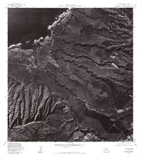 1977 Haleiwa1984 Print · USGSThe North Shore of Oahu comes into focus during the late seventies, showing the coastal community of Haleiwa and its surrounding agricultural fields. Researchers can trace land use patterns near Puaena Point and the military grounds of Schofield Barracks.
 - 1977 Map of Hauula, 1984 Print
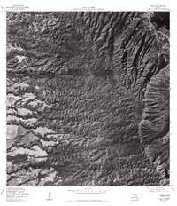 1977 Hauula1984 Print · USGSThe windward coast and central uplands of Oahu are captured here in the late seventies, showing the landscape before recent decades of growth. Genealogists and researchers can trace the limits of Hauula and Wahiawa, or locate the Ku Tree Res and Kaluanui Stream.
 - 1977 Map of Schofield Barracks, 1984 Print
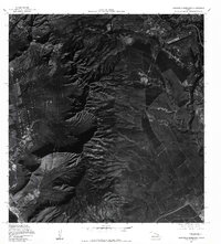 1977 Schofield Barracks1984 Print · USGSThe O'ahu interior comes into focus in the late seventies, showing the integration of military life and island topography. Researchers can trace the layout of Schofield Barracks and the coastal developments at Nanakuli and the ammunition depot at Niulii Res.
 - 1977 Map of Kahuku, 1984 Print
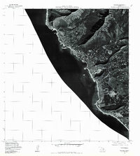
 1977 Kahuku1984 Print · USGSThe northern reaches of Oahu are shown in detail during the late seventies, following the shoreline from the point through local settlements. Researchers can trace the exact building footprints and field patterns in Kahuku and Laie near Makahoa Point.
 - 1977 Map of Kaena, 1984 Print
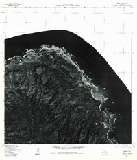
 1977 Kaena1984 Print · USGSThe western tip of Oahu is captured in the late seventies, showing the sharp divide between coastal development and the steep interior. Trace the shoreline from the airfield at Mokuleia around Kaena Point to the dramatic mouth of Makua Valley.
 - 1977 Map of Waianae, 1984 Print
 1977 Waianae1984 Print · USGSOahu's leeward coast comes into sharp focus during the late seventies, showing the residential and agricultural landscape of the era. Genealogists and local historians can trace property layouts and coastal development in Waianae, Makaha, and Nanakuli.
 - 1977 Map of Waimea, 1984 Print
 1977 Waimea1984 Print · USGSThe North Shore of Oahu is captured in detail during the late seventies, showing the transition of this famous coastline before modern development. Researchers can trace the layout of Waimea and the beachfront at Kawailoa Beach alongside the waters of Waimea Bay.
 - 1978 Map of Mokapu, 1981 Print
 1978 Mokapu1981 Print · USGSThe windward coast of Oahu comes into focus during the late seventies through this detailed aerial orthophotoquad. Local researchers can trace the development of coastal neighborhoods and the exact footprint of Kawainui Swamp during this era.
 - 1978 Map of Koko Head, 1981 Print
 1978 Koko Head1981 Print · USGSSoutheastern Oahu in the late seventies reveals a landscape of rapid suburban growth set against ancient volcanic landmarks. Researchers can trace development patterns around Maunalua Bay and study the terrain of Koko Head and Olomana Peak.
 - 1978 Map of Honolulu, 1981 Print
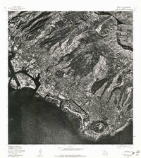 1978 Honolulu1981 Print · USGSThe city of Honolulu is captured in sharp aerial detail during the mid-seventies, showing the urban landscape from the harbor to the mountains. Researchers can trace development patterns around the iconic DIAMOND HEAD crater and the heights of KONAHUANUI.
 - 1978 Map of Kahana, 1984 Print
 1978 Kahana1984 Print · USGSThe windward coast of Oahu comes into sharp focus during the late 1970s, showing the early footprints of coastal development and land use. Genealogists and historians can trace the residential layout of Kahana and Kaaawa or study the shoreline at Kaoio Point.
End of results
Showing maps 1-13 of 13
Top cities of Honolulu County
- Honolulu historical maps
- Waipahu historical maps
- Mililani historical maps
- Pearl City historical maps
- Kailua historical maps
- Kapolei historical maps
See more
Frequently asked questions
- What are the different types of historical maps available for Honolulu County?
- What is the oldest map of Honolulu County?
- Where can I purchase historical maps of Honolulu County for my home or office?
- Where can I download high-res historical maps of Honolulu County?
- Are there historical topographic maps available for Honolulu County?
- Is there historical aerial imagery available for Honolulu County?
- Where are historical maps of Honolulu County sourced from?