1960s Maps of Adams County, Idaho
Explore 8 historic maps of Adams County from the 1960s. These maps offer a rare glimpse into what life looked like during the 1960s — showing old roads, neighborhoods, homes, and landmarks that have changed or disappeared over time.
Whether you're researching your family's past, planning a metal detecting trip, or studying how Adams County's landscape evolved across the 1960s, these high-resolution maps are a powerful tool for exploring the history of this region.
- Focus on a specific era: All maps on this page are from the 1960s, giving you a focused view of this time period.
- See what’s changed: Compare century-old streets, trails, and buildings to today's modern landscape using overlays and satellite layers.
- Research with precision: Use these maps for genealogy, historical research, land use analysis, or educational projects.
- View, download, or print: Maps are fully viewable online in high resolution, and can be downloaded or printed for your own records.
Start exploring Adams County's history through authentic maps from the 1960s. This is your window into the past.
Adams County, ID maps
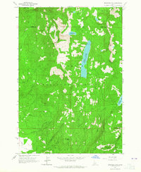
(8)- 1963 Map of Bally Mountain, 1964 Print
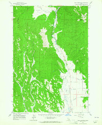 1963 Bally Mountain1964 Print · USGSThe Little Salmon River corridor comes alive in the early sixties as it flows between the high timber of the Payette National Forest and the ranch lands of Meadows Valley. Local researchers can trace family landmarks like the Circle C Ranch and early recreational sites such as Hot Springs.2 unique versions available
 - 1963 Map of Indian Mountain, 1965 Print
 1963 Indian Mountain1965 Print · USGSIn the Idaho backcountry during the early sixties, the Little Salmon River provided the only major passage through the Payette National Forest. Researchers can trace remote Jeep Trails and locate high-altitude landmarks like Indian Mountain and Tepee Springs.2 unique versions available
 - 1963 Map of Railroad Saddle, 1965 Print
 1963 Railroad Saddle1965 Print · USGSAdams County’s high timberlands are mapped here in the early sixties, showing the vital water and forest management sites of the Payette National Forest. Trace the early Jeep Trail through Railroad Saddle and locate the Price Valley Guard Station along the Weiser River.2 unique versions available
 - 1963 Map of Granite Lake, 1965 Print
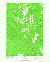
 1963 Granite Lake1965 Print · USGSThe high timber and water systems of the Payette National Forest are shown here as they appeared in the early 1960s. Researchers can trace historic landmarks like Sater Meadows, the Brundage Reservoir, and the remote Landing site.3 unique versions available
 - 1963 Map of Pollock Mountain, 1965 Print
 1963 Pollock Mountain1965 Print · USGSHigh-altitude wilderness and mining prospects define this pocket of the Payette National Forest in the early 1960s. Genealogists and researchers can trace isolated landmarks like Paradise Cabin, the Black Leopard Discovery Mine, and a lonely mountain Grave.3 unique versions available
 - 1963 Map of Brundage Mtn, 1965 Print
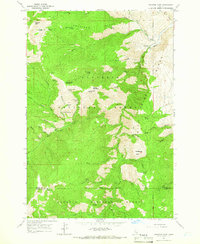
 1963 Brundage Mtn1965 Print · USGSThe high backcountry of the Payette National Forest is captured here in the early 1960s, showing the early development of mountain recreation. Trace the original trails and infrastructure around Brundage Mtn Ski Area, Goose Lake, and the remote Twin Lakes.
 - 1964 Map of Pollock, 1966 Print
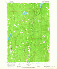
 1964 Pollock1966 Print · USGSThe Little Salmon River canyon serves as a vital corridor for high-mountain life in the mid-sixties, where county lines meet at the river's edge. Local historians can trace the early footprints of Pollock and Pinehurst alongside mountain landmarks like Sheep Mountain and Dempsey Flat.2 unique versions available
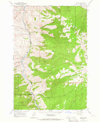
 - 1964 Map of Heavens Gate, 1966 Print
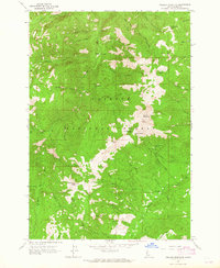
 1964 Heavens Gate1966 Print · USGSThe high divide between the Nez Perce and Payette National Forests comes into focus in the mid-1960s. Genealogists and historians can trace remote outposts and cabins like Silvers Station, Wurtz Cabin, and the Rapid River Fish Hatchery.4 unique versions available
End of results
Showing maps 1-8 of 8
Top cities of Adams County
Frequently asked questions
- What are the different types of historical maps available for Adams County?
- What is the oldest map of Adams County?
- Where can I purchase historical maps of Adams County for my home or office?
- Where can I download high-res historical maps of Adams County?
- Are there historical topographic maps available for Adams County?
- Is there historical aerial imagery available for Adams County?
- Where are historical maps of Adams County sourced from?