Old Maps of Bingham County, Idaho for Hiking & Exploration
Hike through history with 388 historic maps of Bingham County. Explore old trails, ghost towns, and forgotten backroads — perfect for outdoor adventurers and local explorers.
- Rediscover forgotten places: Map out old mining camps, roads, and footpaths that no longer exist on modern maps.
- Layer with modern tools: Combine with LiDAR or satellite views to plan hikes through historical terrain.
- Made for exploration: Popular among hikers, overlanders, and local history lovers.
Use these maps to find adventure and explore the hidden past of Bingham County.
Bingham County, ID maps
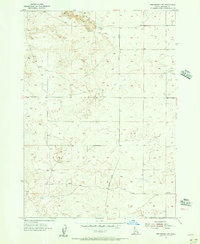
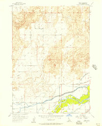
(388)- 1917 Map of Cranes Flat
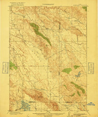 1917 Cranes Flat1917 Print · USGSSoutheast Idaho's high-plateau ranching country is shown here just before the First World War, where mountain ranges separate wide, arid basins. Researchers can locate the early Hancock Ranch and trace the original shoreline of the Blackfoot River Reservoir and Cranes Creek.3 unique versions available
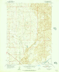
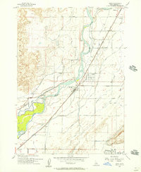
 - 1918 Map of Paradise Valley
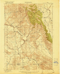 1918 Paradise Valley1918 Print · USGSSouthern Idaho during the First World War era reveals a landscape defined by the Fort Hall Indian Reservation and the high Blackfoot Mountains. Genealogists and local historians can locate early landmarks like Morgan, Aldridge, and the Austin Ranch nestled along the Blackfoot River.3 unique versions available
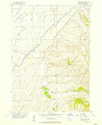
 - 1924 Map of Hell Creek, 1958 Print
 1924 Hell Creek1958 Print · USGSSoutheast Idaho's high country is captured here during the mid-twenties, showcasing the rural life of Bonneville and Bingham Counties. Genealogists and local historians can trace family-named landmarks like Skelly Hill, the remote Dehlin School, and the early Hell Creek Ranger Station.2 unique versions available
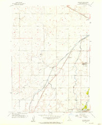
 - 1924 Map of Ammon, 1958 Print
 1924 Ammon1958 Print · USGSSoutheast Idaho at the dawn of the motorized age shows a landscape of developing irrigation and rural schools. You can trace the path of the Union Pacific through Ammon or locate historic schoolhouses like Dewey School and Henry Creek School.3 unique versions available
 - 1926 Map of Hell Creek
 1926 Hell Creek1926 Print · USGSThe ranching and forest lands of eastern Idaho are captured here in the mid-1920s. Researchers can trace the rural infrastructure of the day, from the Dehlin School to the remote Fall Creek Ranger Sta and the waters of Tex Creek.2 unique versions available
 - 1934 Map of American Falls, 1957 Print
 1934 American Falls1957 Print · USGSThe Snake River region in the mid-1930s shows a landscape of massive water projects and ranching roots. Genealogists and historians can trace the Old Oregon Trail, locate remote rural schools like Mt Hope Sch, and see the early footprint of the American Falls Dam.
 - 1934 Map of Michaud, 1957 Print
 1934 Michaud1957 Print · USGSThe Fort Hall Indian Reservation was undergoing significant changes in the 1930s as the American Falls Reservoir reshaped the valley. Genealogists and historians can trace the paths of the Oregon Trail, locate the Indian Cem, and find old rail stops at Schiller and Michaud.
 - 1936 Map of American Falls
 1936 American Falls1936 Print · USGSPower and Bingham counties are captured in the mid-1930s, showing the early years of the massive reservoir on the Snake River. Genealogists and historians can trace family-named sites like Kerr Ranch and a network of schools including Williams Sch and Range Sch.
 - 1937 Map of Michaud
 1937 Michaud1937 Print · USGSThe Fort Hall Indian Reservation and its mid-century transportation networks are documented here just as the aviation age was taking flight. Genealogists and historians can trace family-named sites and early infrastructure like the Indian School, Indian Cem, and the path of the Old Oregon Trail.
 - 1940 Map of Blackfoot, 1958 Print
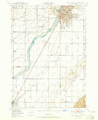
 1940 Blackfoot1958 Print · USGSBingham County at the dawn of the 1940s reveals a landscape defined by the Snake River and a vast irrigation network. Genealogists and historians can trace the Fort Hall Indian Reservation boundaries, find School No 12, and locate the Indian Agency and Ross Fork Indian Sch.
 - 1943 Map of Blackfoot
 1943 Blackfoot1943 Print · USGSSoutheastern Idaho's river valleys and irrigation networks are on full display in the early 1940s, centered on the confluence of the Snake River and Blackfoot River. Genealogists and historians can trace family-named waterworks like Wearyrick Ditch and explore the historic layout of the Fort Hall Indian Reservation and Blackfoot.2 unique versions available
 - 1948 Map of Woodville, 1954 Print
 1948 Woodville1954 Print · USGSThe eastern Snake River Plain in the late 1940s reveals a landscape split between volcanic fields and irrigation. Genealogists and historians can trace family-named waterworks like the Olson Canal and Hanson Canal near the settlement of Woodville.
 - 1948 Map of Idaho Falls South, 1965 Print
 1948 Idaho Falls South1965 Print · USGSIn the late 1940s, the area south of Idaho Falls was a thriving agricultural valley defined by a sophisticated irrigation network and the SNAKE RIVER. Genealogists and local historians can trace rural school districts like Stanton Sch and York Sch, alongside landmarks such as the LDS Temple and Fielding Memorial Cem.3 unique versions available
 - 1950 Map of Woodville
 1950 Woodville1950 Print · USGSSoutheast Idaho at mid-century reveals a landscape divided between the ancient Lava flows and a burgeoning agricultural network. Researchers can trace the development of irrigation systems like the Great Western Canal and locate the Woodville Cem near the banks of the Snake River.
 - 1950 Map of Idaho Falls South
 1950 Idaho Falls South1950 Print · USGSThe Snake River Plain south of Idaho Falls reveals an intricate mid-century network of irrigation canals and rural school districts. Genealogists can locate family landmarks like New Sweden Cemetery, the LDS Temple, and the Riverdale Sch (Aband'd).
 - 1950 Map of Goshen, 1976 Print
 1950 Goshen1976 Print · USGSIn the early 1950s, the Bingham County countryside was a complex network of rail and irrigation. Genealogists and local historians can trace family roots through the Goshen community, rural landmarks like the Jameston Sch, and the Union Pacific corridor.
 - 1951 Map of Higham Peak, 1952 Print
 1951 Higham Peak1952 Print · USGSThe Fort Hall Indian Reservation in the early fifties reveals a landscape of high peaks and vital waterways. Genealogists and historians can trace the Portneuf Presto Trail and locate family landmarks near Higham Peak or the Blackfoot River.2 unique versions available
 - 1952 Map of Goshen
 1952 Goshen1952 Print · USGSBingham County agriculture and irrigation are captured here in the early 1950s as water management reshaped the Snake River Plain. Trace the vital network of the Highline Canal and Idaho Canal alongside landmarks like Jameston Sch and the Snake River.
 - 1954 Map of Pocatello, 1963 Print
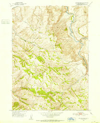
 1954 Pocatello1963 Print · USGSSoutheast Idaho in the mid-1950s reveals a landscape shaped by massive water reclamation and mountain forests. Researchers can trace the development of the Fort Hall Indian Reservation or locate specific landmarks like the Arbon P O and Emerson School.4 unique versions available
 - 1955 Map of Springfield NW, 1956 Print
 1955 Springfield NW1956 Print · USGSBingham County in the mid-1950s is shown as a rugged expanse of volcanic terrain and sparse ranching infrastructure. Researchers can trace early water management and transport routes through features like Number 1 Well, the Springfield Taber Road, and a Windmill.2 unique versions available
 - 1955 Map of Baldy Knoll, 1956 Print
 1955 Baldy Knoll1956 Print · USGSBingham County agriculture meets volcanic basalt flows in the mid-1950s. Genealogists and historians can trace irrigation development and local landmarks like Moreland, the Aberdeen Canal, and Lemhi Pass.2 unique versions available
 - 1955 Map of Lincoln Creek, 1957 Print
 1955 Lincoln Creek1957 Print · USGSThe Fort Hall Indian Reservation in the mid-1950s shows a landscape transformed by irrigation ditches and historic frontier sites. Researchers can locate the Fort Hall No. 2 Historic Site and trace water routes like the Presto Ditch and Lincoln Creek.2 unique versions available
 - 1955 Map of Rockford, 1957 Print
 1955 Rockford1957 Print · USGSBingham County agriculture and rail infrastructure are in focus during the mid-fifties, centered on the community of Rockford. Genealogists and historians can trace the irrigation network from Rockford Canal to Thomas and find local landmarks like the Snake River Jr High Sch.2 unique versions available
 - 1955 Map of Rose, 1957 Print
 1955 Rose1957 Print · USGSBingham County agriculture and irrigation are in full focus during the mid-fifties as the Snake River feeds an intricate canal network. Genealogists and local historians can trace the foundations of Rose and locate local landmarks like the Lavaside Sch and the Weggland school.2 unique versions available
 - 1955 Map of Firth, 1957 Print
 1955 Firth1957 Print · USGSBingham County agricultural life in the mid-fifties centered on the rail-and-river corridor between Shelley and Firth. Local historians can trace the intricate network of the Great Western Canal, the Hillcrest Cemetery, and the Basalt rail siding.2 unique versions available
Showing maps 1-25 of 388
Top cities of Bingham County
- Blackfoot historical maps
- Aberdeen historical maps
- Firth historical maps
- Basalt historical maps
- Atomic City historical maps
Frequently asked questions
- What are the different types of historical maps available for Bingham County?
- What is the oldest map of Bingham County?
- Where can I purchase historical maps of Bingham County for my home or office?
- Where can I download high-res historical maps of Bingham County?
- Are there historical topographic maps available for Bingham County?
- Is there historical aerial imagery available for Bingham County?
- Where are historical maps of Bingham County sourced from?