1930s Maps of Power County, Idaho
Explore 8 historic maps of Power County from the 1930s. These maps offer a rare glimpse into what life looked like during the 1930s — showing old roads, neighborhoods, homes, and landmarks that have changed or disappeared over time.
Whether you're researching your family's past, planning a metal detecting trip, or studying how Power County's landscape evolved across the 1930s, these high-resolution maps are a powerful tool for exploring the history of this region.
- Focus on a specific era: All maps on this page are from the 1930s, giving you a focused view of this time period.
- See what’s changed: Compare century-old streets, trails, and buildings to today's modern landscape using overlays and satellite layers.
- Research with precision: Use these maps for genealogy, historical research, land use analysis, or educational projects.
- View, download, or print: Maps are fully viewable online in high resolution, and can be downloaded or printed for your own records.
Start exploring Power County's history through authentic maps from the 1930s. This is your window into the past.
Power County, ID maps
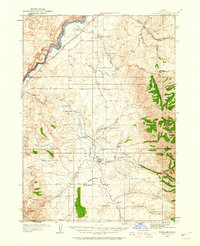
(8)- 1934 Map of American Falls, 1957 Print
 1934 American Falls1957 Print · USGSThe Snake River region in the mid-1930s shows a landscape of massive water projects and ranching roots. Genealogists and historians can trace the Old Oregon Trail, locate remote rural schools like Mt Hope Sch, and see the early footprint of the American Falls Dam.
 - 1934 Map of Michaud, 1957 Print
 1934 Michaud1957 Print · USGSThe Fort Hall Indian Reservation was undergoing significant changes in the 1930s as the American Falls Reservoir reshaped the valley. Genealogists and historians can trace the paths of the Oregon Trail, locate the Indian Cem, and find old rail stops at Schiller and Michaud.
 - 1934 Map of Rockland, 1960 Print
 1934 Rockland1960 Print · USGSPower County ranching and transit corridors are frozen in time during the mid-1930s, showing the early infrastructure of the Upper Snake River Valley. Researchers can trace the dual routes of the Oregon Trail and locate isolated schoolhouses like Garris Sch and Central Sch.2 unique versions available
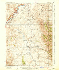
 - 1936 Map of American Falls
 1936 American Falls1936 Print · USGSPower and Bingham counties are captured in the mid-1930s, showing the early years of the massive reservoir on the Snake River. Genealogists and historians can trace family-named sites like Kerr Ranch and a network of schools including Williams Sch and Range Sch.
 - 1937 Map of Rockland
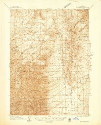
 1937 Rockland1937 Print · USGSRockland and the surrounding high-desert canyons are captured here in the mid-1930s as modern highways began to parallel historic western routes. Genealogists and historians can trace the Old Oregon Trail, locate the Cem at Rockland, and find rural schoolhouses like Cold Creek Sch and Garris Sch.2 unique versions available
 - 1937 Map of Pocatello
 1937 Pocatello1937 Print · USGSBannock County is captured in the late 1930s as a burgeoning rail and highway crossroads along the Portneuf River. Genealogists can locate family landmarks in old Alameda, trace the Fort Hall Mine, or find rural school sites like Blackrock Sch.3 unique versions available
 - 1937 Map of Michaud
 1937 Michaud1937 Print · USGSThe Fort Hall Indian Reservation and its mid-century transportation networks are documented here just as the aviation age was taking flight. Genealogists and historians can trace family-named sites and early infrastructure like the Indian School, Indian Cem, and the path of the Old Oregon Trail.
 - 1938 Map of Pauline
 1938 Pauline1938 Print · USGSBannock Valley in the late 1930s is a landscape of high-altitude ranching and early aviation landmarks. Genealogists and local historians can trace the foundations of Pauline and Arbon PO, or locate family sites like Rudeen Ranch and Armstrong Sch.
End of results
Showing maps 1-8 of 8
Top cities of Power County
Frequently asked questions
- What are the different types of historical maps available for Power County?
- What is the oldest map of Power County?
- Where can I purchase historical maps of Power County for my home or office?
- Where can I download high-res historical maps of Power County?
- Are there historical topographic maps available for Power County?
- Is there historical aerial imagery available for Power County?
- Where are historical maps of Power County sourced from?